
Size of this preview:
800 × 460 pixels. Other resolutions:
320 × 184 pixels |
640 × 368 pixels |
1,024 × 588 pixels |
1,280 × 735 pixels |
2,560 × 1,471 pixels |
3,573 × 2,053 pixels.
Original file (3,573 × 2,053 pixels, file size: 2.02 MB, MIME type: image/jpeg)
| This is a file from the
Wikimedia Commons. Information from its
description page there is shown below. Commons is a freely licensed media file repository. You can help. |
Summary
| Description |
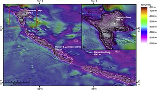
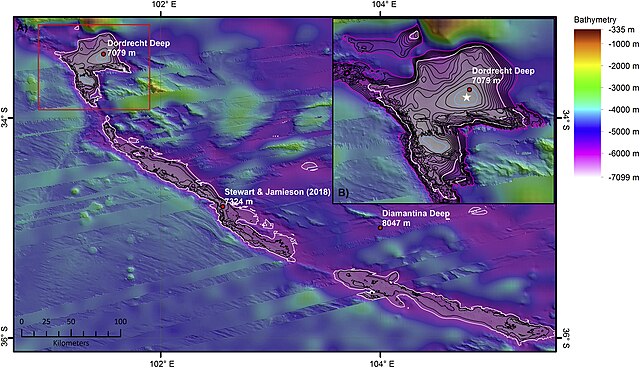
English: Map of the deepest section of the Diamantina Fracture Zone with the locations of published ‘deeps’ (red circles) (Table 1). The 6000 m depth contour is shown in white. The deepest section of the feature is defined by the 7000 m contour (blue). All other contours at 200 m intervals (between 6000 and 7000 m water depth) (B) Inset map of Dordrecht Deep with the deepest point determined during this study (white star = between 7090 and 7100 m water depth) which is within 4 km of the published GEBCO Gazetteer location for Dordrecht Deep. The outer rim of Dordrecht deep lies at 5300 m water depth (pink contour). The 7000 m contour is coloured blue. All other contours at 100 m intervals (between 5300 and 7000 m water depth). For location of inset map see the red box in Fig. 5A. Illumination from 45° at an altitude of 25°. |
| Date | |
| Source | Heather A. Stewart, Alan J. Jamieson: The five deeps: The location and depth of the deepest place in each of the world's oceans. In: Earth-Science Reviews 197, Oktober 2019, 102896, doi:10.1016/j.earscirev.2019.102896. |
| Author | Heather A. Stewart, Alan J. Jamieson |
| Permission ( Reusing this file) |
This is an open access article under the CC BY license ( https://creativecommons.org/licenses/BY/4.0/). |

Licensing
This file is licensed under the
Creative Commons
Attribution 4.0 International license.
- You are free:
- to share – to copy, distribute and transmit the work
- to remix – to adapt the work
- Under the following conditions:
- attribution – You must give appropriate credit, provide a link to the license, and indicate if changes were made. You may do so in any reasonable manner, but not in any way that suggests the licensor endorses you or your use.
File history
Click on a date/time to view the file as it appeared at that time.
| Date/Time | Thumbnail | Dimensions | User | Comment | |
|---|---|---|---|---|---|
| current | 21:25, 12 May 2020 |
| 3,573 × 2,053 (2.02 MB) | Jean-Hyacinthe | {{Information |description ={{en|1=Map of the deepest section of the Diamantina Fracture Zone with the locations of published ‘deeps’ (red circles) (Table 1). The 6000 m depth contour is shown in white. The deepest section of the feature is defined by the 7000 m contour (blue). All other contours at 200 m intervals (between 6000 and 7000 m water depth) (B) Inset map of Dordrecht Deep with the deepest point determined during this study (white star = between 7090 and 7100 m water depth) which... |
File usage
The following pages on the English Wikipedia use this file (pages on other projects are not listed):
Global file usage
The following other wikis use this file:
- Usage on de.wikipedia.org
- Usage on it.wikipedia.org
- Usage on www.wikidata.org
Metadata
Size of this preview:
800 × 460 pixels. Other resolutions:
320 × 184 pixels |
640 × 368 pixels |
1,024 × 588 pixels |
1,280 × 735 pixels |
2,560 × 1,471 pixels |
3,573 × 2,053 pixels.
Original file (3,573 × 2,053 pixels, file size: 2.02 MB, MIME type: image/jpeg)
| This is a file from the
Wikimedia Commons. Information from its
description page there is shown below. Commons is a freely licensed media file repository. You can help. |
Summary
| Description |
English: Map of the deepest section of the Diamantina Fracture Zone with the locations of published ‘deeps’ (red circles) (Table 1). The 6000 m depth contour is shown in white. The deepest section of the feature is defined by the 7000 m contour (blue). All other contours at 200 m intervals (between 6000 and 7000 m water depth) (B) Inset map of Dordrecht Deep with the deepest point determined during this study (white star = between 7090 and 7100 m water depth) which is within 4 km of the published GEBCO Gazetteer location for Dordrecht Deep. The outer rim of Dordrecht deep lies at 5300 m water depth (pink contour). The 7000 m contour is coloured blue. All other contours at 100 m intervals (between 5300 and 7000 m water depth). For location of inset map see the red box in Fig. 5A. Illumination from 45° at an altitude of 25°. |
| Date | |
| Source | Heather A. Stewart, Alan J. Jamieson: The five deeps: The location and depth of the deepest place in each of the world's oceans. In: Earth-Science Reviews 197, Oktober 2019, 102896, doi:10.1016/j.earscirev.2019.102896. |
| Author | Heather A. Stewart, Alan J. Jamieson |
| Permission ( Reusing this file) |
This is an open access article under the CC BY license ( https://creativecommons.org/licenses/BY/4.0/). |
Licensing
This file is licensed under the
Creative Commons
Attribution 4.0 International license.
- You are free:
- to share – to copy, distribute and transmit the work
- to remix – to adapt the work
- Under the following conditions:
- attribution – You must give appropriate credit, provide a link to the license, and indicate if changes were made. You may do so in any reasonable manner, but not in any way that suggests the licensor endorses you or your use.
File history
Click on a date/time to view the file as it appeared at that time.
| Date/Time | Thumbnail | Dimensions | User | Comment | |
|---|---|---|---|---|---|
| current | 21:25, 12 May 2020 |
| 3,573 × 2,053 (2.02 MB) | Jean-Hyacinthe | {{Information |description ={{en|1=Map of the deepest section of the Diamantina Fracture Zone with the locations of published ‘deeps’ (red circles) (Table 1). The 6000 m depth contour is shown in white. The deepest section of the feature is defined by the 7000 m contour (blue). All other contours at 200 m intervals (between 6000 and 7000 m water depth) (B) Inset map of Dordrecht Deep with the deepest point determined during this study (white star = between 7090 and 7100 m water depth) which... |
File usage
The following pages on the English Wikipedia use this file (pages on other projects are not listed):
Global file usage
The following other wikis use this file:
- Usage on de.wikipedia.org
- Usage on it.wikipedia.org
- Usage on www.wikidata.org