
Original file (1,105 × 1,027 pixels, file size: 153 KB, MIME type: image/jpeg)
| This is a file from the
Wikimedia Commons. Information from its
description page there is shown below. Commons is a freely licensed media file repository. You can help. |
Summary
| Description |
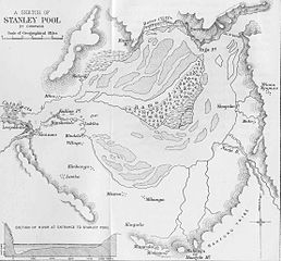
English: Map of the
Pool Malebo (Stanley Pool) — lake-like section of the lower
Congo River. Downriver on left edge
Kinshasa (south/lower bank) and
Brazzaville (north/upper bank), at transition from 'pool' to
Livingstone Falls rapids.
Français : Carte du
Stanley Pool (Pool Malebo).
Kinshasa et
Brazzaville. Image du XIXe siècle, Mont Mabangu ou Manguele, actuellement Mont Mangengenge, au sud. |
| Date | 19th century |
| Source | http://sourcebook.fsc.edu/history/congo01.jpg |
| Author | Unknown author |
Licensing
|
This work is in the public domain in its country of origin and other countries and areas where the copyright term is the author's life plus 70 years or fewer.
| |
| This file has been identified as being free of known restrictions under copyright law, including all related and neighboring rights. | |
File history
Click on a date/time to view the file as it appeared at that time.
| Date/Time | Thumbnail | Dimensions | User | Comment | |
|---|---|---|---|---|---|
| current | 20:41, 13 August 2006 |
| 1,105 × 1,027 (153 KB) | Moyogo | Carte du en:Stanley Pool, Kinshasa et Brazzaville,image du XIXe siècle. Mont Mabangu ou Manguele, actuellement Mont Mangengenge, au sud. Origine : http://sourcebook.fsc.edu/history/congo01.jpg |
File usage
Global file usage
The following other wikis use this file:
- Usage on af.wikipedia.org
- Usage on als.wikipedia.org
- Usage on ast.wikipedia.org
- Usage on de.wikipedia.org
- Usage on es.wikipedia.org
- Usage on fr.wikipedia.org
- Usage on gl.wikipedia.org
- Usage on ln.wikipedia.org
Metadata
Original file (1,105 × 1,027 pixels, file size: 153 KB, MIME type: image/jpeg)
| This is a file from the
Wikimedia Commons. Information from its
description page there is shown below. Commons is a freely licensed media file repository. You can help. |
Summary
| Description |
English: Map of the
Pool Malebo (Stanley Pool) — lake-like section of the lower
Congo River. Downriver on left edge
Kinshasa (south/lower bank) and
Brazzaville (north/upper bank), at transition from 'pool' to
Livingstone Falls rapids.
Français : Carte du
Stanley Pool (Pool Malebo).
Kinshasa et
Brazzaville. Image du XIXe siècle, Mont Mabangu ou Manguele, actuellement Mont Mangengenge, au sud. |
| Date | 19th century |
| Source | http://sourcebook.fsc.edu/history/congo01.jpg |
| Author | Unknown author |
Licensing
|
This work is in the public domain in its country of origin and other countries and areas where the copyright term is the author's life plus 70 years or fewer.
| |
| This file has been identified as being free of known restrictions under copyright law, including all related and neighboring rights. | |
File history
Click on a date/time to view the file as it appeared at that time.
| Date/Time | Thumbnail | Dimensions | User | Comment | |
|---|---|---|---|---|---|
| current | 20:41, 13 August 2006 |
| 1,105 × 1,027 (153 KB) | Moyogo | Carte du en:Stanley Pool, Kinshasa et Brazzaville,image du XIXe siècle. Mont Mabangu ou Manguele, actuellement Mont Mangengenge, au sud. Origine : http://sourcebook.fsc.edu/history/congo01.jpg |
File usage
Global file usage
The following other wikis use this file:
- Usage on af.wikipedia.org
- Usage on als.wikipedia.org
- Usage on ast.wikipedia.org
- Usage on de.wikipedia.org
- Usage on es.wikipedia.org
- Usage on fr.wikipedia.org
- Usage on gl.wikipedia.org
- Usage on ln.wikipedia.org