
Original file (831 × 1,809 pixels, file size: 525 KB, MIME type: image/jpeg)
| This is a file from the
Wikimedia Commons. Information from its
description page there is shown below. Commons is a freely licensed media file repository. You can help. |
Summary
| Description |
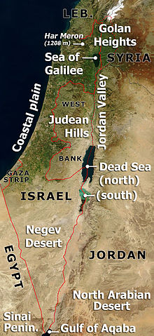
Annotated satellite image of Israel, the Palestinian territories and western Jordan, highlighting principal geographical features. Based on Image:Satellite image of Israel in January 2003.jpg If anyone wants to adapt this for a different language, please contact me ( ChrisO) - I can send the original .PSD file. |
| Date | 27 March 2007 (original upload date) |
| Source | No machine-readable source provided. Own work assumed (based on copyright claims). |
| Author | No machine-readable author provided. ChrisO assumed (based on copyright claims). |
Licensing
| This file is in the public domain in the United States because it was solely created by NASA. NASA copyright policy states that "NASA material is not protected by copyright unless noted". (See Template:PD-USGov, NASA copyright policy page or JPL Image Use Policy.) | ||
 |
Warnings:
|
| I, the copyright holder of this work, release this work into the
public domain. This applies worldwide. In some countries this may not be legally possible; if so: I grant anyone the right to use this work for any purpose, without any conditions, unless such conditions are required by law. |
File history
Click on a date/time to view the file as it appeared at that time.
| Date/Time | Thumbnail | Dimensions | User | Comment | |
|---|---|---|---|---|---|
| current | 21:24, 27 March 2007 |
| 831 × 1,809 (525 KB) | ChrisO | Annotated satellite image of Israel, the Palestinian territories and western Jordan, highlighting principal geographical features. Based on Image:Satellite image of Israel in January 2003.jpg ''If anyone wants to adapt this for a different language |
File usage
Global file usage
The following other wikis use this file:
- Usage on ca.wikipedia.org
- Usage on da.wikipedia.org
- Usage on es.wikipedia.org
- Usage on fr.wikipedia.org
- Usage on ha.wikipedia.org
- Usage on incubator.wikimedia.org
- Usage on it.wikipedia.org
- Usage on jv.wikipedia.org
- Usage on ko.wikipedia.org
- Usage on pt.wikipedia.org
- Usage on su.wikipedia.org
- Usage on uk.wikipedia.org
- Usage on www.wikidata.org
Metadata
Original file (831 × 1,809 pixels, file size: 525 KB, MIME type: image/jpeg)
| This is a file from the
Wikimedia Commons. Information from its
description page there is shown below. Commons is a freely licensed media file repository. You can help. |
Summary
| Description |
Annotated satellite image of Israel, the Palestinian territories and western Jordan, highlighting principal geographical features. Based on Image:Satellite image of Israel in January 2003.jpg If anyone wants to adapt this for a different language, please contact me ( ChrisO) - I can send the original .PSD file. |
| Date | 27 March 2007 (original upload date) |
| Source | No machine-readable source provided. Own work assumed (based on copyright claims). |
| Author | No machine-readable author provided. ChrisO assumed (based on copyright claims). |
Licensing
| This file is in the public domain in the United States because it was solely created by NASA. NASA copyright policy states that "NASA material is not protected by copyright unless noted". (See Template:PD-USGov, NASA copyright policy page or JPL Image Use Policy.) | ||
|
Warnings:
|
| I, the copyright holder of this work, release this work into the
public domain. This applies worldwide. In some countries this may not be legally possible; if so: I grant anyone the right to use this work for any purpose, without any conditions, unless such conditions are required by law. |
File history
Click on a date/time to view the file as it appeared at that time.
| Date/Time | Thumbnail | Dimensions | User | Comment | |
|---|---|---|---|---|---|
| current | 21:24, 27 March 2007 |
| 831 × 1,809 (525 KB) | ChrisO | Annotated satellite image of Israel, the Palestinian territories and western Jordan, highlighting principal geographical features. Based on Image:Satellite image of Israel in January 2003.jpg ''If anyone wants to adapt this for a different language |
File usage
Global file usage
The following other wikis use this file:
- Usage on ca.wikipedia.org
- Usage on da.wikipedia.org
- Usage on es.wikipedia.org
- Usage on fr.wikipedia.org
- Usage on ha.wikipedia.org
- Usage on incubator.wikimedia.org
- Usage on it.wikipedia.org
- Usage on jv.wikipedia.org
- Usage on ko.wikipedia.org
- Usage on pt.wikipedia.org
- Usage on su.wikipedia.org
- Usage on uk.wikipedia.org
- Usage on www.wikidata.org