Photos • Location


Size of this preview:
800 × 600 pixels. Other resolutions:
320 × 240 pixels |
640 × 480 pixels |
1,024 × 768 pixels |
1,280 × 960 pixels |
2,560 × 1,920 pixels |
2,816 × 2,112 pixels.
Original file (2,816 × 2,112 pixels, file size: 2.85 MB, MIME type: image/jpeg)
| This is a file from the
Wikimedia Commons. Information from its
description page there is shown below. Commons is a freely licensed media file repository. You can help. |
|
This is an image of a place or building that is listed on the
National Register of Historic Places in the
United States of America. Its reference number is
75001530. |
| Camera location |
| View this and other nearby images on: OpenStreetMap |
|
|---|
| Description |
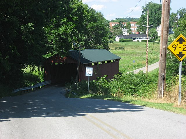
English: Western end of the
South Salem Covered Bridge, which carries Lower Twin Road across Buckskin Creek just west of
South Salem in
Buckskin Township,
Ross County,
Ohio,
United States. Built in 1873, this Smith truss bridge is listed on the
National Register of Historic Places. |
||
| Date | Taken on 10 July 2010 | ||
| Source | Own work | ||
| Author | Nyttend | ||
| Permission ( Reusing this file) |
|
File history
Click on a date/time to view the file as it appeared at that time.
| Date/Time | Thumbnail | Dimensions | User | Comment | |
|---|---|---|---|---|---|
| current | 22:20, 12 July 2010 |
| 2,816 × 2,112 (2.85 MB) | Nyttend | {{Location|39|20|3|N|83|18|52|W}} {{Information |Description={{en|Western end of the {{w|South Salem Covered Bridge}}, which carries Lower Twin Road across Buckskin Creek just west of {{w|South Salem, Ohio|South Salem}} in {{w|Buckskin Township, Ross Coun |
File usage
The following pages on the English Wikipedia use this file (pages on other projects are not listed):
Global file usage
The following other wikis use this file:
- Usage on es.wikipedia.org
- Usage on eu.wikipedia.org
- Usage on fa.wikipedia.org
- Usage on pt.wikipedia.org
- Usage on vi.wikipedia.org
- Usage on www.wikidata.org
- Usage on zh.wikipedia.org
Metadata
Size of this preview:
800 × 600 pixels. Other resolutions:
320 × 240 pixels |
640 × 480 pixels |
1,024 × 768 pixels |
1,280 × 960 pixels |
2,560 × 1,920 pixels |
2,816 × 2,112 pixels.
Original file (2,816 × 2,112 pixels, file size: 2.85 MB, MIME type: image/jpeg)
| This is a file from the
Wikimedia Commons. Information from its
description page there is shown below. Commons is a freely licensed media file repository. You can help. |
|
This is an image of a place or building that is listed on the
National Register of Historic Places in the
United States of America. Its reference number is
75001530. |
| Camera location |
| View this and other nearby images on: OpenStreetMap |
|
|---|
| Description |
English: Western end of the
South Salem Covered Bridge, which carries Lower Twin Road across Buckskin Creek just west of
South Salem in
Buckskin Township,
Ross County,
Ohio,
United States. Built in 1873, this Smith truss bridge is listed on the
National Register of Historic Places. |
||
| Date | Taken on 10 July 2010 | ||
| Source | Own work | ||
| Author | Nyttend | ||
| Permission ( Reusing this file) |
|
File history
Click on a date/time to view the file as it appeared at that time.
| Date/Time | Thumbnail | Dimensions | User | Comment | |
|---|---|---|---|---|---|
| current | 22:20, 12 July 2010 |
| 2,816 × 2,112 (2.85 MB) | Nyttend | {{Location|39|20|3|N|83|18|52|W}} {{Information |Description={{en|Western end of the {{w|South Salem Covered Bridge}}, which carries Lower Twin Road across Buckskin Creek just west of {{w|South Salem, Ohio|South Salem}} in {{w|Buckskin Township, Ross Coun |
File usage
The following pages on the English Wikipedia use this file (pages on other projects are not listed):
Global file usage
The following other wikis use this file:
- Usage on es.wikipedia.org
- Usage on eu.wikipedia.org
- Usage on fa.wikipedia.org
- Usage on pt.wikipedia.org
- Usage on vi.wikipedia.org
- Usage on www.wikidata.org
- Usage on zh.wikipedia.org