
Size of this PNG preview of this SVG file:
440 × 599 pixels. Other resolutions:
176 × 240 pixels |
352 × 480 pixels |
564 × 768 pixels |
752 × 1,024 pixels |
1,504 × 2,048 pixels |
489 × 666 pixels.
Original file (SVG file, nominally 489 × 666 pixels, file size: 68 KB)
| This is a file from the
Wikimedia Commons. Information from its
description page there is shown below. Commons is a freely licensed media file repository. You can help. |
Summary
| Description |
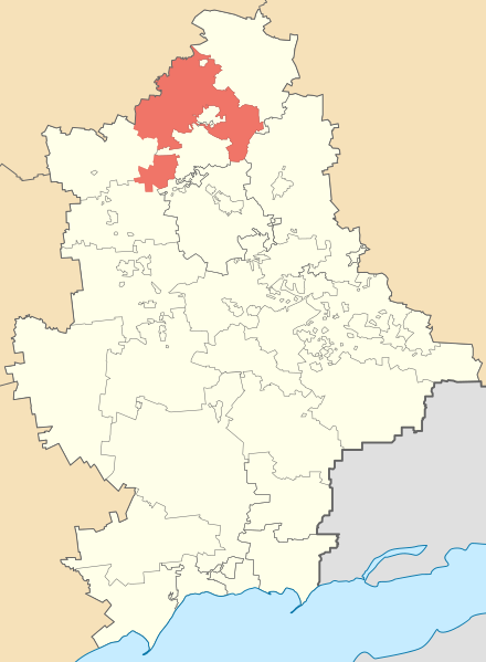
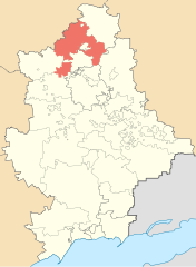
Русский: Карта-локатор Славянского района Донецкой области, Украина
Українська: Карта-локатор Слов'янського району Донецької області, Україна
English: Locator map of Slovyansk raion (district) of Donetsk oblast (province), Ukraine |
| Date | |
| Source | Own work |
| Author | Артемко |
Licensing
| I, the copyright holder of this work, release this work into the
public domain. This applies worldwide. In some countries this may not be legally possible; if so: I grant anyone the right to use this work for any purpose, without any conditions, unless such conditions are required by law. |
File history
Click on a date/time to view the file as it appeared at that time.
| Date/Time | Thumbnail | Dimensions | User | Comment | |
|---|---|---|---|---|---|
| current | 19:42, 15 March 2017 |
| 489 × 666 (68 KB) | Artemco | Николаевка |
| 09:51, 15 October 2015 |
 | 489 × 666 (70 KB) | Artemco | convention colors and more accurate borders | |
| 10:00, 15 June 2015 |
 | 489 × 666 (83 KB) | Artemco | уточнены границы | |
| 11:09, 29 May 2015 |
 | 489 × 666 (81 KB) | Artemco | уточнены границы | |
| 06:55, 11 January 2011 |
 | 531 × 725 (321 KB) | Urutseg |
File usage
The following pages on the English Wikipedia use this file (pages on other projects are not listed):
Global file usage
The following other wikis use this file:
- Usage on be-tarask.wikipedia.org
- Usage on be.wikipedia.org
- Usage on cs.wikipedia.org
- Usage on de.wikipedia.org
- Usage on es.wikipedia.org
- Usage on eu.wikipedia.org
- Usage on fi.wikipedia.org
- Usage on hy.wikipedia.org
- Usage on it.wikipedia.org
- Usage on ka.wikipedia.org
- Usage on pl.wikipedia.org
- Usage on ru.wikipedia.org
- Usage on sco.wikipedia.org
- Usage on uk.wikipedia.org
- Usage on uk.wikisource.org
- Usage on www.wikidata.org
- Usage on zh-min-nan.wikipedia.org
- Usage on zh.wikipedia.org
Metadata
Size of this PNG preview of this SVG file:
440 × 599 pixels. Other resolutions:
176 × 240 pixels |
352 × 480 pixels |
564 × 768 pixels |
752 × 1,024 pixels |
1,504 × 2,048 pixels |
489 × 666 pixels.
Original file (SVG file, nominally 489 × 666 pixels, file size: 68 KB)
| This is a file from the
Wikimedia Commons. Information from its
description page there is shown below. Commons is a freely licensed media file repository. You can help. |
Summary
| Description |
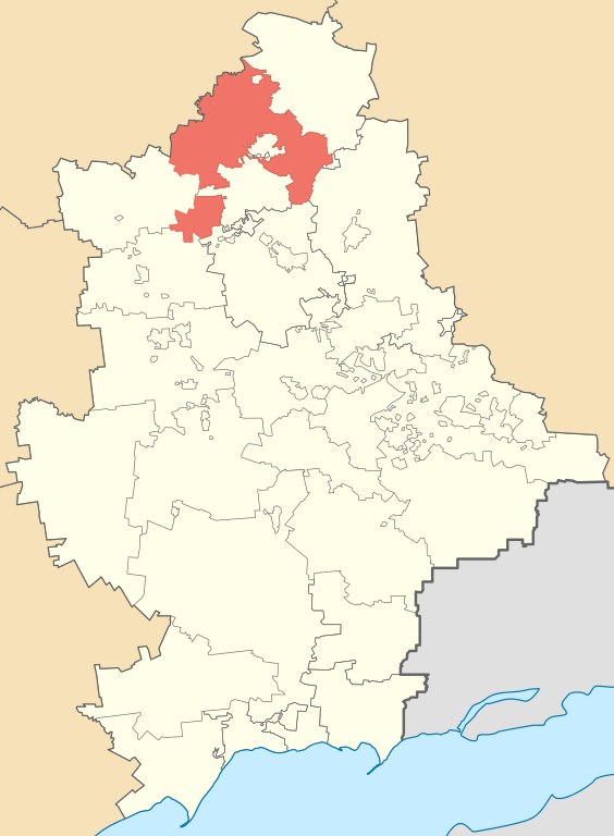
Русский: Карта-локатор Славянского района Донецкой области, Украина
Українська: Карта-локатор Слов'янського району Донецької області, Україна
English: Locator map of Slovyansk raion (district) of Donetsk oblast (province), Ukraine |
| Date | |
| Source | Own work |
| Author | Артемко |
Licensing
| I, the copyright holder of this work, release this work into the
public domain. This applies worldwide. In some countries this may not be legally possible; if so: I grant anyone the right to use this work for any purpose, without any conditions, unless such conditions are required by law. |
File history
Click on a date/time to view the file as it appeared at that time.
| Date/Time | Thumbnail | Dimensions | User | Comment | |
|---|---|---|---|---|---|
| current | 19:42, 15 March 2017 |
| 489 × 666 (68 KB) | Artemco | Николаевка |
| 09:51, 15 October 2015 |
| 489 × 666 (70 KB) | Artemco | convention colors and more accurate borders | |
| 10:00, 15 June 2015 |
| 489 × 666 (83 KB) | Artemco | уточнены границы | |
| 11:09, 29 May 2015 |
| 489 × 666 (81 KB) | Artemco | уточнены границы | |
| 06:55, 11 January 2011 |
| 531 × 725 (321 KB) | Urutseg |
File usage
The following pages on the English Wikipedia use this file (pages on other projects are not listed):
Global file usage
The following other wikis use this file:
- Usage on be-tarask.wikipedia.org
- Usage on be.wikipedia.org
- Usage on cs.wikipedia.org
- Usage on de.wikipedia.org
- Usage on es.wikipedia.org
- Usage on eu.wikipedia.org
- Usage on fi.wikipedia.org
- Usage on hy.wikipedia.org
- Usage on it.wikipedia.org
- Usage on ka.wikipedia.org
- Usage on pl.wikipedia.org
- Usage on ru.wikipedia.org
- Usage on sco.wikipedia.org
- Usage on uk.wikipedia.org
- Usage on uk.wikisource.org
- Usage on www.wikidata.org
- Usage on zh-min-nan.wikipedia.org
- Usage on zh.wikipedia.org