
Size of this PNG preview of this SVG file:
255 × 267 pixels. Other resolutions:
229 × 240 pixels |
458 × 480 pixels |
733 × 768 pixels |
978 × 1,024 pixels |
1,956 × 2,048 pixels.
Original file (SVG file, nominally 255 × 267 pixels, file size: 58 KB)
| This is a file from the
Wikimedia Commons. Information from its
description page there is shown below. Commons is a freely licensed media file repository. You can help. |
W3C-validity not checked.
| Description |
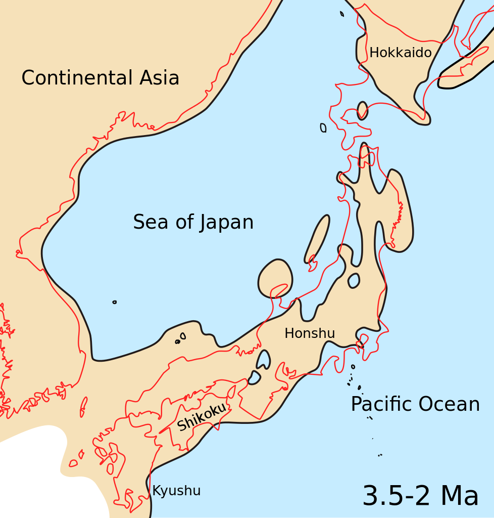
English: Map showing Japanese archipelago, Sea of Japan and surrounding part of continental East Asia in Middle Pliocene to Late Pliocene (3.5-2 Ma, 3.5-2 million years ago). |
| Date | |
| Source | Kameda Y. & Kato M. (2011). "Terrestrial invasion of pomatiopsid gastropods in the heavy-snow region of the Japanese Archipelago". BMC Evolutionary Biology 11: 118. doi:10.1186/1471-2148-11-118. Figure 5C. Modified: added color of ocean. |
| Author | Yuichi Kameda & Makoto Kato |
| Other versions |
Derivative works of this file: Sea of Japan Pliocene map He.jpg |


This file is licensed under the
Creative Commons
Attribution 2.0 Generic license.
- You are free:
- to share – to copy, distribute and transmit the work
- to remix – to adapt the work
- Under the following conditions:
- attribution – You must give appropriate credit, provide a link to the license, and indicate if changes were made. You may do so in any reasonable manner, but not in any way that suggests the licensor endorses you or your use.
File history
Click on a date/time to view the file as it appeared at that time.
| Date/Time | Thumbnail | Dimensions | User | Comment | |
|---|---|---|---|---|---|
| current | 01:07, 2 October 2012 |
| 255 × 267 (58 KB) | Ciaurlec | Colours uniformed to other palaeomaps |
| 16:17, 21 July 2011 |
 | 255 × 267 (56 KB) | Snek01 | {{validSVG}} {{Information |Description={{en|Map showing Japanese archipelago, Sea of Japan and surrounding part of continental East Asia in Middle Pliocene to Late Pliocene (3.5-2 Ma).}} |Source=Kameda Y. & Kato M. (2011). "Terrestrial invasion of pomati |
File usage
The following pages on the English Wikipedia use this file (pages on other projects are not listed):
Global file usage
The following other wikis use this file:
- Usage on bg.wikipedia.org
- Usage on ca.wikipedia.org
- Usage on cs.wikipedia.org
- Usage on gl.wikipedia.org
- Usage on id.wikipedia.org
- Usage on io.wikipedia.org
- Usage on ja.wikipedia.org
- Usage on ko.wikipedia.org
- Usage on outreach.wikimedia.org
- Usage on pl.wikipedia.org
- Usage on pt.wikipedia.org
- Usage on ro.wikipedia.org
- Usage on ru.wikipedia.org
- Usage on sl.wikipedia.org
- Usage on ta.wikipedia.org
- Usage on th.wikipedia.org
- Usage on uk.wikipedia.org
- Usage on vi.wikipedia.org
Metadata
Size of this PNG preview of this SVG file:
255 × 267 pixels. Other resolutions:
229 × 240 pixels |
458 × 480 pixels |
733 × 768 pixels |
978 × 1,024 pixels |
1,956 × 2,048 pixels.
Original file (SVG file, nominally 255 × 267 pixels, file size: 58 KB)
| This is a file from the
Wikimedia Commons. Information from its
description page there is shown below. Commons is a freely licensed media file repository. You can help. |
W3C-validity not checked.
| Description |
English: Map showing Japanese archipelago, Sea of Japan and surrounding part of continental East Asia in Middle Pliocene to Late Pliocene (3.5-2 Ma, 3.5-2 million years ago). |
| Date | |
| Source | Kameda Y. & Kato M. (2011). "Terrestrial invasion of pomatiopsid gastropods in the heavy-snow region of the Japanese Archipelago". BMC Evolutionary Biology 11: 118. doi:10.1186/1471-2148-11-118. Figure 5C. Modified: added color of ocean. |
| Author | Yuichi Kameda & Makoto Kato |
| Other versions |
Derivative works of this file: Sea of Japan Pliocene map He.jpg |
This file is licensed under the
Creative Commons
Attribution 2.0 Generic license.
- You are free:
- to share – to copy, distribute and transmit the work
- to remix – to adapt the work
- Under the following conditions:
- attribution – You must give appropriate credit, provide a link to the license, and indicate if changes were made. You may do so in any reasonable manner, but not in any way that suggests the licensor endorses you or your use.
File history
Click on a date/time to view the file as it appeared at that time.
| Date/Time | Thumbnail | Dimensions | User | Comment | |
|---|---|---|---|---|---|
| current | 01:07, 2 October 2012 |
| 255 × 267 (58 KB) | Ciaurlec | Colours uniformed to other palaeomaps |
| 16:17, 21 July 2011 |
| 255 × 267 (56 KB) | Snek01 | {{validSVG}} {{Information |Description={{en|Map showing Japanese archipelago, Sea of Japan and surrounding part of continental East Asia in Middle Pliocene to Late Pliocene (3.5-2 Ma).}} |Source=Kameda Y. & Kato M. (2011). "Terrestrial invasion of pomati |
File usage
The following pages on the English Wikipedia use this file (pages on other projects are not listed):
Global file usage
The following other wikis use this file:
- Usage on bg.wikipedia.org
- Usage on ca.wikipedia.org
- Usage on cs.wikipedia.org
- Usage on gl.wikipedia.org
- Usage on id.wikipedia.org
- Usage on io.wikipedia.org
- Usage on ja.wikipedia.org
- Usage on ko.wikipedia.org
- Usage on outreach.wikimedia.org
- Usage on pl.wikipedia.org
- Usage on pt.wikipedia.org
- Usage on ro.wikipedia.org
- Usage on ru.wikipedia.org
- Usage on sl.wikipedia.org
- Usage on ta.wikipedia.org
- Usage on th.wikipedia.org
- Usage on uk.wikipedia.org
- Usage on vi.wikipedia.org