
Original file (1,134 × 858 pixels, file size: 340 KB, MIME type: image/jpeg)
| This is a file from the
Wikimedia Commons. Information from its
description page there is shown below. Commons is a freely licensed media file repository. You can help. |
Summary
| Description |
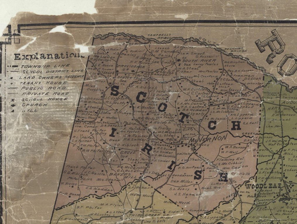
English: Shows roads, township boundaries, schools, churches, home owners and renters |
| Date | |
| Source |
Found at the Rowan County GIS Website on the Internet https://gisdata-rowancountync.opendata.arcgis.com/documents/1903-map/explore |
| Author | Published by C M Miller, Salisbury, Rowan County, North Carolina in 1907 |
| Camera location |
| View this and other nearby images on: OpenStreetMap |
|
|---|
Scotch Irish Township, Rowan County, North Carolina, United States
Licensing
|
This work is in the public domain in its country of origin and other countries and areas where the copyright term is the author's life plus 70 years or fewer. This work is in the public domain in the United States because it was published (or registered with the U.S. Copyright Office) before January 1, 1929. | |
| This file has been identified as being free of known restrictions under copyright law, including all related and neighboring rights. | |
File history
Click on a date/time to view the file as it appeared at that time.
| Date/Time | Thumbnail | Dimensions | User | Comment | |
|---|---|---|---|---|---|
| current | 13:42, 29 June 2022 |
| 1,134 × 858 (340 KB) | G. Moore | Uploaded a work by Published by C M Miller, Salisbury, Rowan County, North Carolina in 1907 from Found at the Rowan County GIS Website on the Internet https://gisdata-rowancountync.opendata.arcgis.com/documents/1903-map/explore with UploadWizard |
File usage
Original file (1,134 × 858 pixels, file size: 340 KB, MIME type: image/jpeg)
| This is a file from the
Wikimedia Commons. Information from its
description page there is shown below. Commons is a freely licensed media file repository. You can help. |
Summary
| Description |
English: Shows roads, township boundaries, schools, churches, home owners and renters |
| Date | |
| Source |
Found at the Rowan County GIS Website on the Internet https://gisdata-rowancountync.opendata.arcgis.com/documents/1903-map/explore |
| Author | Published by C M Miller, Salisbury, Rowan County, North Carolina in 1907 |
| Camera location |
| View this and other nearby images on: OpenStreetMap |
|
|---|
Scotch Irish Township, Rowan County, North Carolina, United States
Licensing
|
This work is in the public domain in its country of origin and other countries and areas where the copyright term is the author's life plus 70 years or fewer. This work is in the public domain in the United States because it was published (or registered with the U.S. Copyright Office) before January 1, 1929. | |
| This file has been identified as being free of known restrictions under copyright law, including all related and neighboring rights. | |
File history
Click on a date/time to view the file as it appeared at that time.
| Date/Time | Thumbnail | Dimensions | User | Comment | |
|---|---|---|---|---|---|
| current | 13:42, 29 June 2022 |
| 1,134 × 858 (340 KB) | G. Moore | Uploaded a work by Published by C M Miller, Salisbury, Rowan County, North Carolina in 1907 from Found at the Rowan County GIS Website on the Internet https://gisdata-rowancountync.opendata.arcgis.com/documents/1903-map/explore with UploadWizard |