
Original file (SVG file, nominally 1,957 × 2,306 pixels, file size: 1.27 MB)
| This is a file from the
Wikimedia Commons. Information from its
description page there is shown below. Commons is a freely licensed media file repository. You can help. |
Summary
| Description |
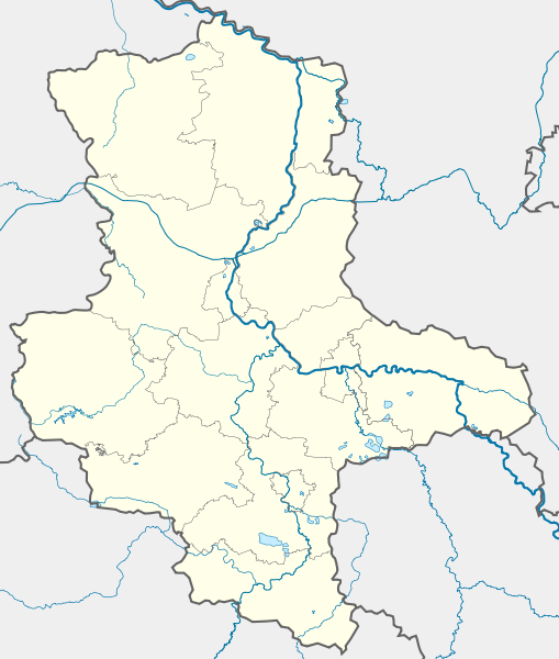
Deutsch: Positionskarte
Sachsen-Anhalt, Deutschland. Geographische Begrenzung der Karte:
English: Location map
Saxony-Anhalt, Germany. Geographic limits of the map:
|
| Date | |
| Source |
own work, templates |
| Author | TUBS |
| Other versions |
Derivative works of this file: Karte VTO 2012 under CC-by-sa.png
|

|
|
Open this image as an overlay in Google Earth ( Google Maps, Bing) | ( Help| Source) |
Licensing

|
Permission is granted to copy, distribute and/or modify this document under the terms of the GNU Free Documentation License, Version 1.2 or any later version published by the Free Software Foundation; with no Invariant Sections, no Front-Cover Texts, and no Back-Cover Texts. A copy of the license is included in the section entitled GNU Free Documentation License. |
- You are free:
- to share – to copy, distribute and transmit the work
- to remix – to adapt the work
- Under the following conditions:
- attribution – You must give appropriate credit, provide a link to the license, and indicate if changes were made. You may do so in any reasonable manner, but not in any way that suggests the licensor endorses you or your use.
- share alike – If you remix, transform, or build upon the material, you must distribute your contributions under the same or compatible license as the original.
File history
Click on a date/time to view the file as it appeared at that time.
| Date/Time | Thumbnail | Dimensions | User | Comment | |
|---|---|---|---|---|---|
| current | 17:14, 22 September 2009 |
| 1,957 × 2,306 (1.27 MB) | Alexrk2 | Darstellungsreihenfolge Flüsse,Seen |
| 16:15, 22 September 2009 |
 | 1,957 × 2,306 (1.26 MB) | Alexrk2 | Landesgrenze korr. | |
| 09:26, 2 February 2009 |
 | 1,957 × 2,306 (875 KB) | TUBS | rivers aside district borders. +Wasserstraßenkreuz Magdeburg | |
| 01:22, 31 January 2009 |
 | 1,957 × 2,306 (872 KB) | TUBS | corrected some rivers outside state of Saxony-Anhalt | |
| 22:07, 29 January 2009 |
 | 1,957 × 2,306 (845 KB) | TUBS | thinner stroke weights | |
| 21:46, 29 January 2009 |
 | 1,957 × 2,306 (845 KB) | TUBS | == Summary == {{Information |Description= {{de|Positionskarte Sachsen-Anhalt, Deutschland. Geographische Begrenzung der Karte:}} {{en|Location map Saxony-Anhalt, Germany. Geographic limits of the map:}} * N: |
File usage
More than 100 pages use this file. The following list shows the first 100 pages that use this file only. A full list is available.
- Aken (Elbe)
- Alexisbad
- Arendsee
- Aschersleben
- Bad Kösen
- Bad Lauchstädt
- Bad Suderode
- Ballenstedt
- Bernburg
- Bismark, Germany
- Blankenburg (Harz)
- Burg bei Magdeburg
- Calbe
- Colbitz
- Coswig, Saxony-Anhalt
- Dankerode
- Dessau
- Ditfurt
- Dönitz
- Egeln
- Eisleben
- Erxleben, Stendal
- Falkenstein, Saxony-Anhalt
- Friedrichsbrunn
- Gardelegen
- Gerbstedt
- Gernrode
- Goseck
- Greifenhagen
- Gröningen
- Güntersberge
- Halberstadt
- Haldensleben
- Halle (Saale)
- Harzgerode
- Hausneindorf
- Havelberg
- Hecklingen
- Hedersleben, Harz
- Heeren
- Heteborn
- Hettstedt
- Hoym
- Huysburg
- Ilsenburg
- Ilsenburg Abbey
- Kalbe, Saxony-Anhalt
- Klötze
- Königerode
- Königsborn
- Königsburg
- Köthen
- Landsberg, Saxony-Anhalt
- Leppin
- Leuna
- Lindau (Anhalt)
- Loburg
- Lützen
- Magdeburg
- Mellin
- Merseburg
- Naumburg
- Nebra (Unstrut)
- Neinstedt
- Nienburg, Saxony-Anhalt
- Oebisfelde
- Oranienbaum, Germany
- Oschersleben
- Quedlinburg
- Querfurt
- Radegast
- Radisleben
- Rieder
- Riesigk
- Roßlau
- Rudelsburg
- Röcken
- Sachau
- Sack of Magdeburg
- Salzwedel
- Sangerhausen
- Schielo
- Schönebeck
- Seeland, Germany
- Staßfurt
- Stendal
- Straßberg, Saxony-Anhalt
- Ströbeck
- Tangermünde
- Thale
- Trebnitz
- Weddersleben
- Wedderstedt
- Weißenfels
- Welfesholz
- Wernigerode
- Wettin, Saxony-Anhalt
- Wittenberg
- Wolmirstedt
- Wörlitz
View more links to this file.
Global file usage
The following other wikis use this file:
- Usage on ar.wikipedia.org
- Usage on azb.wikipedia.org
- Usage on ba.wikipedia.org
- Цербст (ҡала)
- Дессау
- Виттенберг
- Вернигероде
- Кётен
- Ильзенбург (Гарц)
- Плёцкау
- Хойккевальде
- Хакеборн
- Либехна
- Шёнебек (Эльба)
- Вольферштедт
- Кольбиц
- Фрисдорф
- Зиштедт
- Зальцмюнде
- Офельгюнне
- Коббельсдорф
- Цетлинген
- Шлагентин
- Илевиц
- Гольдшау
- Хаймбург
- Бухгольц (Альтмарк)
- Веспен (Бёрде)
- Шоллене
- Рагун
- Хельбра
- Кверфурт (Германиялағы ҡала)
- Гросмюлинген
- Веддерслебен
- Кюттен (Саксония-Анхальт)
- Хоэнтрам
- Таугвиц
- Хедерслебен (Мансфельд)
- Кальбе (Заале)
- Карсдорф
- Ауслебен
- Зоммерсдорф
- Зеебенау
- Дёбрис
- Заубах
- Хеклинген
- Цимендорф
- Турланд
- Харслебен
View more global usage of this file.
Original file (SVG file, nominally 1,957 × 2,306 pixels, file size: 1.27 MB)
| This is a file from the
Wikimedia Commons. Information from its
description page there is shown below. Commons is a freely licensed media file repository. You can help. |
Summary
| Description |
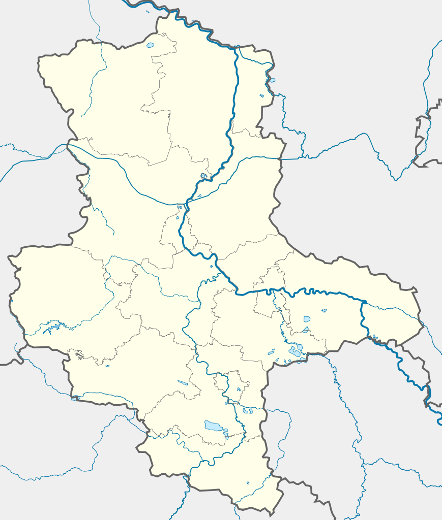
Deutsch: Positionskarte
Sachsen-Anhalt, Deutschland. Geographische Begrenzung der Karte:
English: Location map
Saxony-Anhalt, Germany. Geographic limits of the map:
|
| Date | |
| Source |
own work, templates |
| Author | TUBS |
| Other versions |
Derivative works of this file: Karte VTO 2012 under CC-by-sa.png
|
|
|
Open this image as an overlay in Google Earth ( Google Maps, Bing) | ( Help| Source) |
Licensing
|
|
Permission is granted to copy, distribute and/or modify this document under the terms of the GNU Free Documentation License, Version 1.2 or any later version published by the Free Software Foundation; with no Invariant Sections, no Front-Cover Texts, and no Back-Cover Texts. A copy of the license is included in the section entitled GNU Free Documentation License. |
- You are free:
- to share – to copy, distribute and transmit the work
- to remix – to adapt the work
- Under the following conditions:
- attribution – You must give appropriate credit, provide a link to the license, and indicate if changes were made. You may do so in any reasonable manner, but not in any way that suggests the licensor endorses you or your use.
- share alike – If you remix, transform, or build upon the material, you must distribute your contributions under the same or compatible license as the original.
File history
Click on a date/time to view the file as it appeared at that time.
| Date/Time | Thumbnail | Dimensions | User | Comment | |
|---|---|---|---|---|---|
| current | 17:14, 22 September 2009 |
| 1,957 × 2,306 (1.27 MB) | Alexrk2 | Darstellungsreihenfolge Flüsse,Seen |
| 16:15, 22 September 2009 |
| 1,957 × 2,306 (1.26 MB) | Alexrk2 | Landesgrenze korr. | |
| 09:26, 2 February 2009 |
| 1,957 × 2,306 (875 KB) | TUBS | rivers aside district borders. +Wasserstraßenkreuz Magdeburg | |
| 01:22, 31 January 2009 |
| 1,957 × 2,306 (872 KB) | TUBS | corrected some rivers outside state of Saxony-Anhalt | |
| 22:07, 29 January 2009 |
| 1,957 × 2,306 (845 KB) | TUBS | thinner stroke weights | |
| 21:46, 29 January 2009 |
| 1,957 × 2,306 (845 KB) | TUBS | == Summary == {{Information |Description= {{de|Positionskarte Sachsen-Anhalt, Deutschland. Geographische Begrenzung der Karte:}} {{en|Location map Saxony-Anhalt, Germany. Geographic limits of the map:}} * N: |
File usage
More than 100 pages use this file. The following list shows the first 100 pages that use this file only. A full list is available.
- Aken (Elbe)
- Alexisbad
- Arendsee
- Aschersleben
- Bad Kösen
- Bad Lauchstädt
- Bad Suderode
- Ballenstedt
- Bernburg
- Bismark, Germany
- Blankenburg (Harz)
- Burg bei Magdeburg
- Calbe
- Colbitz
- Coswig, Saxony-Anhalt
- Dankerode
- Dessau
- Ditfurt
- Dönitz
- Egeln
- Eisleben
- Erxleben, Stendal
- Falkenstein, Saxony-Anhalt
- Friedrichsbrunn
- Gardelegen
- Gerbstedt
- Gernrode
- Goseck
- Greifenhagen
- Gröningen
- Güntersberge
- Halberstadt
- Haldensleben
- Halle (Saale)
- Harzgerode
- Hausneindorf
- Havelberg
- Hecklingen
- Hedersleben, Harz
- Heeren
- Heteborn
- Hettstedt
- Hoym
- Huysburg
- Ilsenburg
- Ilsenburg Abbey
- Kalbe, Saxony-Anhalt
- Klötze
- Königerode
- Königsborn
- Königsburg
- Köthen
- Landsberg, Saxony-Anhalt
- Leppin
- Leuna
- Lindau (Anhalt)
- Loburg
- Lützen
- Magdeburg
- Mellin
- Merseburg
- Naumburg
- Nebra (Unstrut)
- Neinstedt
- Nienburg, Saxony-Anhalt
- Oebisfelde
- Oranienbaum, Germany
- Oschersleben
- Quedlinburg
- Querfurt
- Radegast
- Radisleben
- Rieder
- Riesigk
- Roßlau
- Rudelsburg
- Röcken
- Sachau
- Sack of Magdeburg
- Salzwedel
- Sangerhausen
- Schielo
- Schönebeck
- Seeland, Germany
- Staßfurt
- Stendal
- Straßberg, Saxony-Anhalt
- Ströbeck
- Tangermünde
- Thale
- Trebnitz
- Weddersleben
- Wedderstedt
- Weißenfels
- Welfesholz
- Wernigerode
- Wettin, Saxony-Anhalt
- Wittenberg
- Wolmirstedt
- Wörlitz
View more links to this file.
Global file usage
The following other wikis use this file:
- Usage on ar.wikipedia.org
- Usage on azb.wikipedia.org
- Usage on ba.wikipedia.org
- Цербст (ҡала)
- Дессау
- Виттенберг
- Вернигероде
- Кётен
- Ильзенбург (Гарц)
- Плёцкау
- Хойккевальде
- Хакеборн
- Либехна
- Шёнебек (Эльба)
- Вольферштедт
- Кольбиц
- Фрисдорф
- Зиштедт
- Зальцмюнде
- Офельгюнне
- Коббельсдорф
- Цетлинген
- Шлагентин
- Илевиц
- Гольдшау
- Хаймбург
- Бухгольц (Альтмарк)
- Веспен (Бёрде)
- Шоллене
- Рагун
- Хельбра
- Кверфурт (Германиялағы ҡала)
- Гросмюлинген
- Веддерслебен
- Кюттен (Саксония-Анхальт)
- Хоэнтрам
- Таугвиц
- Хедерслебен (Мансфельд)
- Кальбе (Заале)
- Карсдорф
- Ауслебен
- Зоммерсдорф
- Зеебенау
- Дёбрис
- Заубах
- Хеклинген
- Цимендорф
- Турланд
- Харслебен
View more global usage of this file.