
Saudi_map_of_Persian_gulf_1952.jpg (623 × 442 pixels, file size: 127 KB, MIME type: image/jpeg)
| This is a file from the
Wikimedia Commons. Information from its
description page there is shown below. Commons is a freely licensed media file repository. You can help. |
Summary
| Description |
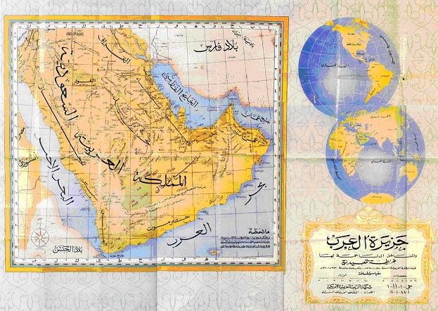
English: Map of the Arabian Peninsula, 1952, showing, in Arabic, the name "Persian Gulf" for the body of water to the north-east
مصرى: الخليج العربي |
| Date | |
| Source | http://www.kavehfarrokh.com/wp-content/uploads/2009/02/map-of-persian-gulf-published-by-saudi-arabia-19523.jpg |
| Author | Arabian government |
| Permission ( Reusing this file) |
Public domain under Arabian copyright law |
|
This is a faithful photographic reproduction of a two-dimensional,
public domain work of art. The work of art itself is in the public domain for the following reason:
The official position taken by the Wikimedia Foundation is that "faithful reproductions of two-dimensional public domain works of art are public domain". This photographic reproduction is therefore also considered to be in the public domain in the United States. In other jurisdictions, re-use of this content may be restricted; see Reuse of PD-Art photographs for details.
{{PD-Art}} template without license parameter: please specify why the underlying work is public domain in both the source country and the United States
(Usage: {{PD-Art|1=|deathyear=''year of author's death''|country=''source country''}}, where parameter 1= can be PD-old-auto, PD-old-auto-expired, PD-old-auto-1996, PD-old-100 or similar. See Commons:Multi-license copyright tags for more information.) | ||||
File history
Click on a date/time to view the file as it appeared at that time.
| Date/Time | Thumbnail | Dimensions | User | Comment | |
|---|---|---|---|---|---|
| current | 18:30, 20 March 2009 |
| 623 × 442 (127 KB) | David Trochos | {{Information |Description={{en|1=Map of the Arabian Peninsula, 1952, showing, in Arabic, the name "Persian Gulf" for the body of water to the north-east}} |Source=http://www.kavehfarrokh.com/wp-content/uploads/2009/02/map-of-persian-gulf-published-by-sau |
File usage
Global file usage
The following other wikis use this file:
- Usage on ar.wikipedia.org
- Usage on arz.wikipedia.org
- Usage on de.wikipedia.org
- Usage on diq.wikipedia.org
- Usage on fa.wikipedia.org
- Usage on fa.wikibooks.org
- Usage on glk.wikipedia.org
- Usage on hi.wikipedia.org
- Usage on hr.wikipedia.org
- Usage on it.wikipedia.org
- Usage on ja.wikipedia.org
- Usage on ko.wikipedia.org
- Usage on mzn.wikipedia.org
- Usage on pnb.wikipedia.org
- Usage on ro.wikipedia.org
- Usage on ru.wikipedia.org
- Usage on sh.wikipedia.org
- Usage on uk.wikipedia.org
- Usage on ur.wikipedia.org
- Usage on zh.wikipedia.org
Metadata
Saudi_map_of_Persian_gulf_1952.jpg (623 × 442 pixels, file size: 127 KB, MIME type: image/jpeg)
| This is a file from the
Wikimedia Commons. Information from its
description page there is shown below. Commons is a freely licensed media file repository. You can help. |
Summary
| Description |
English: Map of the Arabian Peninsula, 1952, showing, in Arabic, the name "Persian Gulf" for the body of water to the north-east
مصرى: الخليج العربي |
| Date | |
| Source | http://www.kavehfarrokh.com/wp-content/uploads/2009/02/map-of-persian-gulf-published-by-saudi-arabia-19523.jpg |
| Author | Arabian government |
| Permission ( Reusing this file) |
Public domain under Arabian copyright law |
|
This is a faithful photographic reproduction of a two-dimensional,
public domain work of art. The work of art itself is in the public domain for the following reason:
The official position taken by the Wikimedia Foundation is that "faithful reproductions of two-dimensional public domain works of art are public domain". This photographic reproduction is therefore also considered to be in the public domain in the United States. In other jurisdictions, re-use of this content may be restricted; see Reuse of PD-Art photographs for details.
{{PD-Art}} template without license parameter: please specify why the underlying work is public domain in both the source country and the United States
(Usage: {{PD-Art|1=|deathyear=''year of author's death''|country=''source country''}}, where parameter 1= can be PD-old-auto, PD-old-auto-expired, PD-old-auto-1996, PD-old-100 or similar. See Commons:Multi-license copyright tags for more information.) | ||||
File history
Click on a date/time to view the file as it appeared at that time.
| Date/Time | Thumbnail | Dimensions | User | Comment | |
|---|---|---|---|---|---|
| current | 18:30, 20 March 2009 |
| 623 × 442 (127 KB) | David Trochos | {{Information |Description={{en|1=Map of the Arabian Peninsula, 1952, showing, in Arabic, the name "Persian Gulf" for the body of water to the north-east}} |Source=http://www.kavehfarrokh.com/wp-content/uploads/2009/02/map-of-persian-gulf-published-by-sau |
File usage
Global file usage
The following other wikis use this file:
- Usage on ar.wikipedia.org
- Usage on arz.wikipedia.org
- Usage on de.wikipedia.org
- Usage on diq.wikipedia.org
- Usage on fa.wikipedia.org
- Usage on fa.wikibooks.org
- Usage on glk.wikipedia.org
- Usage on hi.wikipedia.org
- Usage on hr.wikipedia.org
- Usage on it.wikipedia.org
- Usage on ja.wikipedia.org
- Usage on ko.wikipedia.org
- Usage on mzn.wikipedia.org
- Usage on pnb.wikipedia.org
- Usage on ro.wikipedia.org
- Usage on ru.wikipedia.org
- Usage on sh.wikipedia.org
- Usage on uk.wikipedia.org
- Usage on ur.wikipedia.org
- Usage on zh.wikipedia.org