No higher resolution available.
SantaIsabelmap.png (495 × 487 pixels, file size: 12 KB, MIME type: image/png)
| This is a file from the
Wikimedia Commons. Information from its
description page there is shown below. Commons is a freely licensed media file repository. You can help. |
| Description |
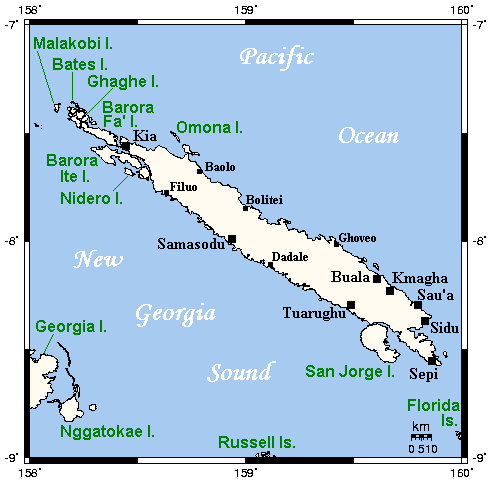
English: Map of Santa Isabel and neighbouring islands in the Solomon Islands.
Русский: Карта острова Санта-Исабель в архипелаге Соломоновы острова и близлежащих островов. |
||||||||
| Date | Originally uploaded to en:Wikipedia ( log) in April 2006 by Kelisi ( talk). | ||||||||
| Source | English Wikipedia en:Image:SantaIsabelmap.png | ||||||||
| Author | This map's source is here, with the uploader's modifications, and the GMT homepage says that the tools are released under the GNU General Public License. | ||||||||
| Permission ( Reusing this file) |
original text: {{GFDL-self-with-disclaimers}}
|

File history
Click on a date/time to view the file as it appeared at that time.
| Date/Time | Thumbnail | Dimensions | User | Comment | |
|---|---|---|---|---|---|
| current | 19:59, 3 March 2008 |
| 495 × 487 (12 KB) | Переход Артур | {{Information |Description={{en|Map of Santa Isabel and neighbouring islands in the Solomon Islands.}} {{ru|Карта острова Санта-Исабель в архипелаге Соломоновы острова и близлежащих остр� |
File usage
The following pages on the English Wikipedia use this file (pages on other projects are not listed):
Global file usage
The following other wikis use this file:
- Usage on ast.wikipedia.org
- Usage on bg.wikipedia.org
- Usage on ceb.wikipedia.org
- Usage on cs.wikipedia.org
- Usage on de.wikipedia.org
- Usage on es.wikipedia.org
- Usage on et.wikipedia.org
- Usage on fa.wikipedia.org
- Usage on fr.wikipedia.org
- Usage on gl.wikipedia.org
- Usage on hr.wikipedia.org
- Usage on id.wikipedia.org
- Usage on it.wikipedia.org
- Usage on ja.wikipedia.org
- Usage on ka.wikipedia.org
- Usage on ko.wikipedia.org
- Usage on nl.wikipedia.org
- Usage on no.wikipedia.org
- Usage on ru.wikipedia.org
- Usage on uk.wikipedia.org
- Usage on ur.wikipedia.org
- Usage on vi.wikipedia.org
- Usage on www.wikidata.org
- Usage on zh.wikipedia.org
No higher resolution available.
SantaIsabelmap.png (495 × 487 pixels, file size: 12 KB, MIME type: image/png)
| This is a file from the
Wikimedia Commons. Information from its
description page there is shown below. Commons is a freely licensed media file repository. You can help. |
| Description |
English: Map of Santa Isabel and neighbouring islands in the Solomon Islands.
Русский: Карта острова Санта-Исабель в архипелаге Соломоновы острова и близлежащих островов. |
||||||||
| Date | Originally uploaded to en:Wikipedia ( log) in April 2006 by Kelisi ( talk). | ||||||||
| Source | English Wikipedia en:Image:SantaIsabelmap.png | ||||||||
| Author | This map's source is here, with the uploader's modifications, and the GMT homepage says that the tools are released under the GNU General Public License. | ||||||||
| Permission ( Reusing this file) |
original text: {{GFDL-self-with-disclaimers}}
|
File history
Click on a date/time to view the file as it appeared at that time.
| Date/Time | Thumbnail | Dimensions | User | Comment | |
|---|---|---|---|---|---|
| current | 19:59, 3 March 2008 |
| 495 × 487 (12 KB) | Переход Артур | {{Information |Description={{en|Map of Santa Isabel and neighbouring islands in the Solomon Islands.}} {{ru|Карта острова Санта-Исабель в архипелаге Соломоновы острова и близлежащих остр� |
File usage
The following pages on the English Wikipedia use this file (pages on other projects are not listed):
Global file usage
The following other wikis use this file:
- Usage on ast.wikipedia.org
- Usage on bg.wikipedia.org
- Usage on ceb.wikipedia.org
- Usage on cs.wikipedia.org
- Usage on de.wikipedia.org
- Usage on es.wikipedia.org
- Usage on et.wikipedia.org
- Usage on fa.wikipedia.org
- Usage on fr.wikipedia.org
- Usage on gl.wikipedia.org
- Usage on hr.wikipedia.org
- Usage on id.wikipedia.org
- Usage on it.wikipedia.org
- Usage on ja.wikipedia.org
- Usage on ka.wikipedia.org
- Usage on ko.wikipedia.org
- Usage on nl.wikipedia.org
- Usage on no.wikipedia.org
- Usage on ru.wikipedia.org
- Usage on uk.wikipedia.org
- Usage on ur.wikipedia.org
- Usage on vi.wikipedia.org
- Usage on www.wikidata.org
- Usage on zh.wikipedia.org