
Size of this PNG preview of this SVG file:
263 × 599 pixels. Other resolutions:
105 × 240 pixels |
211 × 480 pixels |
337 × 768 pixels |
450 × 1,024 pixels |
900 × 2,048 pixels |
290 × 660 pixels.
Original file (SVG file, nominally 290 × 660 pixels, file size: 76 KB)
| This is a file from the
Wikimedia Commons. Information from its
description page there is shown below. Commons is a freely licensed media file repository. You can help. |
| Description |
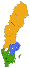
English: A map of the NUTS 1 (Lands) and NUTS 2 (National areas) subdivisions of Sweden since 2008. The colour shows which Land a particular National area belongs to.
Svenska: Sveriges Landsdelar (NUTS 1) och Riksområde (NUTS 2) sedan 2008. Färgerna anger vilken Landsdel ett riksområde tillhör.
East Sweden
South Sweden
North Sweden |
| Date | |
| Source |
Made by Lokal_Profil
|
| Author | Lokal_Profil |
| Permission ( Reusing this file) |
This file is licensed under the
Creative Commons
Attribution-Share Alike 2.5 Generic license. Attribution:
Lokal_Profil
|
File history
Click on a date/time to view the file as it appeared at that time.
| Date/Time | Thumbnail | Dimensions | User | Comment | |
|---|---|---|---|---|---|
| current | 19:52, 20 May 2010 |
| 290 × 660 (76 KB) | Lokal Profil | {{Information |Description={{en|A map of the NUTS 1 (Lands) and NUTS 2 (National areas) subdivisions of Sweden since 2008. The colour shows which Land a particular National area belongs to.}} {{sv|Sveriges Landsdelar (NUTS 1) och Riksområde (NUTS 2) seda |
File usage
The following pages on the English Wikipedia use this file (pages on other projects are not listed):
Global file usage
The following other wikis use this file:
- Usage on bs.wikipedia.org
- Usage on fi.wikipedia.org
- Usage on pt.wikipedia.org
- Usage on sl.wikipedia.org
- Usage on sv.wikipedia.org
- Usage on tr.wikipedia.org
- Usage on uk.wikipedia.org
- Usage on zh.wikipedia.org
Size of this PNG preview of this SVG file:
263 × 599 pixels. Other resolutions:
105 × 240 pixels |
211 × 480 pixels |
337 × 768 pixels |
450 × 1,024 pixels |
900 × 2,048 pixels |
290 × 660 pixels.
Original file (SVG file, nominally 290 × 660 pixels, file size: 76 KB)
| This is a file from the
Wikimedia Commons. Information from its
description page there is shown below. Commons is a freely licensed media file repository. You can help. |
| Description |
English: A map of the NUTS 1 (Lands) and NUTS 2 (National areas) subdivisions of Sweden since 2008. The colour shows which Land a particular National area belongs to.
Svenska: Sveriges Landsdelar (NUTS 1) och Riksområde (NUTS 2) sedan 2008. Färgerna anger vilken Landsdel ett riksområde tillhör.
East Sweden
South Sweden
North Sweden |
| Date | |
| Source |
Made by Lokal_Profil
|
| Author | Lokal_Profil |
| Permission ( Reusing this file) |
This file is licensed under the
Creative Commons
Attribution-Share Alike 2.5 Generic license. Attribution:
Lokal_Profil
|
File history
Click on a date/time to view the file as it appeared at that time.
| Date/Time | Thumbnail | Dimensions | User | Comment | |
|---|---|---|---|---|---|
| current | 19:52, 20 May 2010 |
| 290 × 660 (76 KB) | Lokal Profil | {{Information |Description={{en|A map of the NUTS 1 (Lands) and NUTS 2 (National areas) subdivisions of Sweden since 2008. The colour shows which Land a particular National area belongs to.}} {{sv|Sveriges Landsdelar (NUTS 1) och Riksområde (NUTS 2) seda |
File usage
The following pages on the English Wikipedia use this file (pages on other projects are not listed):
Global file usage
The following other wikis use this file:
- Usage on bs.wikipedia.org
- Usage on fi.wikipedia.org
- Usage on pt.wikipedia.org
- Usage on sl.wikipedia.org
- Usage on sv.wikipedia.org
- Usage on tr.wikipedia.org
- Usage on uk.wikipedia.org
- Usage on zh.wikipedia.org