No higher resolution available.
SR-30_guide_number_69.jpg (185 × 428 pixels, file size: 14 KB, MIME type: image/jpeg)
| This is a file from the
Wikimedia Commons. Information from its
description page there is shown below. Commons is a freely licensed media file repository. You can help. |
This file is in the
public domain because it comes from the Utah Supplement to the
Manual on Uniform Traffic Control Devices, sign number GS1-4a. The
Utah Supplement states on page I-1 that:
|
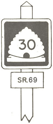
This shows how the SR-30 "state signed guide number" was signed along State Statutory Route 69 in the U.S. state of Utah from 1966 to 1977. It is cropped and modified from Image:SR-30 guide number.jpg.
File history
Click on a date/time to view the file as it appeared at that time.
| Date/Time | Thumbnail | Dimensions | User | Comment | |
|---|---|---|---|---|---|
| current | 08:06, 26 July 2007 |
| 185 × 428 (14 KB) | NE2 | {{PD-ineligible}} This shows how the SR-30 "state signed guide number" was signed along State Statutory Route 69 in the U.S. state of Utah from 1966 to 1977. It is cropped and modified from Image:SR-30 guide number.jpg. [[Category:Utah State Route s |
File usage
The following pages on the English Wikipedia use this file (pages on other projects are not listed):
Metadata
No higher resolution available.
SR-30_guide_number_69.jpg (185 × 428 pixels, file size: 14 KB, MIME type: image/jpeg)
| This is a file from the
Wikimedia Commons. Information from its
description page there is shown below. Commons is a freely licensed media file repository. You can help. |
This file is in the
public domain because it comes from the Utah Supplement to the
Manual on Uniform Traffic Control Devices, sign number GS1-4a. The
Utah Supplement states on page I-1 that:
|
This shows how the SR-30 "state signed guide number" was signed along State Statutory Route 69 in the U.S. state of Utah from 1966 to 1977. It is cropped and modified from Image:SR-30 guide number.jpg.
File history
Click on a date/time to view the file as it appeared at that time.
| Date/Time | Thumbnail | Dimensions | User | Comment | |
|---|---|---|---|---|---|
| current | 08:06, 26 July 2007 |
| 185 × 428 (14 KB) | NE2 | {{PD-ineligible}} This shows how the SR-30 "state signed guide number" was signed along State Statutory Route 69 in the U.S. state of Utah from 1966 to 1977. It is cropped and modified from Image:SR-30 guide number.jpg. [[Category:Utah State Route s |
File usage
The following pages on the English Wikipedia use this file (pages on other projects are not listed):