Photos • Location


Size of this preview:
800 × 588 pixels. Other resolutions:
320 × 235 pixels |
640 × 470 pixels |
1,024 × 752 pixels |
1,280 × 940 pixels |
2,560 × 1,880 pixels |
4,223 × 3,102 pixels.
Original file (4,223 × 3,102 pixels, file size: 7.66 MB, MIME type: image/jpeg)
| This is a file from the
Wikimedia Commons. Information from its
description page there is shown below. Commons is a freely licensed media file repository. You can help. |
| Description |
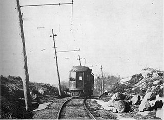
English: A Shore Line Electric Railway (SLERy) trolley at Madison in 1911. Route 1 was later built along this section of the trolley right-of-way; this curve is just east of the intersection with Signal Hill Road and Liberty Street (the original Post Road route). |
||
| Date | |||
| Source | Scanned from Connecticut Railroads: An Illustrated History | ||
| Author | Unknown author | ||
| Permission ( Reusing this file) |
|
| Camera location | | View this and other nearby images on: OpenStreetMap |
|
|---|
File history
Click on a date/time to view the file as it appeared at that time.
| Date/Time | Thumbnail | Dimensions | User | Comment | |
|---|---|---|---|---|---|
| current | 20:47, 7 January 2014 |
| 4,223 × 3,102 (7.66 MB) | Pi.1415926535 | {{Information |Description={{en|1=A Shore Line Electric Railway (SLERy) trolley at Madison in 1911. Route 1 was later built along this section of the trolley right-of-way; this curve is just east of the intersection with Signal Hill Road and Liberty St... |
File usage
The following pages on the English Wikipedia use this file (pages on other projects are not listed):
Global file usage
The following other wikis use this file:
- Usage on www.wikidata.org
Metadata
Size of this preview:
800 × 588 pixels. Other resolutions:
320 × 235 pixels |
640 × 470 pixels |
1,024 × 752 pixels |
1,280 × 940 pixels |
2,560 × 1,880 pixels |
4,223 × 3,102 pixels.
Original file (4,223 × 3,102 pixels, file size: 7.66 MB, MIME type: image/jpeg)
| This is a file from the
Wikimedia Commons. Information from its
description page there is shown below. Commons is a freely licensed media file repository. You can help. |
| Description |
English: A Shore Line Electric Railway (SLERy) trolley at Madison in 1911. Route 1 was later built along this section of the trolley right-of-way; this curve is just east of the intersection with Signal Hill Road and Liberty Street (the original Post Road route). |
||
| Date | |||
| Source | Scanned from Connecticut Railroads: An Illustrated History | ||
| Author | Unknown author | ||
| Permission ( Reusing this file) |
|
| Camera location | | View this and other nearby images on: OpenStreetMap |
|
|---|
File history
Click on a date/time to view the file as it appeared at that time.
| Date/Time | Thumbnail | Dimensions | User | Comment | |
|---|---|---|---|---|---|
| current | 20:47, 7 January 2014 |
| 4,223 × 3,102 (7.66 MB) | Pi.1415926535 | {{Information |Description={{en|1=A Shore Line Electric Railway (SLERy) trolley at Madison in 1911. Route 1 was later built along this section of the trolley right-of-way; this curve is just east of the intersection with Signal Hill Road and Liberty St... |
File usage
The following pages on the English Wikipedia use this file (pages on other projects are not listed):
Global file usage
The following other wikis use this file:
- Usage on www.wikidata.org