
Size of this preview:
474 × 600 pixels. Other resolutions:
190 × 240 pixels |
475 × 601 pixels.
Original file (475 × 601 pixels, file size: 15 KB, MIME type: image/png)
| This is a file from the
Wikimedia Commons. Information from its
description page there is shown below. Commons is a freely licensed media file repository. You can help. |
Summary
| Description |
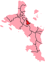
English: Map of Mahe Island, Seychelles showing Les Mamelles District; created with the GIMP. Made by
User:Acntx. |
| Date | 19 January 2006 (original upload date) |
| Source | Transferred from en.wikipedia to Commons by Egs using CommonsHelper. |
| Author | Acntx at English Wikipedia |
Licensing
Acntx at the
English-language Wikipedia, the copyright holder of this work, hereby publishes it under the following license:
| This file is licensed under the Creative Commons Attribution-Share Alike 3.0 Unported license. Subject to disclaimers. | ||
| Attribution: Acntx at the English-language Wikipedia | ||
| ||
| This licensing tag was added to this file as part of the GFDL licensing update. |

|
Permission is granted to copy, distribute and/or modify this document under the terms of the GNU Free Documentation License, Version 1.2 or any later version published by the Free Software Foundation; with no Invariant Sections, no Front-Cover Texts, and no Back-Cover Texts. A copy of the license is included in the section entitled GNU Free Documentation License. Subject to disclaimers. |
Original upload log
The original description page was
here. All following user names refer to en.wikipedia.
- 2006-01-19 23:35 Acntx 457×601×8 (8263 bytes)
File history
Click on a date/time to view the file as it appeared at that time.
| Date/Time | Thumbnail | Dimensions | User | Comment | |
|---|---|---|---|---|---|
| current | 19:21, 16 December 2009 |
| 475 × 601 (15 KB) | Acntx | Map Correction |
| 11:19, 15 June 2008 |
 | 457 × 601 (8 KB) | File Upload Bot (Magnus Manske) | {{BotMoveToCommons|en.wikipedia}} {{Information |Description={{en|Map of Mahe Island, Seychelles showing Les Mamelles District; created with the GIMP. Made by en:User:Acntx.}} |Source=Transferred from [http://en.wikipedia.org en.wikipedia]; transfer |
File usage
The following pages on the English Wikipedia use this file (pages on other projects are not listed):
Global file usage
The following other wikis use this file:
- Usage on ca.wikipedia.org
- Usage on fa.wikipedia.org
- Usage on he.wikipedia.org
- Usage on id.wikipedia.org
- Usage on ka.wikipedia.org
- Usage on ko.wikipedia.org
- Usage on ms.wikipedia.org
- Usage on nl.wikipedia.org
- Usage on pl.wikipedia.org
- Usage on pt.wikipedia.org
- Usage on ro.wikipedia.org
- Usage on sv.wikipedia.org
- Usage on ur.wikipedia.org
- Usage on www.wikidata.org
- Usage on zh.wikipedia.org
Size of this preview:
474 × 600 pixels. Other resolutions:
190 × 240 pixels |
475 × 601 pixels.
Original file (475 × 601 pixels, file size: 15 KB, MIME type: image/png)
| This is a file from the
Wikimedia Commons. Information from its
description page there is shown below. Commons is a freely licensed media file repository. You can help. |
Summary
| Description |
English: Map of Mahe Island, Seychelles showing Les Mamelles District; created with the GIMP. Made by
User:Acntx. |
| Date | 19 January 2006 (original upload date) |
| Source | Transferred from en.wikipedia to Commons by Egs using CommonsHelper. |
| Author | Acntx at English Wikipedia |
Licensing
Acntx at the
English-language Wikipedia, the copyright holder of this work, hereby publishes it under the following license:
| This file is licensed under the Creative Commons Attribution-Share Alike 3.0 Unported license. Subject to disclaimers. | ||
| Attribution: Acntx at the English-language Wikipedia | ||
| ||
| This licensing tag was added to this file as part of the GFDL licensing update. |
|
|
Permission is granted to copy, distribute and/or modify this document under the terms of the GNU Free Documentation License, Version 1.2 or any later version published by the Free Software Foundation; with no Invariant Sections, no Front-Cover Texts, and no Back-Cover Texts. A copy of the license is included in the section entitled GNU Free Documentation License. Subject to disclaimers. |
Original upload log
The original description page was
here. All following user names refer to en.wikipedia.
- 2006-01-19 23:35 Acntx 457×601×8 (8263 bytes)
File history
Click on a date/time to view the file as it appeared at that time.
| Date/Time | Thumbnail | Dimensions | User | Comment | |
|---|---|---|---|---|---|
| current | 19:21, 16 December 2009 |
| 475 × 601 (15 KB) | Acntx | Map Correction |
| 11:19, 15 June 2008 |
| 457 × 601 (8 KB) | File Upload Bot (Magnus Manske) | {{BotMoveToCommons|en.wikipedia}} {{Information |Description={{en|Map of Mahe Island, Seychelles showing Les Mamelles District; created with the GIMP. Made by en:User:Acntx.}} |Source=Transferred from [http://en.wikipedia.org en.wikipedia]; transfer |
File usage
The following pages on the English Wikipedia use this file (pages on other projects are not listed):
Global file usage
The following other wikis use this file:
- Usage on ca.wikipedia.org
- Usage on fa.wikipedia.org
- Usage on he.wikipedia.org
- Usage on id.wikipedia.org
- Usage on ka.wikipedia.org
- Usage on ko.wikipedia.org
- Usage on ms.wikipedia.org
- Usage on nl.wikipedia.org
- Usage on pl.wikipedia.org
- Usage on pt.wikipedia.org
- Usage on ro.wikipedia.org
- Usage on sv.wikipedia.org
- Usage on ur.wikipedia.org
- Usage on www.wikidata.org
- Usage on zh.wikipedia.org