
Original file (4,272 × 2,848 pixels, file size: 7.33 MB, MIME type: image/jpeg)
| This is a file from the
Wikimedia Commons. Information from its
description page there is shown below. Commons is a freely licensed media file repository. You can help. |
.jpg)
Summary
| Description |
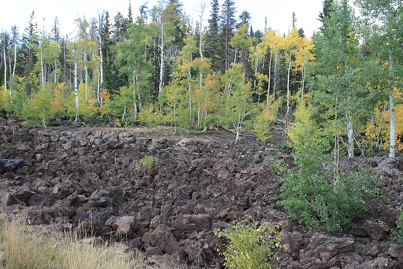
The Markagunt Plateau is an 800-square-mile (2,100 km2) plateau located in southwestern Utah between Interstate 15 and U.S. Route 89. It is one of the plateaus that make up the High Plateaus Section of the Colorado Plateau Province. The name is derived from a Piute word meaning "Highland of Trees". The plateau encompasses Cedar Breaks National Monument, and is part of the Cedar Mountain District of Dixie National Forest. The highest point on the plateau is Brian Head Peak at 11,307 feet (3,446 m). The Markagunt Plateau volcanic field is an area of basaltic cinder cones and blocky lava flows. The most recent flows occurred around 1050 CE and were preceded by a series of trachytic, andesitic and rhyolitic lava. The field lies east of Cedar Breaks National Monument. Navajo Lake was formed when a lava flow dammed a creek on the plateau. The youngest features of the Markagunt Plateau volcanic field are blocky unvegetated lava flows known locally as the 'Black Rock Desert.' They extend from near Miller Knoll on to the southeast. These flows also extend northeast to near Panguitch Lake. <a href=" http://en.wikipedia.org/wiki/Markagunt_Plateau" >en.wikipedia.org/wiki/Markagunt_Plateau</a> <a href=" http://en.wikipedia.org/wiki/Wikipedia:Text_of_Creative_Commons_Attribution-ShareAlike_3.0_Unported_License" >en.wikipedia.org/wiki/Wikipedia:Text_of_Creative_Commons_...</a> |
| Date | Taken on 19 September 2009, 14:07 |
| Source | S.R. 14 Lava Flow, Near Duck Creek, Utah |
| Author | Ken Lund from Reno, Nevada, USA |
| Camera location |
| View this and other nearby images on: OpenStreetMap |
|
|---|
.jpg¶ms=037.524630_N_-112.742718_E_globe:Earth_type:camera_source:Flickr_&language=en)
Licensing
- You are free:
- to share – to copy, distribute and transmit the work
- to remix – to adapt the work
- Under the following conditions:
- attribution – You must give appropriate credit, provide a link to the license, and indicate if changes were made. You may do so in any reasonable manner, but not in any way that suggests the licensor endorses you or your use.
- share alike – If you remix, transform, or build upon the material, you must distribute your contributions under the same or compatible license as the original.
| This image was originally posted to Flickr by Ken Lund at https://flickr.com/photos/75683070@N00/3943437970 ( archive). It was reviewed on 7 August 2019 by FlickreviewR 2 and was confirmed to be licensed under the terms of the cc-by-sa-2.0. |
File history
Click on a date/time to view the file as it appeared at that time.
| Date/Time | Thumbnail | Dimensions | User | Comment | |
|---|---|---|---|---|---|
| current | 14:12, 7 August 2019 |
| 4,272 × 2,848 (7.33 MB) | Jo-Jo Eumerus | Transferred from Flickr via #flickr2commons |
File usage
Metadata
.jpg)
Original file (4,272 × 2,848 pixels, file size: 7.33 MB, MIME type: image/jpeg)
| This is a file from the
Wikimedia Commons. Information from its
description page there is shown below. Commons is a freely licensed media file repository. You can help. |
Summary
| Description |
The Markagunt Plateau is an 800-square-mile (2,100 km2) plateau located in southwestern Utah between Interstate 15 and U.S. Route 89. It is one of the plateaus that make up the High Plateaus Section of the Colorado Plateau Province. The name is derived from a Piute word meaning "Highland of Trees". The plateau encompasses Cedar Breaks National Monument, and is part of the Cedar Mountain District of Dixie National Forest. The highest point on the plateau is Brian Head Peak at 11,307 feet (3,446 m). The Markagunt Plateau volcanic field is an area of basaltic cinder cones and blocky lava flows. The most recent flows occurred around 1050 CE and were preceded by a series of trachytic, andesitic and rhyolitic lava. The field lies east of Cedar Breaks National Monument. Navajo Lake was formed when a lava flow dammed a creek on the plateau. The youngest features of the Markagunt Plateau volcanic field are blocky unvegetated lava flows known locally as the 'Black Rock Desert.' They extend from near Miller Knoll on to the southeast. These flows also extend northeast to near Panguitch Lake. <a href=" http://en.wikipedia.org/wiki/Markagunt_Plateau" >en.wikipedia.org/wiki/Markagunt_Plateau</a> <a href=" http://en.wikipedia.org/wiki/Wikipedia:Text_of_Creative_Commons_Attribution-ShareAlike_3.0_Unported_License" >en.wikipedia.org/wiki/Wikipedia:Text_of_Creative_Commons_...</a> |
| Date | Taken on 19 September 2009, 14:07 |
| Source | S.R. 14 Lava Flow, Near Duck Creek, Utah |
| Author | Ken Lund from Reno, Nevada, USA |
| Camera location |
| View this and other nearby images on: OpenStreetMap |
|
|---|
Licensing
- You are free:
- to share – to copy, distribute and transmit the work
- to remix – to adapt the work
- Under the following conditions:
- attribution – You must give appropriate credit, provide a link to the license, and indicate if changes were made. You may do so in any reasonable manner, but not in any way that suggests the licensor endorses you or your use.
- share alike – If you remix, transform, or build upon the material, you must distribute your contributions under the same or compatible license as the original.
| This image was originally posted to Flickr by Ken Lund at https://flickr.com/photos/75683070@N00/3943437970 ( archive). It was reviewed on 7 August 2019 by FlickreviewR 2 and was confirmed to be licensed under the terms of the cc-by-sa-2.0. |
File history
Click on a date/time to view the file as it appeared at that time.
| Date/Time | Thumbnail | Dimensions | User | Comment | |
|---|---|---|---|---|---|
| current | 14:12, 7 August 2019 |
| 4,272 × 2,848 (7.33 MB) | Jo-Jo Eumerus | Transferred from Flickr via #flickr2commons |