Size of this preview:
800 × 600 pixels. Other resolutions:
320 × 240 pixels |
640 × 480 pixels |
1,024 × 768 pixels |
1,280 × 960 pixels |
1,600 × 1,200 pixels.
Original file (1,600 × 1,200 pixels, file size: 561 KB, MIME type: image/jpeg)
| This is a file from the
Wikimedia Commons. Information from its
description page there is shown below. Commons is a freely licensed media file repository. You can help. |
Summary
| Description |
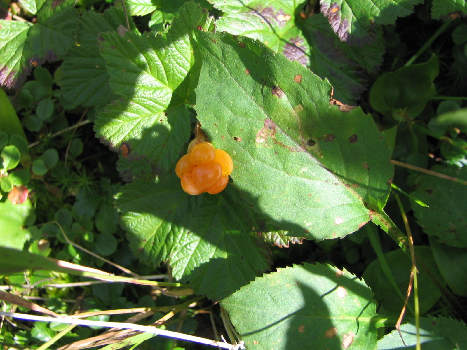
English: 49° 01' 27.2" N - 65° 52' 56.3" W, Gaspésie-Îles-de-la-Madeleine, Haute-Gaspésie, Gaspésie National Park, Mont-Albert, Mont Jacques-Cartier, Sunday August 15, 2004 , geolocation at the campsite
Français : 49° 01' 27.2" N - 65° 52' 56.3" O, Gaspésie-Îles-de-la-Madeleine, Haute-Gaspésie, Parc national de la Gaspésie, Mont-Albert, mont Jacques-Cartier, le dimanche 15 août 2004, géolocalisation au camping |
| Date | |
| Source | Own work |
| Author | Nichole Ouellette/ouellette001.com |
— Végétation des rivages maritimes froids du Québec
- Rubus chamaemorus Linné. — Ronce petit-mûrier. — Mûres blanches, Blackbières, Plaquebières, Chicoutés. — (Cloudberry).
- Élément principal de la forêt laurentienne Picea glauca (Moench) Voss. — Épicéa glauque. — Épinette blanche. — (White spruce).
- Ledum groenlandicum Retzius. — Lédon du Groenland. — Thé du Labrador, Thé velouté. — (Labrador Tea).
- Élément principal de la forêt laurentienne Picea glauca (Moench) Voss. — Épicéa glauque. — Épinette blanche. — (White spruce).
- Habitats nordiques de la route 138, à Havre-Saint-Pierre
- Orchidées - campanules - linaires - épilobes à Havre-Saint-Pierre
- Flore autour du golfe du Saint-Laurent : Anticosti, Minganie et les Îles-de-la-Madeleine (index)
- Same author: florelaurentienne.com/ ouellette001.com
Licensing
I, the copyright holder of this work, hereby publish it under the following license:
This file is licensed under the
Creative Commons
Attribution 4.0 International license.
- You are free:
- to share – to copy, distribute and transmit the work
- to remix – to adapt the work
- Under the following conditions:
- attribution – You must give appropriate credit, provide a link to the license, and indicate if changes were made. You may do so in any reasonable manner, but not in any way that suggests the licensor endorses you or your use.
File history
Click on a date/time to view the file as it appeared at that time.
| Date/Time | Thumbnail | Dimensions | User | Comment | |
|---|---|---|---|---|---|
| current | 03:42, 9 July 2024 |
| 1,600 × 1,200 (561 KB) | Nichole Ouellette | Uploaded own work with UploadWizard |
File usage
The following pages on the English Wikipedia use this file (pages on other projects are not listed):
Global file usage
The following other wikis use this file:
- Usage on fr.wikipedia.org
Metadata
Size of this preview:
800 × 600 pixels. Other resolutions:
320 × 240 pixels |
640 × 480 pixels |
1,024 × 768 pixels |
1,280 × 960 pixels |
1,600 × 1,200 pixels.
Original file (1,600 × 1,200 pixels, file size: 561 KB, MIME type: image/jpeg)
| This is a file from the
Wikimedia Commons. Information from its
description page there is shown below. Commons is a freely licensed media file repository. You can help. |
Summary
| Description |
English: 49° 01' 27.2" N - 65° 52' 56.3" W, Gaspésie-Îles-de-la-Madeleine, Haute-Gaspésie, Gaspésie National Park, Mont-Albert, Mont Jacques-Cartier, Sunday August 15, 2004 , geolocation at the campsite
Français : 49° 01' 27.2" N - 65° 52' 56.3" O, Gaspésie-Îles-de-la-Madeleine, Haute-Gaspésie, Parc national de la Gaspésie, Mont-Albert, mont Jacques-Cartier, le dimanche 15 août 2004, géolocalisation au camping |
| Date | |
| Source | Own work |
| Author | Nichole Ouellette/ouellette001.com |
— Végétation des rivages maritimes froids du Québec
- Rubus chamaemorus Linné. — Ronce petit-mûrier. — Mûres blanches, Blackbières, Plaquebières, Chicoutés. — (Cloudberry).
- Élément principal de la forêt laurentienne Picea glauca (Moench) Voss. — Épicéa glauque. — Épinette blanche. — (White spruce).
- Ledum groenlandicum Retzius. — Lédon du Groenland. — Thé du Labrador, Thé velouté. — (Labrador Tea).
- Élément principal de la forêt laurentienne Picea glauca (Moench) Voss. — Épicéa glauque. — Épinette blanche. — (White spruce).
- Habitats nordiques de la route 138, à Havre-Saint-Pierre
- Orchidées - campanules - linaires - épilobes à Havre-Saint-Pierre
- Flore autour du golfe du Saint-Laurent : Anticosti, Minganie et les Îles-de-la-Madeleine (index)
- Same author: florelaurentienne.com/ ouellette001.com
Licensing
I, the copyright holder of this work, hereby publish it under the following license:
This file is licensed under the
Creative Commons
Attribution 4.0 International license.
- You are free:
- to share – to copy, distribute and transmit the work
- to remix – to adapt the work
- Under the following conditions:
- attribution – You must give appropriate credit, provide a link to the license, and indicate if changes were made. You may do so in any reasonable manner, but not in any way that suggests the licensor endorses you or your use.
File history
Click on a date/time to view the file as it appeared at that time.
| Date/Time | Thumbnail | Dimensions | User | Comment | |
|---|---|---|---|---|---|
| current | 03:42, 9 July 2024 |
| 1,600 × 1,200 (561 KB) | Nichole Ouellette | Uploaded own work with UploadWizard |
File usage
The following pages on the English Wikipedia use this file (pages on other projects are not listed):
Global file usage
The following other wikis use this file:
- Usage on fr.wikipedia.org