
Original file (SVG file, nominally 1,425 × 1,400 pixels, file size: 3.04 MB)
| This is a file from the
Wikimedia Commons. Information from its
description page there is shown below. Commons is a freely licensed media file repository. You can help. |
| Description |
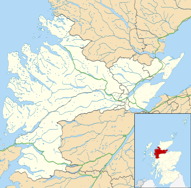
Map of Ross and Cromarty, UK in 2011, with the following information shown:
Equirectangular map projection on WGS 84 datum, with N/S stretched 180% Geographic limits:
|
| Date | |
| Source |
|
| Author | Nilfanion, created using Ordnance Survey data |
| Permission ( Reusing this file) |
This file is licensed under the
Creative Commons
Attribution-Share Alike 3.0 Unported license. Attribution: Contains Ordnance Survey data © Crown copyright and database right
|
| Other versions | File:Ross and Cromarty UK blank map.svg - Blank map |
File history
Click on a date/time to view the file as it appeared at that time.
| Date/Time | Thumbnail | Dimensions | User | Comment | |
|---|---|---|---|---|---|
| current | 23:31, 4 March 2011 |
| 1,425 × 1,400 (3.04 MB) | Nilfanion | {{Information |Description=Map of Ross and Cromarty, UK in 2011, with the following information shown: *Ward boundaries *Coastline and lakes *Roads and railways *Urban areas Equirectangular map projection on WGS 84 datum, with N/S |
File usage
More than 100 pages use this file. The following list shows the first 100 pages that use this file only. A full list is available.
- Achanalt
- Achandunie
- Achduart
- Achiltibuie
- Achintraid
- Alcaig
- Alness
- Applecross
- Arabella, Highland
- Ardarroch
- Ardcharnich
- Ardindrean
- Ardross, Highland
- Arnisdale
- Arpafeelie
- Artafallie
- Auchindrean
- Auchtertyre
- Badcaul
- Balmacara
- Camas Luinie
- Camusnagaul
- Camusteel
- Camusterrach
- Carnach
- Coigach
- Conon Bridge
- Contin
- Corran, Loch Hourn
- Coulags
- Croftnacreich
- Cromarty
- Culbokie
- Culduie
- Cullicudden
- Delny
- Dingwall
- Dornie
- Duirinish, Lochalsh
- Duncanston
- Dundonnell
- Edderton
- Erbusaig
- Evanton
- Fodderty
- Fortrose
- Gairloch
- Garve
- Glenelg, Highland
- Gorstan
- HMS Fieldfare
- Hill of Fearn
- Hilton of Cadboll
- Inver, Highland
- Inveralligin
- Inverchoran
- Invergordon
- Inverinate
- Jamestown, Easter Ross
- Jemimaville
- Kildary
- Killilan
- Kinlochewe
- Knockfarrel
- Kyle of Lochalsh
- Laide
- Lamington, Highland
- Leckmelm
- Letterfearn
- Letters, Wester Ross
- Loch Kishorn
- Lochcarron
- Lochslin
- Londubh
- Lonemore, Wester Ross
- Maryburgh
- Mellon Charles
- Mellon Udrigle
- Milton, Easter Ross
- Morefield
- Morvich, Highland
- Mountgerald
- Muir of Ord
- Munlochy
- Newfield, Highland
- Nigg, Highland
- North Kessock
- Poolewe
- Portmahomack
- Rosemarkie
- Sallachy
- Saltburn, Ross and Cromarty
- Sand, Highland
- Scoraig
- Shieldaig
- Strathcarron, Highland
- Strathkanaird
- Strathpeffer
- Ullapool
- Urray
View more links to this file.
Global file usage
The following other wikis use this file:
- Usage on ar.wikipedia.org
- Usage on be.wikipedia.org
- Usage on br.wikipedia.org
- Usage on ceb.wikipedia.org
- Usage on es.wikipedia.org
- Usage on fa.wikipedia.org
- Usage on fr.wikipedia.org
- Usage on ja.wikipedia.org
- Usage on kn.wikipedia.org
- Usage on sco.wikipedia.org
- Usage on si.wikipedia.org
- Usage on tr.wikipedia.org
- Usage on uz.wikipedia.org
- Usage on war.wikipedia.org
Metadata
Original file (SVG file, nominally 1,425 × 1,400 pixels, file size: 3.04 MB)
| This is a file from the
Wikimedia Commons. Information from its
description page there is shown below. Commons is a freely licensed media file repository. You can help. |
| Description |
Map of Ross and Cromarty, UK in 2011, with the following information shown:
Equirectangular map projection on WGS 84 datum, with N/S stretched 180% Geographic limits:
|
| Date | |
| Source |
|
| Author | Nilfanion, created using Ordnance Survey data |
| Permission ( Reusing this file) |
This file is licensed under the
Creative Commons
Attribution-Share Alike 3.0 Unported license. Attribution: Contains Ordnance Survey data © Crown copyright and database right
|
| Other versions | File:Ross and Cromarty UK blank map.svg - Blank map |
File history
Click on a date/time to view the file as it appeared at that time.
| Date/Time | Thumbnail | Dimensions | User | Comment | |
|---|---|---|---|---|---|
| current | 23:31, 4 March 2011 |
| 1,425 × 1,400 (3.04 MB) | Nilfanion | {{Information |Description=Map of Ross and Cromarty, UK in 2011, with the following information shown: *Ward boundaries *Coastline and lakes *Roads and railways *Urban areas Equirectangular map projection on WGS 84 datum, with N/S |
File usage
More than 100 pages use this file. The following list shows the first 100 pages that use this file only. A full list is available.
- Achanalt
- Achandunie
- Achduart
- Achiltibuie
- Achintraid
- Alcaig
- Alness
- Applecross
- Arabella, Highland
- Ardarroch
- Ardcharnich
- Ardindrean
- Ardross, Highland
- Arnisdale
- Arpafeelie
- Artafallie
- Auchindrean
- Auchtertyre
- Badcaul
- Balmacara
- Camas Luinie
- Camusnagaul
- Camusteel
- Camusterrach
- Carnach
- Coigach
- Conon Bridge
- Contin
- Corran, Loch Hourn
- Coulags
- Croftnacreich
- Cromarty
- Culbokie
- Culduie
- Cullicudden
- Delny
- Dingwall
- Dornie
- Duirinish, Lochalsh
- Duncanston
- Dundonnell
- Edderton
- Erbusaig
- Evanton
- Fodderty
- Fortrose
- Gairloch
- Garve
- Glenelg, Highland
- Gorstan
- HMS Fieldfare
- Hill of Fearn
- Hilton of Cadboll
- Inver, Highland
- Inveralligin
- Inverchoran
- Invergordon
- Inverinate
- Jamestown, Easter Ross
- Jemimaville
- Kildary
- Killilan
- Kinlochewe
- Knockfarrel
- Kyle of Lochalsh
- Laide
- Lamington, Highland
- Leckmelm
- Letterfearn
- Letters, Wester Ross
- Loch Kishorn
- Lochcarron
- Lochslin
- Londubh
- Lonemore, Wester Ross
- Maryburgh
- Mellon Charles
- Mellon Udrigle
- Milton, Easter Ross
- Morefield
- Morvich, Highland
- Mountgerald
- Muir of Ord
- Munlochy
- Newfield, Highland
- Nigg, Highland
- North Kessock
- Poolewe
- Portmahomack
- Rosemarkie
- Sallachy
- Saltburn, Ross and Cromarty
- Sand, Highland
- Scoraig
- Shieldaig
- Strathcarron, Highland
- Strathkanaird
- Strathpeffer
- Ullapool
- Urray
View more links to this file.
Global file usage
The following other wikis use this file:
- Usage on ar.wikipedia.org
- Usage on be.wikipedia.org
- Usage on br.wikipedia.org
- Usage on ceb.wikipedia.org
- Usage on es.wikipedia.org
- Usage on fa.wikipedia.org
- Usage on fr.wikipedia.org
- Usage on ja.wikipedia.org
- Usage on kn.wikipedia.org
- Usage on sco.wikipedia.org
- Usage on si.wikipedia.org
- Usage on tr.wikipedia.org
- Usage on uz.wikipedia.org
- Usage on war.wikipedia.org