
Size of this PNG preview of this SVG file:
800 × 457 pixels. Other resolutions:
320 × 183 pixels |
640 × 366 pixels |
1,024 × 585 pixels |
1,280 × 732 pixels |
2,560 × 1,463 pixels |
1,732 × 990 pixels.
Original file (SVG file, nominally 1,732 × 990 pixels, file size: 757 KB)
| This is a file from the
Wikimedia Commons. Information from its
description page there is shown below. Commons is a freely licensed media file repository. You can help. |
Summary
| Description |
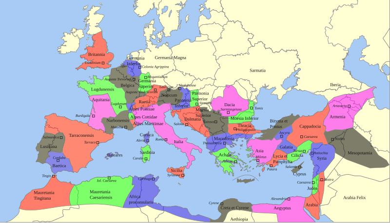
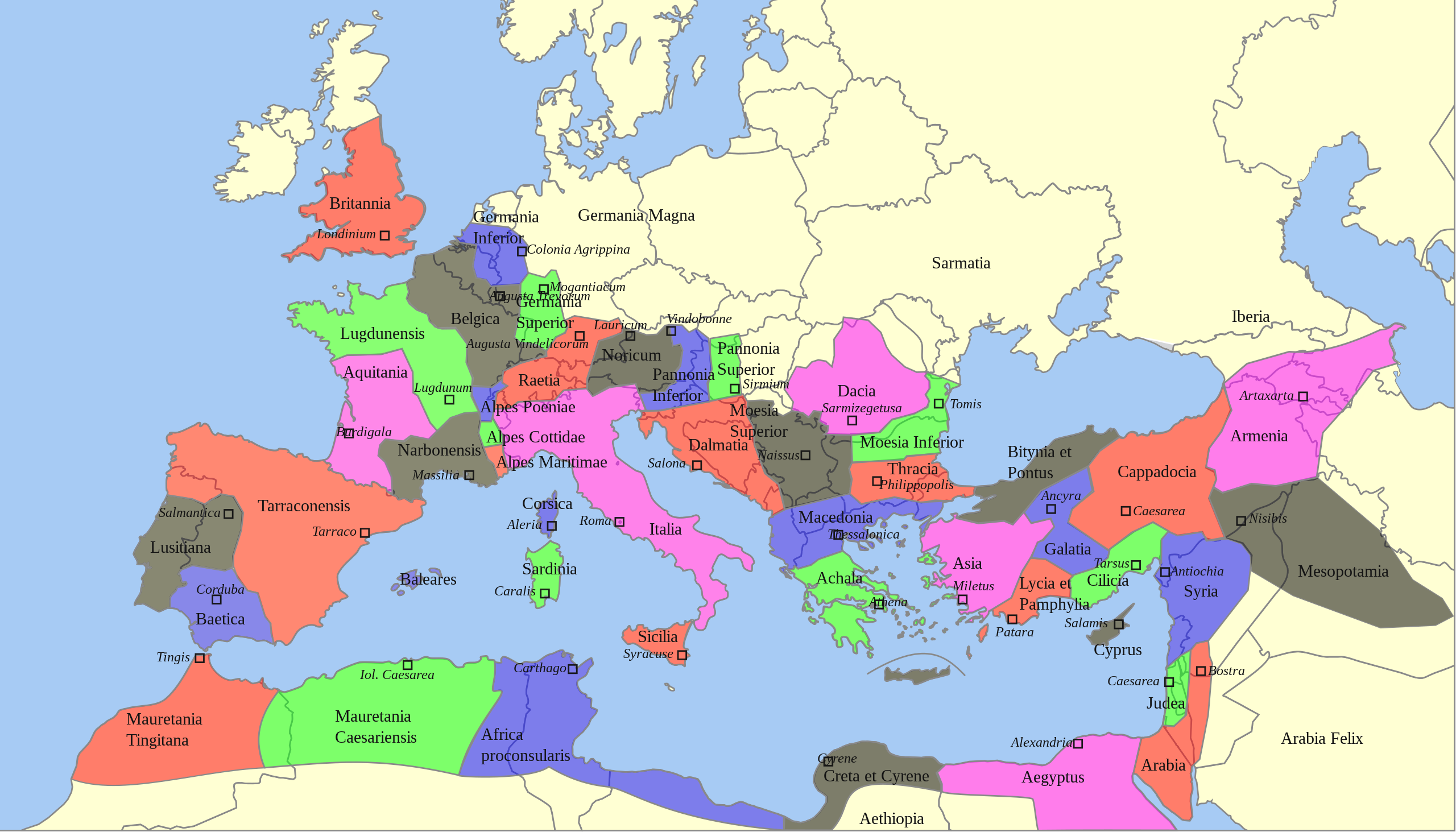
Deutsch: Territoriale Ausdehnung und provinziale Aufteilung des Römischen Reichs unter Trajan (117 n. Chr.) auf einer politischen Karte von 2013
English: Territorial extension and provincial division of the Roman Empire under Trajan (117 AD) on a political map of 2013 |
| Date | |
| Source |
This file was derived from: |
| Author |
|
| SVG development |
Licensing
Sebastian Wallroth, the copyright holder of this work, hereby publishes it under the following license:
| I, the copyright holder of this work, release this work into the
public domain. This applies worldwide. In some countries this may not be legally possible; if so: I grant anyone the right to use this work for any purpose, without any conditions, unless such conditions are required by law. |
Original upload log
This image is a derivative work of the following images:
-
Roemischeprovinzentrajan.png licensed with PD-Demis
- 2007-06-29T05:49:35Z ThomasPusch 1218x730 (314106 Bytes) Name of "Mauretania Caesariensis'' (one "s" was missing) corrected - Name von "Mauretania Caesariensis" berichtigt - nomo de "Mauretania Caesariensis'' korektita
- 2005-11-27T11:10:02Z FJ-de 1218x730 (339534 Bytes) Karte ist erstellt von mir - Vorlage Demis http://www.demis.nl/wms/mapclip.htm
-
Blank Map of Europe -w boundaries.svg licensed with Cc-by-sa-2.5,2.0,1.0, Cc-by-sa-3.0-migrated, GFDL
- 2008-06-19T01:33:53Z Roke 2045x1720 (724499 Bytes) more accurate version derived from [[:Image:Location European nation states.svg]] using same colours
- 2006-09-25T23:00:04Z Madman2001 0x0 (224972 Bytes) A blank map of Europe using Wikipedia standard colors in SVG format, based on [[:Image:BlankMap-Europe-v5.png]]. Note that the borders represent a second object "grouped" with the outline of Europe.
Uploaded with derivativeFX
File history
Click on a date/time to view the file as it appeared at that time.
| Date/Time | Thumbnail | Dimensions | User | Comment | |
|---|---|---|---|---|---|
| current | 06:59, 22 February 2022 |
| 1,732 × 990 (757 KB) | Chaddy | Reverted to version as of 08:05, 17 May 2013 (UTC) this map is heavily broken since September |
| 17:00, 24 September 2021 |
 | 1,732 × 990 (576 KB) | Sebastian Wallroth | invalid element removed // Editing SVG source code using c:User:Rillke/SVGedit.js | |
| 16:55, 24 September 2021 |
 | 1,732 × 990 (576 KB) | Sebastian Wallroth | justified // Editing SVG source code using c:User:Rillke/SVGedit.js | |
| 16:52, 24 September 2021 |
 | 1,732 × 990 (577 KB) | Sebastian Wallroth | edited // Editing SVG source code using c:User:Rillke/SVGedit.js | |
| 16:48, 24 September 2021 |
 | 1,732 × 990 (579 KB) | Sebastian Wallroth | code reviewed // Editing SVG source code using c:User:Rillke/SVGedit.js | |
| 08:05, 17 May 2013 |
 | 1,732 × 990 (757 KB) | Sebastian Wallroth | pure SVG | |
| 07:51, 17 May 2013 |
 | 1,732 × 990 (756 KB) | Sebastian Wallroth | cut out | |
| 07:49, 17 May 2013 |
 | 2,043 × 982 (679 KB) | Sebastian Wallroth | == {{int:filedesc}} == {{Information |Description={{de|Territoriale Ausdehnung und provinziale Aufteilung des Römischen Reichs unter Trajan (117 n. Chr.) auf einer politischen Karte von 2013}} {{en|Territorial extension and provincial division of the ... |
File usage
The following pages on the English Wikipedia use this file (pages on other projects are not listed):
Global file usage
The following other wikis use this file:
- Usage on es.wikibooks.org
- Usage on sk.wikipedia.org
Metadata
Size of this PNG preview of this SVG file:
800 × 457 pixels. Other resolutions:
320 × 183 pixels |
640 × 366 pixels |
1,024 × 585 pixels |
1,280 × 732 pixels |
2,560 × 1,463 pixels |
1,732 × 990 pixels.
Original file (SVG file, nominally 1,732 × 990 pixels, file size: 757 KB)
| This is a file from the
Wikimedia Commons. Information from its
description page there is shown below. Commons is a freely licensed media file repository. You can help. |
Summary
| Description |
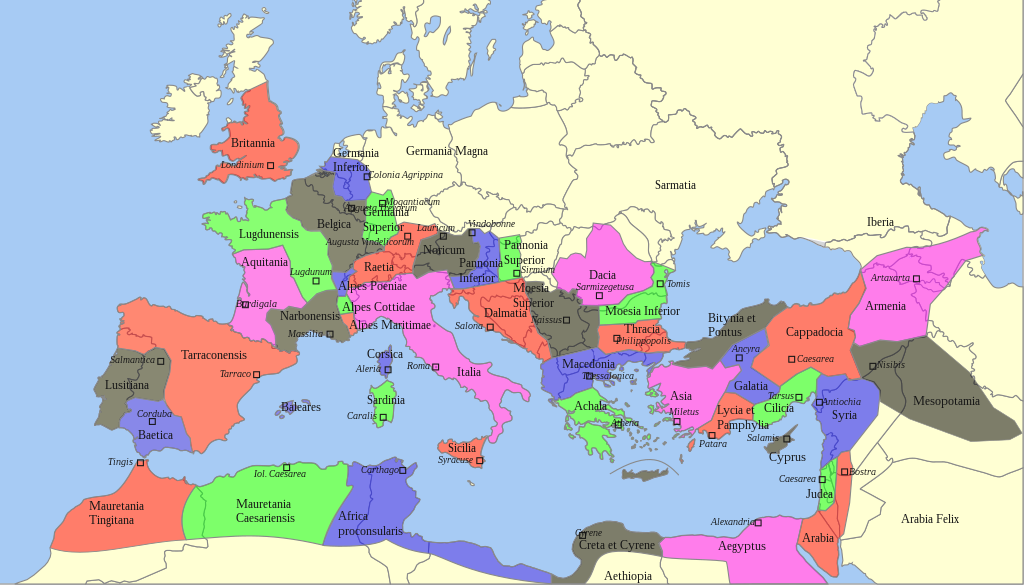
Deutsch: Territoriale Ausdehnung und provinziale Aufteilung des Römischen Reichs unter Trajan (117 n. Chr.) auf einer politischen Karte von 2013
English: Territorial extension and provincial division of the Roman Empire under Trajan (117 AD) on a political map of 2013 |
| Date | |
| Source |
This file was derived from: |
| Author |
|
| SVG development |
Licensing
Sebastian Wallroth, the copyright holder of this work, hereby publishes it under the following license:
| I, the copyright holder of this work, release this work into the
public domain. This applies worldwide. In some countries this may not be legally possible; if so: I grant anyone the right to use this work for any purpose, without any conditions, unless such conditions are required by law. |
Original upload log
This image is a derivative work of the following images:
-
Roemischeprovinzentrajan.png licensed with PD-Demis
- 2007-06-29T05:49:35Z ThomasPusch 1218x730 (314106 Bytes) Name of "Mauretania Caesariensis'' (one "s" was missing) corrected - Name von "Mauretania Caesariensis" berichtigt - nomo de "Mauretania Caesariensis'' korektita
- 2005-11-27T11:10:02Z FJ-de 1218x730 (339534 Bytes) Karte ist erstellt von mir - Vorlage Demis http://www.demis.nl/wms/mapclip.htm
-
Blank Map of Europe -w boundaries.svg licensed with Cc-by-sa-2.5,2.0,1.0, Cc-by-sa-3.0-migrated, GFDL
- 2008-06-19T01:33:53Z Roke 2045x1720 (724499 Bytes) more accurate version derived from [[:Image:Location European nation states.svg]] using same colours
- 2006-09-25T23:00:04Z Madman2001 0x0 (224972 Bytes) A blank map of Europe using Wikipedia standard colors in SVG format, based on [[:Image:BlankMap-Europe-v5.png]]. Note that the borders represent a second object "grouped" with the outline of Europe.
Uploaded with derivativeFX
File history
Click on a date/time to view the file as it appeared at that time.
| Date/Time | Thumbnail | Dimensions | User | Comment | |
|---|---|---|---|---|---|
| current | 06:59, 22 February 2022 |
| 1,732 × 990 (757 KB) | Chaddy | Reverted to version as of 08:05, 17 May 2013 (UTC) this map is heavily broken since September |
| 17:00, 24 September 2021 |
| 1,732 × 990 (576 KB) | Sebastian Wallroth | invalid element removed // Editing SVG source code using c:User:Rillke/SVGedit.js | |
| 16:55, 24 September 2021 |
| 1,732 × 990 (576 KB) | Sebastian Wallroth | justified // Editing SVG source code using c:User:Rillke/SVGedit.js | |
| 16:52, 24 September 2021 |
| 1,732 × 990 (577 KB) | Sebastian Wallroth | edited // Editing SVG source code using c:User:Rillke/SVGedit.js | |
| 16:48, 24 September 2021 |
| 1,732 × 990 (579 KB) | Sebastian Wallroth | code reviewed // Editing SVG source code using c:User:Rillke/SVGedit.js | |
| 08:05, 17 May 2013 |
| 1,732 × 990 (757 KB) | Sebastian Wallroth | pure SVG | |
| 07:51, 17 May 2013 |
| 1,732 × 990 (756 KB) | Sebastian Wallroth | cut out | |
| 07:49, 17 May 2013 |
| 2,043 × 982 (679 KB) | Sebastian Wallroth | == {{int:filedesc}} == {{Information |Description={{de|Territoriale Ausdehnung und provinziale Aufteilung des Römischen Reichs unter Trajan (117 n. Chr.) auf einer politischen Karte von 2013}} {{en|Territorial extension and provincial division of the ... |
File usage
The following pages on the English Wikipedia use this file (pages on other projects are not listed):
Global file usage
The following other wikis use this file:
- Usage on es.wikibooks.org
- Usage on sk.wikipedia.org