
Size of this preview:
504 × 600 pixels. Other resolutions:
202 × 240 pixels |
600 × 714 pixels.
Original file (600 × 714 pixels, file size: 400 KB, MIME type: image/png)
| This is a file from the
Wikimedia Commons. Information from its
description page there is shown below. Commons is a freely licensed media file repository. You can help. |
| Description |
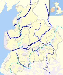
English: Rivers and canals in the ceremonial county of
Lancashire in England |
| Date | (UTC) |
| Source | |
| Author |
|
I, the copyright holder of this work, hereby publish it under the following license:
| I, the copyright holder of this work, release this work into the
public domain. This applies worldwide. In some countries this may not be legally possible; if so: I grant anyone the right to use this work for any purpose, without any conditions, unless such conditions are required by law. |
Original upload log
This image is a derivative work of the following images:
-
File:Lancashire_outline_map_with_UK.png licensed with PD-self
- 2008-06-25T12:11:31Z Jza84 600x714 (432721 Bytes) Reverted to version as of 13:59, 26 March 2008
- 2008-06-25T00:35:34Z Jza84 600x714 (459262 Bytes) Reverted to version as of 13:56, 26 March 2008 - testing darker boundaries
- 2008-03-26T13:59:34Z Jza84 600x714 (432721 Bytes) Reverted to version as of 20:12, 21 June 2007
- 2008-03-26T13:56:04Z Jza84 600x714 (459262 Bytes) Reverted to version as of 20:32, 19 June 2007
- 2007-06-21T20:12:25Z Jza84 600x714 (432721 Bytes) making some corrections
- 2007-06-19T20:32:57Z Jza84 600x714 (459262 Bytes) {{Information |Description= A map of [[Lancashire]], in [[North West England |Source=self-made |Date=19-06-2007 |Author= [[User:Jhamez84|Jhamez84]] }}
Uploaded with derivativeFX
File history
Click on a date/time to view the file as it appeared at that time.
| Date/Time | Thumbnail | Dimensions | User | Comment | |
|---|---|---|---|---|---|
| current | 15:44, 22 May 2010 |
| 600 × 714 (400 KB) | Dr Greg | Improved accuracy of river courses |
| 19:01, 21 May 2010 |
 | 600 × 714 (399 KB) | Dr Greg | {{Information |Description={{en|Rivers and canals in the ceremonial county of en:Lancashire in England}} |Source=* File:Lancashire_outline_map_with_UK.png |Date=2010-05-21 18:54 (UTC) |Author=* File:Lancashire_outline_map_with_UK.png: [[Us |
File usage
The following pages on the English Wikipedia use this file (pages on other projects are not listed):
Global file usage
The following other wikis use this file:
- Usage on arz.wikipedia.org
- Usage on de.wikipedia.org
- Usage on es.wikipedia.org
- Usage on lt.wikipedia.org
- Usage on www.wikidata.org
Size of this preview:
504 × 600 pixels. Other resolutions:
202 × 240 pixels |
600 × 714 pixels.
Original file (600 × 714 pixels, file size: 400 KB, MIME type: image/png)
| This is a file from the
Wikimedia Commons. Information from its
description page there is shown below. Commons is a freely licensed media file repository. You can help. |
| Description |
English: Rivers and canals in the ceremonial county of
Lancashire in England |
| Date | (UTC) |
| Source | |
| Author |
|
I, the copyright holder of this work, hereby publish it under the following license:
| I, the copyright holder of this work, release this work into the
public domain. This applies worldwide. In some countries this may not be legally possible; if so: I grant anyone the right to use this work for any purpose, without any conditions, unless such conditions are required by law. |
Original upload log
This image is a derivative work of the following images:
-
File:Lancashire_outline_map_with_UK.png licensed with PD-self
- 2008-06-25T12:11:31Z Jza84 600x714 (432721 Bytes) Reverted to version as of 13:59, 26 March 2008
- 2008-06-25T00:35:34Z Jza84 600x714 (459262 Bytes) Reverted to version as of 13:56, 26 March 2008 - testing darker boundaries
- 2008-03-26T13:59:34Z Jza84 600x714 (432721 Bytes) Reverted to version as of 20:12, 21 June 2007
- 2008-03-26T13:56:04Z Jza84 600x714 (459262 Bytes) Reverted to version as of 20:32, 19 June 2007
- 2007-06-21T20:12:25Z Jza84 600x714 (432721 Bytes) making some corrections
- 2007-06-19T20:32:57Z Jza84 600x714 (459262 Bytes) {{Information |Description= A map of [[Lancashire]], in [[North West England |Source=self-made |Date=19-06-2007 |Author= [[User:Jhamez84|Jhamez84]] }}
Uploaded with derivativeFX
File history
Click on a date/time to view the file as it appeared at that time.
| Date/Time | Thumbnail | Dimensions | User | Comment | |
|---|---|---|---|---|---|
| current | 15:44, 22 May 2010 |
| 600 × 714 (400 KB) | Dr Greg | Improved accuracy of river courses |
| 19:01, 21 May 2010 |
| 600 × 714 (399 KB) | Dr Greg | {{Information |Description={{en|Rivers and canals in the ceremonial county of en:Lancashire in England}} |Source=* File:Lancashire_outline_map_with_UK.png |Date=2010-05-21 18:54 (UTC) |Author=* File:Lancashire_outline_map_with_UK.png: [[Us |
File usage
The following pages on the English Wikipedia use this file (pages on other projects are not listed):
Global file usage
The following other wikis use this file:
- Usage on arz.wikipedia.org
- Usage on de.wikipedia.org
- Usage on es.wikipedia.org
- Usage on lt.wikipedia.org
- Usage on www.wikidata.org