Photos • Location


No higher resolution available.
River_Camlad_-_geograph.org.uk_-_826700.jpg (640 × 480 pixels, file size: 96 KB, MIME type: image/jpeg)
| This is a file from the
Wikimedia Commons. Information from its
description page there is shown below. Commons is a freely licensed media file repository. You can help. |
Summary
| Description |
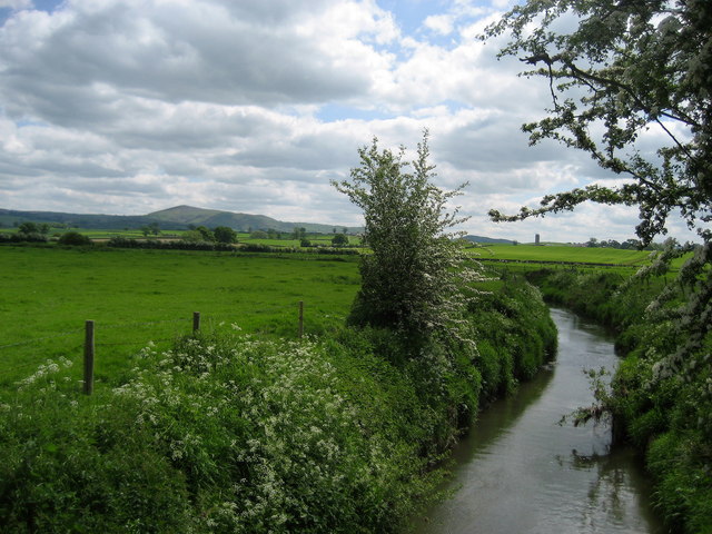
English: River Camlad As seen from the footbridge that carries the Offa's Dyke National Trail over the river. According to my guide book, this channel is unique, as the only major watercourse that flows into Wales from England - rather than the other way round. |
| Date | |
| Source | From geograph.org.uk |
| Author | Chris Heaton |
| Attribution ( required by the license) | Chris Heaton / River Camlad / |
| Camera location | | View this and other nearby images on: OpenStreetMap |
|
|---|
_heading:135.00&language=en)
| Object location | | View this and other nearby images on: OpenStreetMap |
|
|---|
_heading:135.00&language=en)
Licensing

|
This image was taken from the
Geograph project collection. See
this photograph's page on the Geograph website for the photographer's contact details. The copyright on this image is owned by Chris Heaton and is licensed for reuse under the
Creative Commons Attribution-ShareAlike 2.0 license.
|
This file is licensed under the
Creative Commons
Attribution-Share Alike 2.0 Generic license.
Attribution: Chris Heaton
- You are free:
- to share – to copy, distribute and transmit the work
- to remix – to adapt the work
- Under the following conditions:
- attribution – You must give appropriate credit, provide a link to the license, and indicate if changes were made. You may do so in any reasonable manner, but not in any way that suggests the licensor endorses you or your use.
- share alike – If you remix, transform, or build upon the material, you must distribute your contributions under the same or compatible license as the original.
File history
Click on a date/time to view the file as it appeared at that time.
| Date/Time | Thumbnail | Dimensions | User | Comment | |
|---|---|---|---|---|---|
| current | 16:39, 20 February 2011 |
| 640 × 480 (96 KB) | GeographBot | == {{int:filedesc}} == {{Information |description={{en|1=River Camlad As seen from the footbridge that carries the Offa's Dyke National Trail over the river. According to my guide book, this channel is unique, as the only major watercourse that flows int |
File usage
The following pages on the English Wikipedia use this file (pages on other projects are not listed):
Global file usage
The following other wikis use this file:
- Usage on cy.wikipedia.org
- Usage on gl.wikipedia.org
- Usage on www.wikidata.org
Metadata
No higher resolution available.
River_Camlad_-_geograph.org.uk_-_826700.jpg (640 × 480 pixels, file size: 96 KB, MIME type: image/jpeg)
| This is a file from the
Wikimedia Commons. Information from its
description page there is shown below. Commons is a freely licensed media file repository. You can help. |
Summary
| Description |
English: River Camlad As seen from the footbridge that carries the Offa's Dyke National Trail over the river. According to my guide book, this channel is unique, as the only major watercourse that flows into Wales from England - rather than the other way round. |
| Date | |
| Source | From geograph.org.uk |
| Author | Chris Heaton |
| Attribution ( required by the license) | Chris Heaton / River Camlad / |
| Camera location | | View this and other nearby images on: OpenStreetMap |
|
|---|
| Object location | | View this and other nearby images on: OpenStreetMap |
|
|---|
Licensing
|
|
This image was taken from the
Geograph project collection. See
this photograph's page on the Geograph website for the photographer's contact details. The copyright on this image is owned by Chris Heaton and is licensed for reuse under the
Creative Commons Attribution-ShareAlike 2.0 license.
|
This file is licensed under the
Creative Commons
Attribution-Share Alike 2.0 Generic license.
Attribution: Chris Heaton
- You are free:
- to share – to copy, distribute and transmit the work
- to remix – to adapt the work
- Under the following conditions:
- attribution – You must give appropriate credit, provide a link to the license, and indicate if changes were made. You may do so in any reasonable manner, but not in any way that suggests the licensor endorses you or your use.
- share alike – If you remix, transform, or build upon the material, you must distribute your contributions under the same or compatible license as the original.
File history
Click on a date/time to view the file as it appeared at that time.
| Date/Time | Thumbnail | Dimensions | User | Comment | |
|---|---|---|---|---|---|
| current | 16:39, 20 February 2011 |
| 640 × 480 (96 KB) | GeographBot | == {{int:filedesc}} == {{Information |description={{en|1=River Camlad As seen from the footbridge that carries the Offa's Dyke National Trail over the river. According to my guide book, this channel is unique, as the only major watercourse that flows int |
File usage
The following pages on the English Wikipedia use this file (pages on other projects are not listed):
Global file usage
The following other wikis use this file:
- Usage on cy.wikipedia.org
- Usage on gl.wikipedia.org
- Usage on www.wikidata.org