
Size of this preview:
800 × 552 pixels. Other resolutions:
320 × 221 pixels |
640 × 442 pixels |
1,024 × 707 pixels |
1,280 × 883 pixels |
2,560 × 1,767 pixels |
4,053 × 2,797 pixels.
Original file (4,053 × 2,797 pixels, file size: 7.74 MB, MIME type: image/png)
| This is a file from the
Wikimedia Commons. Information from its
description page there is shown below. Commons is a freely licensed media file repository. You can help. |
Summary
| Description |
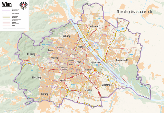
Deutsch: Reliefkarte Wien
Topographischer Hintergrund: NASA Shuttle Radar Topography Mission (public domain). SRTM3 v.2. Rest: Openstreetmap |
||||||||
| Date | |||||||||
| Source | Own work | ||||||||
| Author | Tschubby | ||||||||
| Permission ( Reusing this file) |
I, the copyright holder of this work, hereby publish it under the following licenses:
This file is licensed under the
Creative Commons Attribution-Share Alike
2.5 Generic,
2.0 Generic and
1.0 Generic license.
You may select the license of your choice. |

File history
Click on a date/time to view the file as it appeared at that time.
| Date/Time | Thumbnail | Dimensions | User | Comment | |
|---|---|---|---|---|---|
| current | 09:27, 13 May 2021 |
| 4,053 × 2,797 (7.74 MB) | Tschubby | {{Information |Description= |Source= |Date= |Author= |Permission= |other_versions= }} |
| 15:25, 7 May 2021 |
 | 4,053 × 2,797 (7.75 MB) | Tschubby | == {{int:filedesc}} == {{Information |Description= {{de| Reliefkarte Wien}} Topographischer Hintergrund: [http://www2.jpl.nasa.gov/srtm NASA Shuttle Radar Topography Mission] (public domain). SRTM3 v.2. Rest: [http://www.openstreetmap.org Openstreetmap] |Source={{own}} |Date= 2021-05-07 |Author= Tschubby |Permission= {{self|GFDL|Cc-by-sa-3.0-migrated|Cc-by-sa-2.5,2.0,1.0}} |other_versions= }} Wien |
File usage
The following pages on the English Wikipedia use this file (pages on other projects are not listed):
Global file usage
The following other wikis use this file:
- Usage on az.wikipedia.org
- Usage on de.wikipedia.org
- Usage on lld.wikipedia.org
Metadata
Size of this preview:
800 × 552 pixels. Other resolutions:
320 × 221 pixels |
640 × 442 pixels |
1,024 × 707 pixels |
1,280 × 883 pixels |
2,560 × 1,767 pixels |
4,053 × 2,797 pixels.
Original file (4,053 × 2,797 pixels, file size: 7.74 MB, MIME type: image/png)
| This is a file from the
Wikimedia Commons. Information from its
description page there is shown below. Commons is a freely licensed media file repository. You can help. |
Summary
| Description |
Deutsch: Reliefkarte Wien
Topographischer Hintergrund: NASA Shuttle Radar Topography Mission (public domain). SRTM3 v.2. Rest: Openstreetmap |
||||||||
| Date | |||||||||
| Source | Own work | ||||||||
| Author | Tschubby | ||||||||
| Permission ( Reusing this file) |
I, the copyright holder of this work, hereby publish it under the following licenses:
This file is licensed under the
Creative Commons Attribution-Share Alike
2.5 Generic,
2.0 Generic and
1.0 Generic license.
You may select the license of your choice. |
File history
Click on a date/time to view the file as it appeared at that time.
| Date/Time | Thumbnail | Dimensions | User | Comment | |
|---|---|---|---|---|---|
| current | 09:27, 13 May 2021 |
| 4,053 × 2,797 (7.74 MB) | Tschubby | {{Information |Description= |Source= |Date= |Author= |Permission= |other_versions= }} |
| 15:25, 7 May 2021 |
| 4,053 × 2,797 (7.75 MB) | Tschubby | == {{int:filedesc}} == {{Information |Description= {{de| Reliefkarte Wien}} Topographischer Hintergrund: [http://www2.jpl.nasa.gov/srtm NASA Shuttle Radar Topography Mission] (public domain). SRTM3 v.2. Rest: [http://www.openstreetmap.org Openstreetmap] |Source={{own}} |Date= 2021-05-07 |Author= Tschubby |Permission= {{self|GFDL|Cc-by-sa-3.0-migrated|Cc-by-sa-2.5,2.0,1.0}} |other_versions= }} Wien |
File usage
The following pages on the English Wikipedia use this file (pages on other projects are not listed):
Global file usage
The following other wikis use this file:
- Usage on az.wikipedia.org
- Usage on de.wikipedia.org
- Usage on lld.wikipedia.org