Size of this preview:
765 × 600 pixels. Other resolutions:
306 × 240 pixels |
612 × 480 pixels |
980 × 768 pixels |
1,280 × 1,004 pixels |
2,560 × 2,007 pixels |
3,000 × 2,352 pixels.
Original file (3,000 × 2,352 pixels, file size: 1.36 MB, MIME type: image/png)
| This is a file from the
Wikimedia Commons. Information from its
description page there is shown below. Commons is a freely licensed media file repository. You can help. |
Summary
| Description |
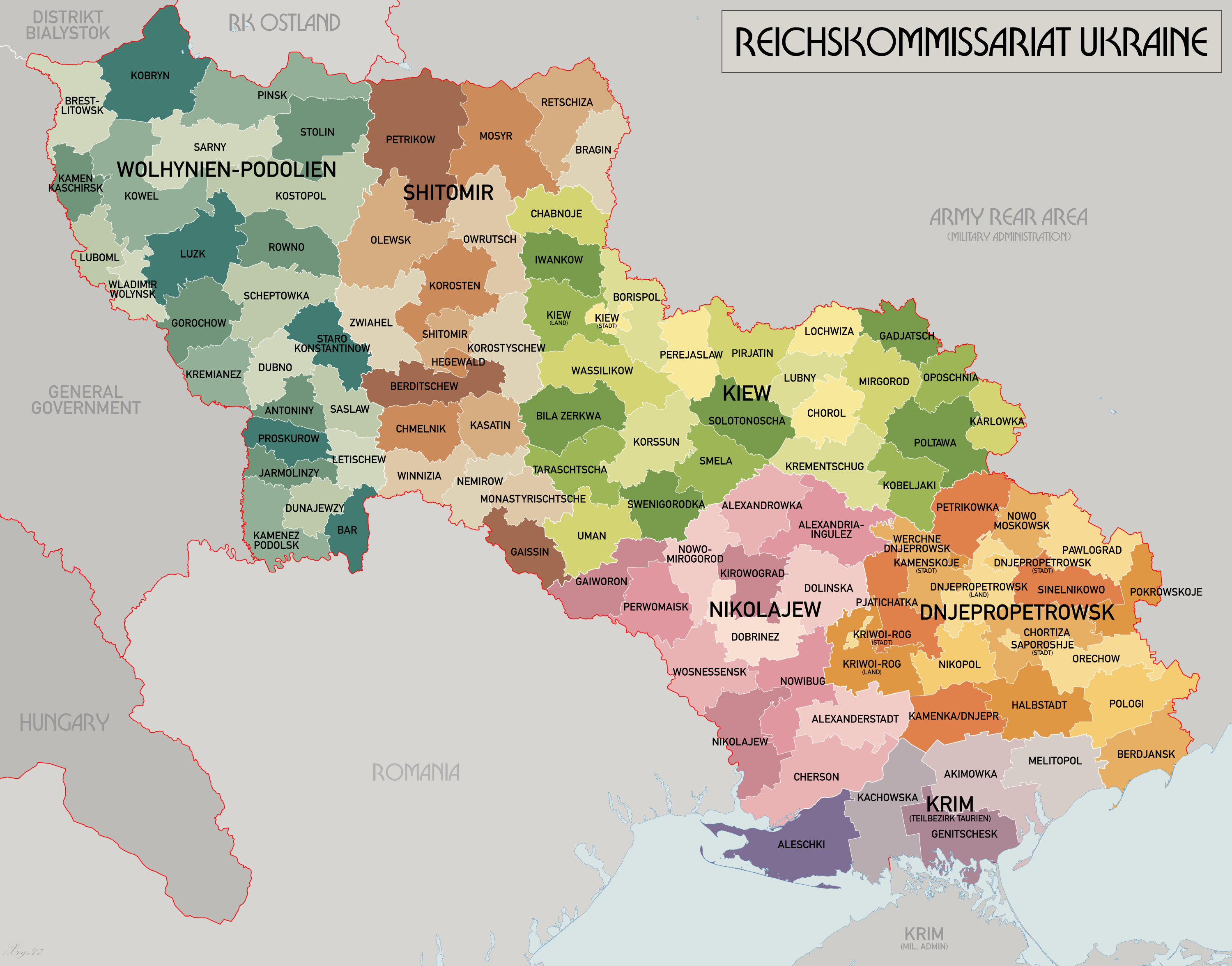
English: An administrative map of the Reichskommissariat Ukraine. Shows the boundaries of the Generalbezirke and Kreisgebiete as of September 1943. Source map data:
|
| Date | |
| Source | Own work |
| Author | XrysD |
| Other versions | Derivative works of this file: HegewaldColonyMap.png |
Licensing
I, the copyright holder of this work, hereby publish it under the following license:

|
Permission is granted to copy, distribute and/or modify this document under the terms of the GNU Free Documentation License, Version 1.2 or any later version published by the Free Software Foundation; with no Invariant Sections, no Front-Cover Texts, and no Back-Cover Texts. A copy of the license is included in the section entitled GNU Free Documentation License. |
| This file is licensed under the Creative Commons Attribution-Share Alike 3.0 Unported license. | ||
| ||
| This licensing tag was added to this file as part of the GFDL licensing update. |
File history
Click on a date/time to view the file as it appeared at that time.
| Date/Time | Thumbnail | Dimensions | User | Comment | |
|---|---|---|---|---|---|
| current | 09:25, 21 May 2017 |
| 3,000 × 2,352 (1.36 MB) | XrysD | Reduced size and fixed edge issue. |
| 09:21, 21 May 2017 |
 | 4,000 × 3,197 (1.95 MB) | XrysD | Completely new version. Source map data: [Verwaltungskarten Gebietes Ukraine 1:500k, US Library of Congress], [Karte des Deutschen Reiches (Grossblatter) 1:100k, Mapa Administracyjna Rzeczypospolitej Polska 1:300k, Karte von Mitteleuropa 1:300k, MapyWig] | |
| 16:39, 8 December 2015 |
 | 1,803 × 1,060 (714 KB) | Artemco | • occupied territory under military administration, not directly Soviet Union • capital letters as Romania had • C → G | |
| 20:59, 16 May 2012 |
 | 1,803 × 1,060 (708 KB) | XrysD | Added legend. Changed surrounding state names to common English versions. Changed colour set to Bartholomew version. | |
| 13:01, 22 July 2008 |
 | 1,803 × 1,060 (205 KB) | XrysD | {{Information |Description={{en|1=An administrative map of the Reichskommissariat Ukraine. Shows the boundaries of the Generalbezirke and Kreisgebiete as of September 1943.}} |Source=Own work by uploader |Author= XrysD |Date=2008 |Permission |
File usage
The following pages on the English Wikipedia use this file (pages on other projects are not listed):
Global file usage
The following other wikis use this file:
- Usage on ar.wikipedia.org
- Usage on az.wikipedia.org
- Usage on be-tarask.wikipedia.org
- Usage on be.wikipedia.org
- Usage on bs.wikipedia.org
- Usage on ca.wikipedia.org
- Usage on cs.wikipedia.org
- Usage on da.wikipedia.org
- Usage on es.wikipedia.org
- Usage on fa.wikipedia.org
- Usage on fr.wikipedia.org
- Usage on he.wikipedia.org
- Usage on hr.wikipedia.org
- Usage on id.wikipedia.org
- Usage on it.wikipedia.org
- Usage on ja.wikipedia.org
- Usage on lt.wikipedia.org
- Usage on ms.wikipedia.org
- Usage on nl.wikipedia.org
- Usage on pl.wikipedia.org
- Usage on pt.wikipedia.org
- Usage on ro.wikipedia.org
- Usage on ru.wikipedia.org
- Usage on sh.wikipedia.org
- Usage on sr.wikipedia.org
- Usage on sv.wikipedia.org
- Usage on th.wikipedia.org
- Usage on uk.wikipedia.org
- Історія України
- Кременчуцький район (1939—2020)
- Райхскомісаріат Україна
- Країни Осі
- Генеральна округа Дніпропетровськ
- Адміністративно-територіальний устрій Полтавської області
- Генеральна округа Миколаїв
- Користувач:Alex Blokha/Дні згадані в Вікіпедії/Україна/15 жовтня
- Користувач:Alex Blokha/Дні згадані в Вікіпедії/Україна/28 жовтня
View more global usage of this file.
Metadata
Size of this preview:
765 × 600 pixels. Other resolutions:
306 × 240 pixels |
612 × 480 pixels |
980 × 768 pixels |
1,280 × 1,004 pixels |
2,560 × 2,007 pixels |
3,000 × 2,352 pixels.
Original file (3,000 × 2,352 pixels, file size: 1.36 MB, MIME type: image/png)
| This is a file from the
Wikimedia Commons. Information from its
description page there is shown below. Commons is a freely licensed media file repository. You can help. |
Summary
| Description |
English: An administrative map of the Reichskommissariat Ukraine. Shows the boundaries of the Generalbezirke and Kreisgebiete as of September 1943. Source map data:
|
| Date | |
| Source | Own work |
| Author | XrysD |
| Other versions | Derivative works of this file: HegewaldColonyMap.png |
Licensing
I, the copyright holder of this work, hereby publish it under the following license:
|
|
Permission is granted to copy, distribute and/or modify this document under the terms of the GNU Free Documentation License, Version 1.2 or any later version published by the Free Software Foundation; with no Invariant Sections, no Front-Cover Texts, and no Back-Cover Texts. A copy of the license is included in the section entitled GNU Free Documentation License. |
| This file is licensed under the Creative Commons Attribution-Share Alike 3.0 Unported license. | ||
| ||
| This licensing tag was added to this file as part of the GFDL licensing update. |
File history
Click on a date/time to view the file as it appeared at that time.
| Date/Time | Thumbnail | Dimensions | User | Comment | |
|---|---|---|---|---|---|
| current | 09:25, 21 May 2017 |
| 3,000 × 2,352 (1.36 MB) | XrysD | Reduced size and fixed edge issue. |
| 09:21, 21 May 2017 |
| 4,000 × 3,197 (1.95 MB) | XrysD | Completely new version. Source map data: [Verwaltungskarten Gebietes Ukraine 1:500k, US Library of Congress], [Karte des Deutschen Reiches (Grossblatter) 1:100k, Mapa Administracyjna Rzeczypospolitej Polska 1:300k, Karte von Mitteleuropa 1:300k, MapyWig] | |
| 16:39, 8 December 2015 |
| 1,803 × 1,060 (714 KB) | Artemco | • occupied territory under military administration, not directly Soviet Union • capital letters as Romania had • C → G | |
| 20:59, 16 May 2012 |
| 1,803 × 1,060 (708 KB) | XrysD | Added legend. Changed surrounding state names to common English versions. Changed colour set to Bartholomew version. | |
| 13:01, 22 July 2008 |
| 1,803 × 1,060 (205 KB) | XrysD | {{Information |Description={{en|1=An administrative map of the Reichskommissariat Ukraine. Shows the boundaries of the Generalbezirke and Kreisgebiete as of September 1943.}} |Source=Own work by uploader |Author= XrysD |Date=2008 |Permission |
File usage
The following pages on the English Wikipedia use this file (pages on other projects are not listed):
Global file usage
The following other wikis use this file:
- Usage on ar.wikipedia.org
- Usage on az.wikipedia.org
- Usage on be-tarask.wikipedia.org
- Usage on be.wikipedia.org
- Usage on bs.wikipedia.org
- Usage on ca.wikipedia.org
- Usage on cs.wikipedia.org
- Usage on da.wikipedia.org
- Usage on es.wikipedia.org
- Usage on fa.wikipedia.org
- Usage on fr.wikipedia.org
- Usage on he.wikipedia.org
- Usage on hr.wikipedia.org
- Usage on id.wikipedia.org
- Usage on it.wikipedia.org
- Usage on ja.wikipedia.org
- Usage on lt.wikipedia.org
- Usage on ms.wikipedia.org
- Usage on nl.wikipedia.org
- Usage on pl.wikipedia.org
- Usage on pt.wikipedia.org
- Usage on ro.wikipedia.org
- Usage on ru.wikipedia.org
- Usage on sh.wikipedia.org
- Usage on sr.wikipedia.org
- Usage on sv.wikipedia.org
- Usage on th.wikipedia.org
- Usage on uk.wikipedia.org
- Історія України
- Кременчуцький район (1939—2020)
- Райхскомісаріат Україна
- Країни Осі
- Генеральна округа Дніпропетровськ
- Адміністративно-територіальний устрій Полтавської області
- Генеральна округа Миколаїв
- Користувач:Alex Blokha/Дні згадані в Вікіпедії/Україна/15 жовтня
- Користувач:Alex Blokha/Дні згадані в Вікіпедії/Україна/28 жовтня
View more global usage of this file.