Photos • Location


No higher resolution available.
RapideCrocheDamUSACE.jpg (512 × 346 pixels, file size: 51 KB, MIME type: image/jpeg)
| This is a file from the
Wikimedia Commons. Information from its
description page there is shown below. Commons is a freely licensed media file repository. You can help. |
|
This is an image of a place or building that is listed on the
National Register of Historic Places in the
United States of America. Its reference number is
93001326. |
| Description |
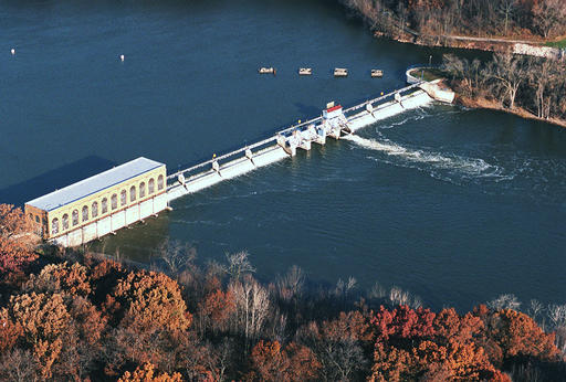
English: The
w:Rapide Croche Lock and Dam Historic District on the
w:Fox River (Wisconsin)west of
w:Wrightstown, Wisconsin on the Outagamie / Brown County line. |
|||
| Date | Unknown date | |||
| Source | http://www.lre.usace.army.mil/Photos/index.cfm?id=6412&pge_id=1797 | |||
| Author | Unknown author | |||
| Permission ( Reusing this file) |
|
| Object location |
| View this and other nearby images on: OpenStreetMap |
|
|---|
File history
Click on a date/time to view the file as it appeared at that time.
| Date/Time | Thumbnail | Dimensions | User | Comment | |
|---|---|---|---|---|---|
| current | 03:39, 25 March 2010 |
| 512 × 346 (51 KB) | Royalbroil | {{Information |Description={{en|1=The w:Rapide Croche Lock and Dam Historic District on the w:Fox River (Wisconsin)west of w:Wrightstown, Wisconsin on the Outagamie / Brown County line.}} |Source=http://www.lre.usace.army.mil/Photos/index.cfm? |
File usage
The following pages on the English Wikipedia use this file (pages on other projects are not listed):
Global file usage
The following other wikis use this file:
- Usage on de.wikipedia.org
Metadata
No higher resolution available.
RapideCrocheDamUSACE.jpg (512 × 346 pixels, file size: 51 KB, MIME type: image/jpeg)
| This is a file from the
Wikimedia Commons. Information from its
description page there is shown below. Commons is a freely licensed media file repository. You can help. |
|
This is an image of a place or building that is listed on the
National Register of Historic Places in the
United States of America. Its reference number is
93001326. |
| Description |
English: The
w:Rapide Croche Lock and Dam Historic District on the
w:Fox River (Wisconsin)west of
w:Wrightstown, Wisconsin on the Outagamie / Brown County line. |
|||
| Date | Unknown date | |||
| Source | http://www.lre.usace.army.mil/Photos/index.cfm?id=6412&pge_id=1797 | |||
| Author | Unknown author | |||
| Permission ( Reusing this file) |
|
| Object location |
| View this and other nearby images on: OpenStreetMap |
|
|---|
File history
Click on a date/time to view the file as it appeared at that time.
| Date/Time | Thumbnail | Dimensions | User | Comment | |
|---|---|---|---|---|---|
| current | 03:39, 25 March 2010 |
| 512 × 346 (51 KB) | Royalbroil | {{Information |Description={{en|1=The w:Rapide Croche Lock and Dam Historic District on the w:Fox River (Wisconsin)west of w:Wrightstown, Wisconsin on the Outagamie / Brown County line.}} |Source=http://www.lre.usace.army.mil/Photos/index.cfm? |
File usage
The following pages on the English Wikipedia use this file (pages on other projects are not listed):
Global file usage
The following other wikis use this file:
- Usage on de.wikipedia.org