Queen-Pyramid-G-III-b.jpg (411 × 242 pixels, file size: 27 KB, MIME type: image/jpeg)
| This is a file from the
Wikimedia Commons. Information from its
description page there is shown below. Commons is a freely licensed media file repository. You can help. |
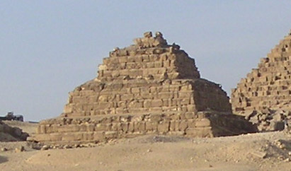
Queen Pyramid GIIIb of the Menkaure complex
Excerpt from Image:Gizeh Mykerinos 02.JPG
Summary
Vue de la face sud de la pyramide de Mykérinos à Gizeh avec ses trois pyramides de reines - IVe dynastie égyptienne
| Camera location | | View this and other nearby images on: OpenStreetMap |
|
|---|
Licensing
| I, the copyright holder of this work, release this work into the
public domain. This applies worldwide. In some countries this may not be legally possible; if so: I grant anyone the right to use this work for any purpose, without any conditions, unless such conditions are required by law. |
Source
File history
Click on a date/time to view the file as it appeared at that time.
| Date/Time | Thumbnail | Dimensions | User | Comment | |
|---|---|---|---|---|---|
| current | 12:53, 5 March 2008 |
| 411 × 242 (27 KB) | GDK | Queen Pyramid GIIIb of the Menkaure complex Excerpt from Image:Gizeh Mykerinos 02.JPG == Description == Vue de la face sud de la pyramide de Mykérinos à Gizeh avec ses trois pyramides de reines - IVe dynastie égyptienne {{Location|29|58|13.0|N|3 |
File usage
Global file usage
The following other wikis use this file:
- Usage on ar.wikipedia.org
- Usage on ba.wikipedia.org
- Usage on ca.wikipedia.org
- Usage on de.wikipedia.org
- Usage on el.wikipedia.org
- Usage on fa.wikipedia.org
- Usage on fr.wikipedia.org
- Usage on hu.wikipedia.org
- Usage on hy.wikipedia.org
- Usage on it.wikipedia.org
- Usage on ru.wikipedia.org
- Usage on uk.wikipedia.org
Queen-Pyramid-G-III-b.jpg (411 × 242 pixels, file size: 27 KB, MIME type: image/jpeg)
| This is a file from the
Wikimedia Commons. Information from its
description page there is shown below. Commons is a freely licensed media file repository. You can help. |
Queen Pyramid GIIIb of the Menkaure complex
Excerpt from Image:Gizeh Mykerinos 02.JPG
Summary
Vue de la face sud de la pyramide de Mykérinos à Gizeh avec ses trois pyramides de reines - IVe dynastie égyptienne
| Camera location | | View this and other nearby images on: OpenStreetMap |
|
|---|
Licensing
| I, the copyright holder of this work, release this work into the
public domain. This applies worldwide. In some countries this may not be legally possible; if so: I grant anyone the right to use this work for any purpose, without any conditions, unless such conditions are required by law. |
Source
File history
Click on a date/time to view the file as it appeared at that time.
| Date/Time | Thumbnail | Dimensions | User | Comment | |
|---|---|---|---|---|---|
| current | 12:53, 5 March 2008 |
| 411 × 242 (27 KB) | GDK | Queen Pyramid GIIIb of the Menkaure complex Excerpt from Image:Gizeh Mykerinos 02.JPG == Description == Vue de la face sud de la pyramide de Mykérinos à Gizeh avec ses trois pyramides de reines - IVe dynastie égyptienne {{Location|29|58|13.0|N|3 |
File usage
Global file usage
The following other wikis use this file:
- Usage on ar.wikipedia.org
- Usage on ba.wikipedia.org
- Usage on ca.wikipedia.org
- Usage on de.wikipedia.org
- Usage on el.wikipedia.org
- Usage on fa.wikipedia.org
- Usage on fr.wikipedia.org
- Usage on hu.wikipedia.org
- Usage on hy.wikipedia.org
- Usage on it.wikipedia.org
- Usage on ru.wikipedia.org
- Usage on uk.wikipedia.org