
Size of this preview:
800 × 574 pixels. Other resolutions:
320 × 230 pixels |
640 × 459 pixels |
1,024 × 735 pixels |
1,280 × 919 pixels |
1,592 × 1,143 pixels.
Original file (1,592 × 1,143 pixels, file size: 3.29 MB, MIME type: image/png)
| This is a file from the
Wikimedia Commons. Information from its
description page there is shown below. Commons is a freely licensed media file repository. You can help. |
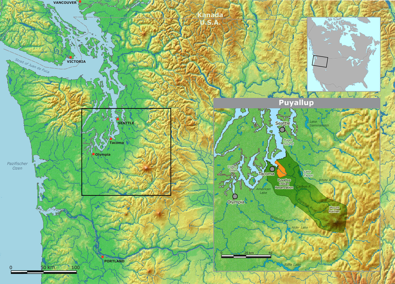
| Description | Map of traditional Puyallup tribal territory. | ||||
| Date | |||||
| Source | Own work by Nikater, submitted to the public domain. Background map courtesy of Demis, www.demis.nl | ||||
| Author | User:Nikater | ||||
| Permission ( Reusing this file) |
|
File history
Click on a date/time to view the file as it appeared at that time.
| Date/Time | Thumbnail | Dimensions | User | Comment | |
|---|---|---|---|---|---|
| current | 08:23, 2 May 2011 |
| 1,592 × 1,143 (3.29 MB) | Nikater | Ausschnitt der kleinen Karte eingefügt |
| 08:14, 2 May 2011 |
 | 1,592 × 1,143 (3.29 MB) | Nikater | Karte überarbeitet | |
| 08:05, 2 May 2011 |
 | 1,497 × 1,058 (2.87 MB) | Nikater | Karte überarbeitet | |
| 10:10, 12 December 2007 |
 | 1,497 × 1,058 (2.87 MB) | Nikater | {{Information |Description=Map of traditional Puyallup tribal territory. |Source=Own work by Nikater, submitted to the public domain. Background map courtesy of Demis, www.demis.nl |Date=12 December 2007 |Author= User:Nikater |Permission={{PD-Demis}} } |
File usage
The following pages on the English Wikipedia use this file (pages on other projects are not listed):
Global file usage
The following other wikis use this file:
- Usage on ar.wikipedia.org
- Usage on arz.wikipedia.org
- Usage on de.wikipedia.org
- Usage on fa.wikipedia.org
- Usage on hr.wikipedia.org
- Usage on hu.wikipedia.org
- Usage on id.wikipedia.org
- Usage on ja.wikipedia.org
- Usage on www.wikidata.org
Size of this preview:
800 × 574 pixels. Other resolutions:
320 × 230 pixels |
640 × 459 pixels |
1,024 × 735 pixels |
1,280 × 919 pixels |
1,592 × 1,143 pixels.
Original file (1,592 × 1,143 pixels, file size: 3.29 MB, MIME type: image/png)
| This is a file from the
Wikimedia Commons. Information from its
description page there is shown below. Commons is a freely licensed media file repository. You can help. |
| Description | Map of traditional Puyallup tribal territory. | ||||
| Date | |||||
| Source | Own work by Nikater, submitted to the public domain. Background map courtesy of Demis, www.demis.nl | ||||
| Author | User:Nikater | ||||
| Permission ( Reusing this file) |
|
File history
Click on a date/time to view the file as it appeared at that time.
| Date/Time | Thumbnail | Dimensions | User | Comment | |
|---|---|---|---|---|---|
| current | 08:23, 2 May 2011 |
| 1,592 × 1,143 (3.29 MB) | Nikater | Ausschnitt der kleinen Karte eingefügt |
| 08:14, 2 May 2011 |
| 1,592 × 1,143 (3.29 MB) | Nikater | Karte überarbeitet | |
| 08:05, 2 May 2011 |
| 1,497 × 1,058 (2.87 MB) | Nikater | Karte überarbeitet | |
| 10:10, 12 December 2007 |
| 1,497 × 1,058 (2.87 MB) | Nikater | {{Information |Description=Map of traditional Puyallup tribal territory. |Source=Own work by Nikater, submitted to the public domain. Background map courtesy of Demis, www.demis.nl |Date=12 December 2007 |Author= User:Nikater |Permission={{PD-Demis}} } |
File usage
The following pages on the English Wikipedia use this file (pages on other projects are not listed):
Global file usage
The following other wikis use this file:
- Usage on ar.wikipedia.org
- Usage on arz.wikipedia.org
- Usage on de.wikipedia.org
- Usage on fa.wikipedia.org
- Usage on hr.wikipedia.org
- Usage on hu.wikipedia.org
- Usage on id.wikipedia.org
- Usage on ja.wikipedia.org
- Usage on www.wikidata.org