No higher resolution available.
Puntland_oil.png (570 × 599 pixels, file size: 42 KB, MIME type: image/png)
| This is a file from the
Wikimedia Commons. Information from its
description page there is shown below. Commons is a freely licensed media file repository. You can help. |
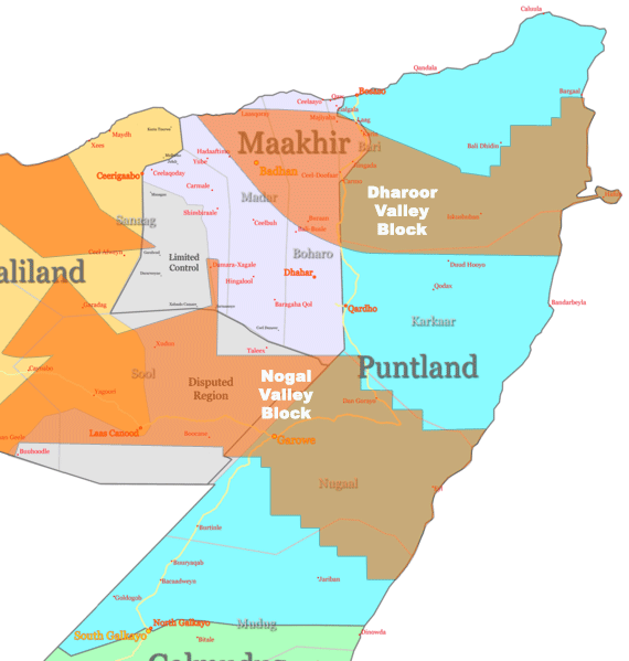
Khaatumo state of somalia Region sool lascanod not disputed area,and not exist clashes between two administration
Summary
| Description | Range Resources/African oil concessions superimposed over political map of these regions |
| Date | |
| Source | Own work |
| Author | Ingoman |
Licensing
| I, the copyright holder of this work, release this work into the
public domain. This applies worldwide. In some countries this may not be legally possible; if so: I grant anyone the right to use this work for any purpose, without any conditions, unless such conditions are required by law. |
File history
Click on a date/time to view the file as it appeared at that time.
| Date/Time | Thumbnail | Dimensions | User | Comment | |
|---|---|---|---|---|---|
| current | 05:39, 25 November 2007 |
| 570 × 599 (42 KB) | Ingoman | {{Information |Description=Range Resources/African oil concessions superimposed over political map of these regions |Source=self-made |Date=November 24th 2007 |Author= Ingoman |Permission= |other_versions= }} |
File usage
The following pages on the English Wikipedia use this file (pages on other projects are not listed):
Global file usage
The following other wikis use this file:
- Usage on ar.wikipedia.org
- Usage on ba.wikipedia.org
- Usage on be.wikipedia.org
- Usage on ca.wikipedia.org
- Usage on es.wikipedia.org
- Usage on hy.wikipedia.org
- Usage on ja.wikipedia.org
- Usage on ko.wikipedia.org
- Usage on lv.wikipedia.org
- Usage on no.wikipedia.org
- Usage on ru.wikipedia.org
- Usage on te.wikipedia.org
- Usage on tt.wikipedia.org
- Usage on tum.wikipedia.org
No higher resolution available.
Puntland_oil.png (570 × 599 pixels, file size: 42 KB, MIME type: image/png)
| This is a file from the
Wikimedia Commons. Information from its
description page there is shown below. Commons is a freely licensed media file repository. You can help. |
Khaatumo state of somalia Region sool lascanod not disputed area,and not exist clashes between two administration
Summary
| Description | Range Resources/African oil concessions superimposed over political map of these regions |
| Date | |
| Source | Own work |
| Author | Ingoman |
Licensing
| I, the copyright holder of this work, release this work into the
public domain. This applies worldwide. In some countries this may not be legally possible; if so: I grant anyone the right to use this work for any purpose, without any conditions, unless such conditions are required by law. |
File history
Click on a date/time to view the file as it appeared at that time.
| Date/Time | Thumbnail | Dimensions | User | Comment | |
|---|---|---|---|---|---|
| current | 05:39, 25 November 2007 |
| 570 × 599 (42 KB) | Ingoman | {{Information |Description=Range Resources/African oil concessions superimposed over political map of these regions |Source=self-made |Date=November 24th 2007 |Author= Ingoman |Permission= |other_versions= }} |
File usage
The following pages on the English Wikipedia use this file (pages on other projects are not listed):
Global file usage
The following other wikis use this file:
- Usage on ar.wikipedia.org
- Usage on ba.wikipedia.org
- Usage on be.wikipedia.org
- Usage on ca.wikipedia.org
- Usage on es.wikipedia.org
- Usage on hy.wikipedia.org
- Usage on ja.wikipedia.org
- Usage on ko.wikipedia.org
- Usage on lv.wikipedia.org
- Usage on no.wikipedia.org
- Usage on ru.wikipedia.org
- Usage on te.wikipedia.org
- Usage on tt.wikipedia.org
- Usage on tum.wikipedia.org