
Size of this PNG preview of this SVG file:
800 × 436 pixels. Other resolutions:
320 × 174 pixels |
640 × 349 pixels |
1,024 × 558 pixels |
1,280 × 697 pixels |
2,560 × 1,394 pixels |
1,493 × 813 pixels.
Original file (SVG file, nominally 1,493 × 813 pixels, file size: 590 KB)
| This is a file from the
Wikimedia Commons. Information from its
description page there is shown below. Commons is a freely licensed media file repository. You can help. |
Summary
| Description |
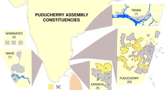
English: Map showing the electoral districts of the Union Territory of
Puducherry, India. Uses
File:Puducherry Map.svg (self made) as a base. Constituency maps for Puducherry and Karaikal recreated from
File:Puducherry-Assembly-Constituencies-1-30-assembly-election-2011.png. |
| Date | 01/03/2021 |
| Source | Own work |
| Author | RaviC |
Licensing
I, the copyright holder of this work, hereby publish it under the following license:
This file is licensed under the
Creative Commons
Attribution-Share Alike 3.0 Unported license.
- You are free:
- to share – to copy, distribute and transmit the work
- to remix – to adapt the work
- Under the following conditions:
- attribution – You must give appropriate credit, provide a link to the license, and indicate if changes were made. You may do so in any reasonable manner, but not in any way that suggests the licensor endorses you or your use.
- share alike – If you remix, transform, or build upon the material, you must distribute your contributions under the same or compatible license as the original.
File history
Click on a date/time to view the file as it appeared at that time.
| Date/Time | Thumbnail | Dimensions | User | Comment | |
|---|---|---|---|---|---|
| current | 15:47, 15 March 2021 |
| 1,493 × 813 (590 KB) | RaviC | Improved constituency boundaries for Puducherry district from File:Wahlkreise zur Vidhan Sabha von Puducherry.svg, added numbering |
| 12:11, 1 March 2021 |
 | 1,493 × 813 (541 KB) | RaviC | more fixes | |
| 12:05, 1 March 2021 |
 | 1,493 × 813 (543 KB) | RaviC | Yanam spelling // Editing SVG source code using c:User:Rillke/SVGedit.js | |
| 12:01, 1 March 2021 |
 | 1,493 × 813 (543 KB) | RaviC | improvements | |
| 11:51, 1 March 2021 |
 | 1,493 × 813 (543 KB) | RaviC | =={{int:filedesc}}== {{Information |description={{en|1=Map showing the electoral districts of the Union Territory of Puducherry, India. Uses File:Puducherry Map.svg (self made) as a base. Constituency maps for Puducherry and Karaikal recreated from Puducherry-Assembly-Constituencies-1-30-assembly-election-2011.png |date=01/03/2021 |source={{own}} |author= RaviC |permission= |other_versions= }} =={{int:license-header}}== {{self|cc-by-sa-3.0}} [[Category:SVG maps... |
File usage
The following pages on the English Wikipedia use this file (pages on other projects are not listed):
Global file usage
The following other wikis use this file:
- Usage on mr.wikipedia.org
- Usage on pnb.wikipedia.org
- Usage on sq.wikipedia.org
- Usage on te.wikipedia.org
- Usage on ur.wikipedia.org
Metadata
Size of this PNG preview of this SVG file:
800 × 436 pixels. Other resolutions:
320 × 174 pixels |
640 × 349 pixels |
1,024 × 558 pixels |
1,280 × 697 pixels |
2,560 × 1,394 pixels |
1,493 × 813 pixels.
Original file (SVG file, nominally 1,493 × 813 pixels, file size: 590 KB)
| This is a file from the
Wikimedia Commons. Information from its
description page there is shown below. Commons is a freely licensed media file repository. You can help. |
Summary
| Description |
English: Map showing the electoral districts of the Union Territory of
Puducherry, India. Uses
File:Puducherry Map.svg (self made) as a base. Constituency maps for Puducherry and Karaikal recreated from
File:Puducherry-Assembly-Constituencies-1-30-assembly-election-2011.png. |
| Date | 01/03/2021 |
| Source | Own work |
| Author | RaviC |
Licensing
I, the copyright holder of this work, hereby publish it under the following license:
This file is licensed under the
Creative Commons
Attribution-Share Alike 3.0 Unported license.
- You are free:
- to share – to copy, distribute and transmit the work
- to remix – to adapt the work
- Under the following conditions:
- attribution – You must give appropriate credit, provide a link to the license, and indicate if changes were made. You may do so in any reasonable manner, but not in any way that suggests the licensor endorses you or your use.
- share alike – If you remix, transform, or build upon the material, you must distribute your contributions under the same or compatible license as the original.
File history
Click on a date/time to view the file as it appeared at that time.
| Date/Time | Thumbnail | Dimensions | User | Comment | |
|---|---|---|---|---|---|
| current | 15:47, 15 March 2021 |
| 1,493 × 813 (590 KB) | RaviC | Improved constituency boundaries for Puducherry district from File:Wahlkreise zur Vidhan Sabha von Puducherry.svg, added numbering |
| 12:11, 1 March 2021 |
| 1,493 × 813 (541 KB) | RaviC | more fixes | |
| 12:05, 1 March 2021 |
| 1,493 × 813 (543 KB) | RaviC | Yanam spelling // Editing SVG source code using c:User:Rillke/SVGedit.js | |
| 12:01, 1 March 2021 |
| 1,493 × 813 (543 KB) | RaviC | improvements | |
| 11:51, 1 March 2021 |
| 1,493 × 813 (543 KB) | RaviC | =={{int:filedesc}}== {{Information |description={{en|1=Map showing the electoral districts of the Union Territory of Puducherry, India. Uses File:Puducherry Map.svg (self made) as a base. Constituency maps for Puducherry and Karaikal recreated from Puducherry-Assembly-Constituencies-1-30-assembly-election-2011.png |date=01/03/2021 |source={{own}} |author= RaviC |permission= |other_versions= }} =={{int:license-header}}== {{self|cc-by-sa-3.0}} [[Category:SVG maps... |
File usage
The following pages on the English Wikipedia use this file (pages on other projects are not listed):
Global file usage
The following other wikis use this file:
- Usage on mr.wikipedia.org
- Usage on pnb.wikipedia.org
- Usage on sq.wikipedia.org
- Usage on te.wikipedia.org
- Usage on ur.wikipedia.org