Size of this preview:
461 × 600 pixels. Other resolutions:
184 × 240 pixels |
471 × 613 pixels.
Original file (471 × 613 pixels, file size: 95 KB, MIME type: image/jpeg)
| This is a file from the
Wikimedia Commons. Information from its
description page there is shown below. Commons is a freely licensed media file repository. You can help. |

|
This biogeographical map image could be re-created using
vector graphics as an
SVG file. This has several advantages; see
Commons:Media for cleanup for more information. If an SVG form of this image is available, please upload it and afterwards replace this template with
{{
vector version available|new image name}}
.
It is recommended to name the SVG file “Ptelea crenulata range map.svg”—then the template Vector version available (or Vva) does not need the new image name parameter. |


Summary
| Description | |
| Date | |
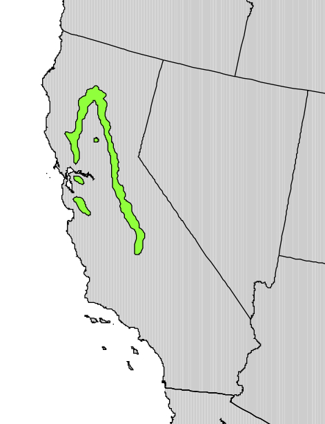
| Source | Digital representation of "Atlas of United States Trees" by Elbert L. Little, Jr. [1] |
| Author | U.S. Geological Survey |
Licensing
This image is in the
public domain in the United States because it only contains materials that originally came from the
United States Geological Survey, an agency of the
United States Department of the Interior. For more information, see
the official USGS copyright policy.
|
Original upload log
Transferred from en.wikipedia to Commons by Pinethicket using CommonsHelper.
The original description page was
here. All following user names refer to en.wikipedia.
- 2012-10-09 12:37 Pinethicket 471×613× (97175 bytes) {{Information |Description=Range map of ''Ptelea crenulata'' |Source=Digital representation of "Atlas of United States Trees" by Elbert L. Little, Jr. [http://esp.cr.usgs.gov/data/atlas/little/] |Date=1999 |Author=U.S. Geological Survey ...
File history
Click on a date/time to view the file as it appeared at that time.
| Date/Time | Thumbnail | Dimensions | User | Comment | |
|---|---|---|---|---|---|
| current | 16:08, 9 October 2012 |
| 471 × 613 (95 KB) | File Upload Bot (Magnus Manske) | Transfered from en.wikipedia by User:Pinethicket using CommonsHelper |
File usage
The following pages on the English Wikipedia use this file (pages on other projects are not listed):
Global file usage
The following other wikis use this file:
- Usage on ceb.wikipedia.org
Metadata
Size of this preview:
461 × 600 pixels. Other resolutions:
184 × 240 pixels |
471 × 613 pixels.
Original file (471 × 613 pixels, file size: 95 KB, MIME type: image/jpeg)
| This is a file from the
Wikimedia Commons. Information from its
description page there is shown below. Commons is a freely licensed media file repository. You can help. |
|
|
This biogeographical map image could be re-created using
vector graphics as an
SVG file. This has several advantages; see
Commons:Media for cleanup for more information. If an SVG form of this image is available, please upload it and afterwards replace this template with
{{
vector version available|new image name}}
.
It is recommended to name the SVG file “Ptelea crenulata range map.svg”—then the template Vector version available (or Vva) does not need the new image name parameter. |
Summary
| Description | |
| Date | |
| Source | Digital representation of "Atlas of United States Trees" by Elbert L. Little, Jr. [1] |
| Author | U.S. Geological Survey |
Licensing
This image is in the
public domain in the United States because it only contains materials that originally came from the
United States Geological Survey, an agency of the
United States Department of the Interior. For more information, see
the official USGS copyright policy.
|
Original upload log
Transferred from en.wikipedia to Commons by Pinethicket using CommonsHelper.
The original description page was
here. All following user names refer to en.wikipedia.
- 2012-10-09 12:37 Pinethicket 471×613× (97175 bytes) {{Information |Description=Range map of ''Ptelea crenulata'' |Source=Digital representation of "Atlas of United States Trees" by Elbert L. Little, Jr. [http://esp.cr.usgs.gov/data/atlas/little/] |Date=1999 |Author=U.S. Geological Survey ...
File history
Click on a date/time to view the file as it appeared at that time.
| Date/Time | Thumbnail | Dimensions | User | Comment | |
|---|---|---|---|---|---|
| current | 16:08, 9 October 2012 |
| 471 × 613 (95 KB) | File Upload Bot (Magnus Manske) | Transfered from en.wikipedia by User:Pinethicket using CommonsHelper |
File usage
The following pages on the English Wikipedia use this file (pages on other projects are not listed):
Global file usage
The following other wikis use this file:
- Usage on ceb.wikipedia.org