
Original file (5,990 × 4,088 pixels, file size: 70.06 MB, MIME type: image/tiff)
| This is a file from the
Wikimedia Commons. Information from its
description page there is shown below. Commons is a freely licensed media file repository. You can help. |
Summary
| Description |
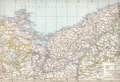
English: Map of the Prussian province of Pommern (Pomerania) in 1880. Attention: The adjacent province of Westpreußen (Western Prussia) included also territories that before 1772 had been part of Greater Poland. |
| Date | print 1880, scan 2018-04-13 |
| Source | Andrees Handatlas |
| Author | onknown, scan & upload Ulamm ( talk) |
Licensing
|
This work is in the public domain in its country of origin and other countries and areas where the copyright term is the author's life plus 100 years or fewer. This work is in the public domain in the United States because it was published (or registered with the U.S. Copyright Office) before January 1, 1929. | |
| This file has been identified as being free of known restrictions under copyright law, including all related and neighboring rights. | |
File history
Click on a date/time to view the file as it appeared at that time.
| Date/Time | Thumbnail | Dimensions | User | Comment | |
|---|---|---|---|---|---|
| current | 13:00, 13 April 2018 |
 | 5,990 × 4,088 (70.06 MB) | Ulamm | {{Information |Description={{en|Map of the Prussian province of Pommern (Pomerania) in 1880. Attention: The adjacent province of Westpreußen (Western Prussia) included also territories that before 1772 had been part of Greater Poland.}} |Source=Andrees Handatlas |Date=print 1880, scan 2018-04-13 |Author=onknown, scan & upload ~~~ |Permission= |other_versions= }} Category:Maps of Mecklenburg-Schwerin Category:Maps of Mecklenburg-Strelitz Category:1880 maps [[Category:Andree's Hand... |
File usage
Global file usage
The following other wikis use this file:
Metadata
Original file (5,990 × 4,088 pixels, file size: 70.06 MB, MIME type: image/tiff)
| This is a file from the
Wikimedia Commons. Information from its
description page there is shown below. Commons is a freely licensed media file repository. You can help. |
Summary
| Description |
English: Map of the Prussian province of Pommern (Pomerania) in 1880. Attention: The adjacent province of Westpreußen (Western Prussia) included also territories that before 1772 had been part of Greater Poland. |
| Date | print 1880, scan 2018-04-13 |
| Source | Andrees Handatlas |
| Author | onknown, scan & upload Ulamm ( talk) |
Licensing
|
This work is in the public domain in its country of origin and other countries and areas where the copyright term is the author's life plus 100 years or fewer. This work is in the public domain in the United States because it was published (or registered with the U.S. Copyright Office) before January 1, 1929. | |
| This file has been identified as being free of known restrictions under copyright law, including all related and neighboring rights. | |
File history
Click on a date/time to view the file as it appeared at that time.
| Date/Time | Thumbnail | Dimensions | User | Comment | |
|---|---|---|---|---|---|
| current | 13:00, 13 April 2018 |
| 5,990 × 4,088 (70.06 MB) | Ulamm | {{Information |Description={{en|Map of the Prussian province of Pommern (Pomerania) in 1880. Attention: The adjacent province of Westpreußen (Western Prussia) included also territories that before 1772 had been part of Greater Poland.}} |Source=Andrees Handatlas |Date=print 1880, scan 2018-04-13 |Author=onknown, scan & upload ~~~ |Permission= |other_versions= }} Category:Maps of Mecklenburg-Schwerin Category:Maps of Mecklenburg-Strelitz Category:1880 maps [[Category:Andree's Hand... |
File usage
Global file usage
The following other wikis use this file: