
Size of this preview:
800 × 459 pixels. Other resolutions:
320 × 184 pixels |
640 × 367 pixels |
1,024 × 587 pixels |
1,280 × 734 pixels |
2,560 × 1,468 pixels |
11,597 × 6,651 pixels.
Original file (11,597 × 6,651 pixels, file size: 13.09 MB, MIME type: image/jpeg)
| This is a file from the
Wikimedia Commons. Information from its
description page there is shown below. Commons is a freely licensed media file repository. You can help. |
Summary
| Description |
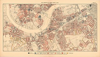
English: Covering: Battersea, Nine Elms, Clapham, Wandsworth, Balham, Putney, West Hill, Walham Green, Parsons Green and Fulham.
|
| Date | |
| Source | https://www.flickr.com/photos/lselibrary/22128198814/ |
| Author | LSE Library |
| Permission ( Reusing this file) |
At the time of upload, the image license was automatically confirmed using the Flickr API. For more information see Flickr API detail. |
| Other versions | |
| Flickr sets |
|
| Flickr tags |
|

.jpg)
Licensing
This image was taken from
Flickr's
The Commons. The uploading organization may have various reasons for determining that no known copyright restrictions exist, such as:
More information can be found at https://flickr.com/commons/usage/. Please add additional copyright tags to this image if more specific information about copyright status can be determined. See Commons:Licensing for more information. |
| This image was originally posted to Flickr by LSE Library at https://flickr.com/photos/35128489@N07/22128198814. It was reviewed on 2 October 2016 by FlickreviewR and was confirmed to be licensed under the terms of the No known copyright restrictions. |
File history
Click on a date/time to view the file as it appeared at that time.
| Date/Time | Thumbnail | Dimensions | User | Comment | |
|---|---|---|---|---|---|
| current | 14:45, 2 October 2016 |
| 11,597 × 6,651 (13.09 MB) | Fæ | LSE Library, Set 72157658449873093, ID 22128198814, Original title Printed Map Descriptive of London Poverty 1898-1899. Sheet 10. South West District |
File usage
The following pages on the English Wikipedia use this file (pages on other projects are not listed):
.jpg)
Size of this preview:
800 × 459 pixels. Other resolutions:
320 × 184 pixels |
640 × 367 pixels |
1,024 × 587 pixels |
1,280 × 734 pixels |
2,560 × 1,468 pixels |
11,597 × 6,651 pixels.
Original file (11,597 × 6,651 pixels, file size: 13.09 MB, MIME type: image/jpeg)
| This is a file from the
Wikimedia Commons. Information from its
description page there is shown below. Commons is a freely licensed media file repository. You can help. |
Summary
| Description |
English: Covering: Battersea, Nine Elms, Clapham, Wandsworth, Balham, Putney, West Hill, Walham Green, Parsons Green and Fulham.
|
| Date | |
| Source | https://www.flickr.com/photos/lselibrary/22128198814/ |
| Author | LSE Library |
| Permission ( Reusing this file) |
At the time of upload, the image license was automatically confirmed using the Flickr API. For more information see Flickr API detail. |
| Other versions | |
| Flickr sets |
|
| Flickr tags |
|
Licensing
This image was taken from
Flickr's
The Commons. The uploading organization may have various reasons for determining that no known copyright restrictions exist, such as:
More information can be found at https://flickr.com/commons/usage/. Please add additional copyright tags to this image if more specific information about copyright status can be determined. See Commons:Licensing for more information. |
| This image was originally posted to Flickr by LSE Library at https://flickr.com/photos/35128489@N07/22128198814. It was reviewed on 2 October 2016 by FlickreviewR and was confirmed to be licensed under the terms of the No known copyright restrictions. |
File history
Click on a date/time to view the file as it appeared at that time.
| Date/Time | Thumbnail | Dimensions | User | Comment | |
|---|---|---|---|---|---|
| current | 14:45, 2 October 2016 |
| 11,597 × 6,651 (13.09 MB) | Fæ | LSE Library, Set 72157658449873093, ID 22128198814, Original title Printed Map Descriptive of London Poverty 1898-1899. Sheet 10. South West District |
File usage
The following pages on the English Wikipedia use this file (pages on other projects are not listed):