Photos • Location


No higher resolution available.
Prince_Charles_Quay,_Cardigan_-_geograph.org.uk_-_744916.jpg (640 × 427 pixels, file size: 65 KB, MIME type: image/jpeg)
| This is a file from the
Wikimedia Commons. Information from its
description page there is shown below. Commons is a freely licensed media file repository. You can help. |
Summary
| Description |
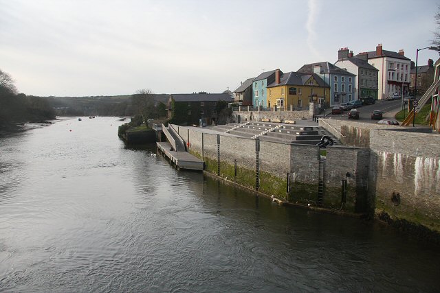
English: Prince Charles Quay, Cardigan Formerly known as Lloyds Wharf, this quay has been re-built with the aid of Objective 1 funding. It was formally opened in July 2007. The aim is to re-open a port that has suffered a hundred years of decline and neglect; 200 years ago many people left from this quay for a new life in America. |
| Date | |
| Source | From geograph.org.uk |
| Author | Bob Jones |
| Attribution ( required by the license) | Bob Jones / Prince Charles Quay, Cardigan / |
| Openstreetmap entry | Link to Openstreetmap |
| Camera location | | View this and other nearby images on: OpenStreetMap |
|
|---|
_heading:315.00&language=en)
| Object location | | View this and other nearby images on: OpenStreetMap |
|
|---|
_heading:315.00&language=en)
Licensing

|
This image was taken from the
Geograph project collection. See
this photograph's page on the Geograph website for the photographer's contact details. The copyright on this image is owned by Bob Jones and is licensed for reuse under the
Creative Commons Attribution-ShareAlike 2.0 license.
|
This file is licensed under the
Creative Commons
Attribution-Share Alike 2.0 Generic license.
Attribution: Bob Jones
- You are free:
- to share – to copy, distribute and transmit the work
- to remix – to adapt the work
- Under the following conditions:
- attribution – You must give appropriate credit, provide a link to the license, and indicate if changes were made. You may do so in any reasonable manner, but not in any way that suggests the licensor endorses you or your use.
- share alike – If you remix, transform, or build upon the material, you must distribute your contributions under the same or compatible license as the original.
File history
Click on a date/time to view the file as it appeared at that time.
| Date/Time | Thumbnail | Dimensions | User | Comment | |
|---|---|---|---|---|---|
| current | 12:17, 19 February 2011 |
| 640 × 427 (65 KB) | GeographBot | == {{int:filedesc}} == {{Information |description={{en|1=Prince Charles Quay, Cardigan Formerly known as Lloyds Wharf, this quay has been re-built with the aid of Objective 1 funding. It was formally opened in July 2007. The aim is to re-open a port that |
File usage
The following pages on the English Wikipedia use this file (pages on other projects are not listed):
Global file usage
The following other wikis use this file:
- Usage on fa.wikipedia.org
Metadata
No higher resolution available.
Prince_Charles_Quay,_Cardigan_-_geograph.org.uk_-_744916.jpg (640 × 427 pixels, file size: 65 KB, MIME type: image/jpeg)
| This is a file from the
Wikimedia Commons. Information from its
description page there is shown below. Commons is a freely licensed media file repository. You can help. |
Summary
| Description |
English: Prince Charles Quay, Cardigan Formerly known as Lloyds Wharf, this quay has been re-built with the aid of Objective 1 funding. It was formally opened in July 2007. The aim is to re-open a port that has suffered a hundred years of decline and neglect; 200 years ago many people left from this quay for a new life in America. |
| Date | |
| Source | From geograph.org.uk |
| Author | Bob Jones |
| Attribution ( required by the license) | Bob Jones / Prince Charles Quay, Cardigan / |
| Openstreetmap entry | Link to Openstreetmap |
| Camera location | | View this and other nearby images on: OpenStreetMap |
|
|---|
| Object location | | View this and other nearby images on: OpenStreetMap |
|
|---|
Licensing
|
|
This image was taken from the
Geograph project collection. See
this photograph's page on the Geograph website for the photographer's contact details. The copyright on this image is owned by Bob Jones and is licensed for reuse under the
Creative Commons Attribution-ShareAlike 2.0 license.
|
This file is licensed under the
Creative Commons
Attribution-Share Alike 2.0 Generic license.
Attribution: Bob Jones
- You are free:
- to share – to copy, distribute and transmit the work
- to remix – to adapt the work
- Under the following conditions:
- attribution – You must give appropriate credit, provide a link to the license, and indicate if changes were made. You may do so in any reasonable manner, but not in any way that suggests the licensor endorses you or your use.
- share alike – If you remix, transform, or build upon the material, you must distribute your contributions under the same or compatible license as the original.
File history
Click on a date/time to view the file as it appeared at that time.
| Date/Time | Thumbnail | Dimensions | User | Comment | |
|---|---|---|---|---|---|
| current | 12:17, 19 February 2011 |
| 640 × 427 (65 KB) | GeographBot | == {{int:filedesc}} == {{Information |description={{en|1=Prince Charles Quay, Cardigan Formerly known as Lloyds Wharf, this quay has been re-built with the aid of Objective 1 funding. It was formally opened in July 2007. The aim is to re-open a port that |
File usage
The following pages on the English Wikipedia use this file (pages on other projects are not listed):
Global file usage
The following other wikis use this file:
- Usage on fa.wikipedia.org