Position_of_Tasman_Region.png (405 × 590 pixels, file size: 7 KB, MIME type: image/png)
| This is a file from the
Wikimedia Commons. Information from its
description page there is shown below. Commons is a freely licensed media file repository. You can help. |
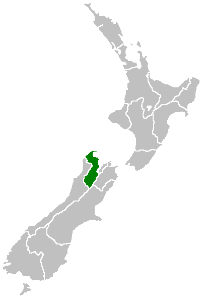
Region of New Zealand, position on the map (source:English Wiki)
| |
This work has been released into the
public domain by its author,
Furius, at the
English Wikipedia project. This applies worldwide. In case this is not legally possible: |
File history
Click on a date/time to view the file as it appeared at that time.
| Date/Time | Thumbnail | Dimensions | User | Comment | |
|---|---|---|---|---|---|
| current | 07:41, 27 April 2005 |
| 405 × 590 (7 KB) | Domie~commonswiki | Region of New Zealand, position on the map (source:English Wiki) {{PD}} Category:Maps of New Zealand |
File usage
- Abel Tasman Inland Track
- Armchair Island
- Awaroa River (Tasman)
- Ballon Rock
- Bell Island (New Zealand)
- Bird Island (Tasman Region)
- Bronte, New Zealand
- Brown River (Tasman)
- Bulmer Cavern
- Cape Farewell, New Zealand
- Collingwood County
- Dovedale, New Zealand
- Ellis Basin cave system
- Golden Bay County
- Golden Bay Ward
- Granity Pass
- Hope Saddle
- Kahurangi Point
- Lake Constance (New Zealand)
- Lake Matiri
- Lake Rotoroa (Tasman)
- Lake Sparrow
- Lakes-Murchison Ward
- Mahana, New Zealand
- Matiri Project
- Motuareronui / Adele Island
- Motueka Ward
- Motupipi
- Mount Franklin (Tasman)
- Mount Owen (New Zealand)
- Moutere-Waimea Ward
- Murchison County, New Zealand
- Ngārua Caves
- Patons Rock
- Pūponga
- Richmond Ward
- Rotoiti Mainland Island
- Rotoroa, New Zealand
- Sabine Valley
- Saint Arnaud Range
- Spenser Mountains
- Split Apple Rock
- Takaka County
- Tinline Bay
- Tonga Island
- Upper Tākaka
- Waimea County
- Waimea Inlet
- Woodstock, Tasman
- User:MSGJ/Wairoa River, Tasman
- Template:Tasman-geo-stub
Global file usage
The following other wikis use this file:
- Usage on eu.wikipedia.org
- Usage on fi.wikipedia.org
- Usage on gd.wikipedia.org
- Usage on hi.wikipedia.org
- Usage on ja.wikipedia.org
- Usage on ko.wikipedia.org
- Usage on nn.wikipedia.org
- Usage on pl.wikipedia.org
- Usage on pnb.wikipedia.org
- Usage on ru.wikipedia.org
- Usage on sh.wikipedia.org
- Usage on sv.wikipedia.org
- Usage on uk.wikipedia.org
- Usage on www.wikidata.org
- Usage on zh.wikipedia.org
Position_of_Tasman_Region.png (405 × 590 pixels, file size: 7 KB, MIME type: image/png)
| This is a file from the
Wikimedia Commons. Information from its
description page there is shown below. Commons is a freely licensed media file repository. You can help. |
Region of New Zealand, position on the map (source:English Wiki)
| |
This work has been released into the
public domain by its author,
Furius, at the
English Wikipedia project. This applies worldwide. In case this is not legally possible: |
File history
Click on a date/time to view the file as it appeared at that time.
| Date/Time | Thumbnail | Dimensions | User | Comment | |
|---|---|---|---|---|---|
| current | 07:41, 27 April 2005 |
| 405 × 590 (7 KB) | Domie~commonswiki | Region of New Zealand, position on the map (source:English Wiki) {{PD}} Category:Maps of New Zealand |
File usage
- Abel Tasman Inland Track
- Armchair Island
- Awaroa River (Tasman)
- Ballon Rock
- Bell Island (New Zealand)
- Bird Island (Tasman Region)
- Bronte, New Zealand
- Brown River (Tasman)
- Bulmer Cavern
- Cape Farewell, New Zealand
- Collingwood County
- Dovedale, New Zealand
- Ellis Basin cave system
- Golden Bay County
- Golden Bay Ward
- Granity Pass
- Hope Saddle
- Kahurangi Point
- Lake Constance (New Zealand)
- Lake Matiri
- Lake Rotoroa (Tasman)
- Lake Sparrow
- Lakes-Murchison Ward
- Mahana, New Zealand
- Matiri Project
- Motuareronui / Adele Island
- Motueka Ward
- Motupipi
- Mount Franklin (Tasman)
- Mount Owen (New Zealand)
- Moutere-Waimea Ward
- Murchison County, New Zealand
- Ngārua Caves
- Patons Rock
- Pūponga
- Richmond Ward
- Rotoiti Mainland Island
- Rotoroa, New Zealand
- Sabine Valley
- Saint Arnaud Range
- Spenser Mountains
- Split Apple Rock
- Takaka County
- Tinline Bay
- Tonga Island
- Upper Tākaka
- Waimea County
- Waimea Inlet
- Woodstock, Tasman
- User:MSGJ/Wairoa River, Tasman
- Template:Tasman-geo-stub
Global file usage
The following other wikis use this file:
- Usage on eu.wikipedia.org
- Usage on fi.wikipedia.org
- Usage on gd.wikipedia.org
- Usage on hi.wikipedia.org
- Usage on ja.wikipedia.org
- Usage on ko.wikipedia.org
- Usage on nn.wikipedia.org
- Usage on pl.wikipedia.org
- Usage on pnb.wikipedia.org
- Usage on ru.wikipedia.org
- Usage on sh.wikipedia.org
- Usage on sv.wikipedia.org
- Usage on uk.wikipedia.org
- Usage on www.wikidata.org
- Usage on zh.wikipedia.org