
Size of this PNG preview of this SVG file:
357 × 297 pixels. Other resolutions:
289 × 240 pixels |
577 × 480 pixels |
923 × 768 pixels |
1,231 × 1,024 pixels |
2,462 × 2,048 pixels.
Original file (SVG file, nominally 357 × 297 pixels, file size: 196 KB)
| This is a file from the
Wikimedia Commons. Information from its
description page there is shown below. Commons is a freely licensed media file repository. You can help. |
Summary
| Description |
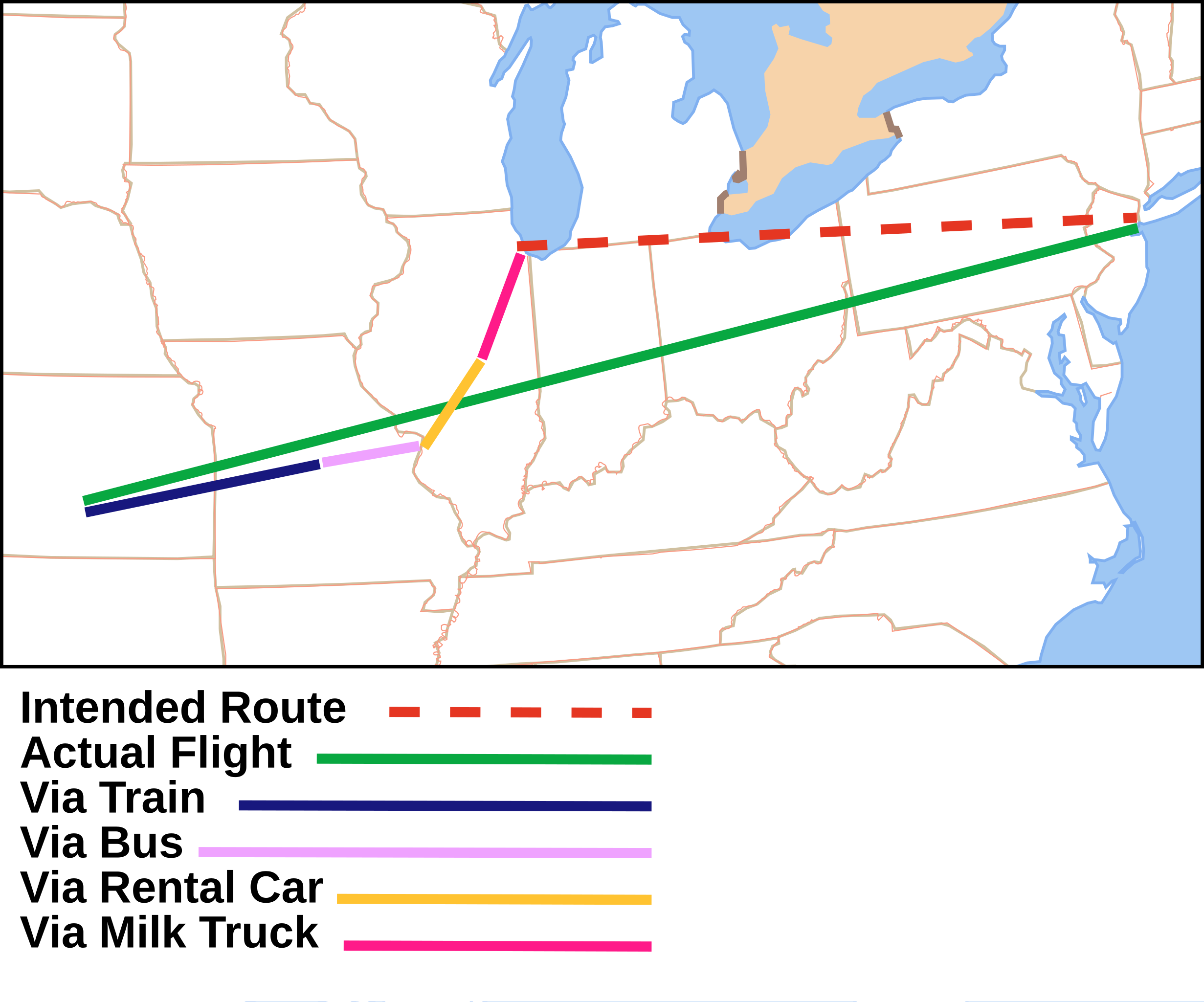
English: Route taken by Del Griffin and Neal Page in the movie
Planes, Trains and Automobiles
|
||
| Date | |||
| Source | Own based on: File:Map of USA without state names.svg | ||
| Author |
Vector: |
||
| Permission ( Reusing this file) |
Ichabod, the copyright holder of this work, hereby publishes it under the following licenses: This file is licensed under the
Creative Commons
Attribution-Share Alike 3.0 Unported license. Attribution:
Ichabod
You may select the license of your choice. |
||
| SVG development |

File history
Click on a date/time to view the file as it appeared at that time.
| Date/Time | Thumbnail | Dimensions | User | Comment | |
|---|---|---|---|---|---|
| current | 03:59, 8 July 2024 |
| 357 × 297 (196 KB) | TheWanderingTraders | == {{int:filedesc}} == {{Information |Description={{en|1=Route taken by Del Griffin and Neal Page in the movie Planes, Trains and Automobiles * Red dotted line - Intended route New York to Chicago via plane * Green line - Actual flight - A snowstorm in Chicago closes the airport forcing the plane to be rerouted to Wichita, Kansas. * Dark blue line - "People Train" from the fictional Stubbville, Kansas, (a little further from Wichita). Train breaks down so... |
File usage
The following pages on the English Wikipedia use this file (pages on other projects are not listed):
Global file usage
The following other wikis use this file:
- Usage on de.wikipedia.org
- Usage on hu.wikipedia.org
- Usage on ro.wikipedia.org
- Usage on ru.wikipedia.org
- Usage on sh.wikipedia.org
Metadata
Size of this PNG preview of this SVG file:
357 × 297 pixels. Other resolutions:
289 × 240 pixels |
577 × 480 pixels |
923 × 768 pixels |
1,231 × 1,024 pixels |
2,462 × 2,048 pixels.
Original file (SVG file, nominally 357 × 297 pixels, file size: 196 KB)
| This is a file from the
Wikimedia Commons. Information from its
description page there is shown below. Commons is a freely licensed media file repository. You can help. |
Summary
| Description |
English: Route taken by Del Griffin and Neal Page in the movie
Planes, Trains and Automobiles
|
||
| Date | |||
| Source | Own based on: File:Map of USA without state names.svg | ||
| Author |
Vector: |
||
| Permission ( Reusing this file) |
Ichabod, the copyright holder of this work, hereby publishes it under the following licenses: This file is licensed under the
Creative Commons
Attribution-Share Alike 3.0 Unported license. Attribution:
Ichabod
You may select the license of your choice. |
||
| SVG development |
File history
Click on a date/time to view the file as it appeared at that time.
| Date/Time | Thumbnail | Dimensions | User | Comment | |
|---|---|---|---|---|---|
| current | 03:59, 8 July 2024 |
| 357 × 297 (196 KB) | TheWanderingTraders | == {{int:filedesc}} == {{Information |Description={{en|1=Route taken by Del Griffin and Neal Page in the movie Planes, Trains and Automobiles * Red dotted line - Intended route New York to Chicago via plane * Green line - Actual flight - A snowstorm in Chicago closes the airport forcing the plane to be rerouted to Wichita, Kansas. * Dark blue line - "People Train" from the fictional Stubbville, Kansas, (a little further from Wichita). Train breaks down so... |
File usage
The following pages on the English Wikipedia use this file (pages on other projects are not listed):
Global file usage
The following other wikis use this file:
- Usage on de.wikipedia.org
- Usage on hu.wikipedia.org
- Usage on ro.wikipedia.org
- Usage on ru.wikipedia.org
- Usage on sh.wikipedia.org