Size of this preview:
780 × 600 pixels. Other resolutions:
312 × 240 pixels |
624 × 480 pixels |
940 × 723 pixels.
Original file (940 × 723 pixels, file size: 45 KB, MIME type: image/png)
| This is a file from the
Wikimedia Commons. Information from its
description page there is shown below. Commons is a freely licensed media file repository. You can help. |
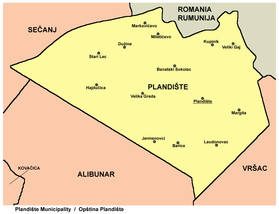
map of Plandište municipality (self made)
| I, the copyright holder of this work, release this work into the
public domain. This applies worldwide. In some countries this may not be legally possible; if so: I grant anyone the right to use this work for any purpose, without any conditions, unless such conditions are required by law. |
File history
Click on a date/time to view the file as it appeared at that time.
| Date/Time | Thumbnail | Dimensions | User | Comment | |
|---|---|---|---|---|---|
| current | 19:30, 21 March 2013 |
| 940 × 723 (45 KB) | PANONIAN | {{Information |Description ={{en|1=improved version}} |Source =improved version |Author =improved version |Date = |Permission = |other_versions = }} |
| 14:08, 23 February 2009 |
 | 900 × 684 (36 KB) | PANONIAN | map of Plandište municipality (self made) {{PD-self}} Category:Maps of municipalities of Vojvodina Category:Plandište |
File usage
The following pages on the English Wikipedia use this file (pages on other projects are not listed):
Global file usage
The following other wikis use this file:
- Usage on eo.wikipedia.org
- Usage on fr.wikipedia.org
- Usage on hr.wikipedia.org
- Usage on hu.wikipedia.org
- Usage on mk.wikipedia.org
- Usage on sh.wikipedia.org
- Usage on sq.wikipedia.org
- Usage on sr.wikipedia.org
- Usage on uk.wikipedia.org
Size of this preview:
780 × 600 pixels. Other resolutions:
312 × 240 pixels |
624 × 480 pixels |
940 × 723 pixels.
Original file (940 × 723 pixels, file size: 45 KB, MIME type: image/png)
| This is a file from the
Wikimedia Commons. Information from its
description page there is shown below. Commons is a freely licensed media file repository. You can help. |
map of Plandište municipality (self made)
| I, the copyright holder of this work, release this work into the
public domain. This applies worldwide. In some countries this may not be legally possible; if so: I grant anyone the right to use this work for any purpose, without any conditions, unless such conditions are required by law. |
File history
Click on a date/time to view the file as it appeared at that time.
| Date/Time | Thumbnail | Dimensions | User | Comment | |
|---|---|---|---|---|---|
| current | 19:30, 21 March 2013 |
| 940 × 723 (45 KB) | PANONIAN | {{Information |Description ={{en|1=improved version}} |Source =improved version |Author =improved version |Date = |Permission = |other_versions = }} |
| 14:08, 23 February 2009 |
| 900 × 684 (36 KB) | PANONIAN | map of Plandište municipality (self made) {{PD-self}} Category:Maps of municipalities of Vojvodina Category:Plandište |
File usage
The following pages on the English Wikipedia use this file (pages on other projects are not listed):
Global file usage
The following other wikis use this file:
- Usage on eo.wikipedia.org
- Usage on fr.wikipedia.org
- Usage on hr.wikipedia.org
- Usage on hu.wikipedia.org
- Usage on mk.wikipedia.org
- Usage on sh.wikipedia.org
- Usage on sq.wikipedia.org
- Usage on sr.wikipedia.org
- Usage on uk.wikipedia.org