Photos • Location


Size of this preview:
800 × 533 pixels. Other resolutions:
320 × 213 pixels |
640 × 427 pixels |
1,024 × 683 pixels |
1,280 × 853 pixels |
2,560 × 1,707 pixels |
3,888 × 2,592 pixels.
Original file (3,888 × 2,592 pixels, file size: 3.63 MB, MIME type: image/jpeg)
| This is a file from the
Wikimedia Commons. Information from its
description page there is shown below. Commons is a freely licensed media file repository. You can help. |
Summary
| Description |
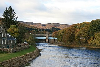
English: Pitlochry hydro-electric power station and the River Tummel. The Power Station dams the river creating Loch Faskally. |
| Date | |
| Source | Own work |
| Author | RobChafer |
| Camera location |
| View this and other nearby images on: OpenStreetMap |
|
|---|
Licensing
| I, the copyright holder of this work, release this work into the
public domain. This applies worldwide. In some countries this may not be legally possible; if so: I grant anyone the right to use this work for any purpose, without any conditions, unless such conditions are required by law. |
File history
Click on a date/time to view the file as it appeared at that time.
| Date/Time | Thumbnail | Dimensions | User | Comment | |
|---|---|---|---|---|---|
| current | 13:06, 8 November 2008 |
| 3,888 × 2,592 (3.63 MB) | RobChafer | {{Information |Description={{en|1=Pitlochry hydro-electric power station and the River Tummel. The Power Station dams the river creating Loch Faskally.}} |Source=Own work by uploader |Author= RobChafer |Date=October 30, 2008 |Permission= |
File usage
The following pages on the English Wikipedia use this file (pages on other projects are not listed):
Global file usage
The following other wikis use this file:
- Usage on de.wikipedia.org
- Usage on gd.wikipedia.org
Metadata
Size of this preview:
800 × 533 pixels. Other resolutions:
320 × 213 pixels |
640 × 427 pixels |
1,024 × 683 pixels |
1,280 × 853 pixels |
2,560 × 1,707 pixels |
3,888 × 2,592 pixels.
Original file (3,888 × 2,592 pixels, file size: 3.63 MB, MIME type: image/jpeg)
| This is a file from the
Wikimedia Commons. Information from its
description page there is shown below. Commons is a freely licensed media file repository. You can help. |
Summary
| Description |
English: Pitlochry hydro-electric power station and the River Tummel. The Power Station dams the river creating Loch Faskally. |
| Date | |
| Source | Own work |
| Author | RobChafer |
| Camera location |
| View this and other nearby images on: OpenStreetMap |
|
|---|
Licensing
| I, the copyright holder of this work, release this work into the
public domain. This applies worldwide. In some countries this may not be legally possible; if so: I grant anyone the right to use this work for any purpose, without any conditions, unless such conditions are required by law. |
File history
Click on a date/time to view the file as it appeared at that time.
| Date/Time | Thumbnail | Dimensions | User | Comment | |
|---|---|---|---|---|---|
| current | 13:06, 8 November 2008 |
| 3,888 × 2,592 (3.63 MB) | RobChafer | {{Information |Description={{en|1=Pitlochry hydro-electric power station and the River Tummel. The Power Station dams the river creating Loch Faskally.}} |Source=Own work by uploader |Author= RobChafer |Date=October 30, 2008 |Permission= |
File usage
The following pages on the English Wikipedia use this file (pages on other projects are not listed):
Global file usage
The following other wikis use this file:
- Usage on de.wikipedia.org
- Usage on gd.wikipedia.org