PissPotIsland.JPG (300 × 348 pixels, file size: 31 KB, MIME type: image/jpeg)
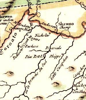
Piss Pot Island listed on the 1755 Jefferson and Fry Map in the South Branch Potomac River.
| This image is in the public domain in the United States. In most cases, this means that it was first published prior to January 1, 1929 (see the template documentation for more cases). Other jurisdictions may have other rules, and this image might not be in the public domain outside the United States. See Wikipedia:Public domain and Wikipedia:Copyrights for more details. |
|
 | This file is a candidate to be copied to
Wikimedia Commons.
Any user may perform this transfer; refer to Wikipedia:Moving files to Commons for details. If this file has problems with attribution, copyright, or is otherwise ineligible for Commons, then remove this tag and DO NOT transfer it; repeat violators may be blocked from editing. Other Instructions
| ||
| |||
File history
Click on a date/time to view the file as it appeared at that time.
| Date/Time | Thumbnail | Dimensions | User | Comment | |
|---|---|---|---|---|---|
| current | 03:12, 27 December 2005 |
| 300 × 348 (31 KB) | West Virginian ( talk | contribs) | Piss Pot Island listed on the 1755 Jefferson and Fry Map in the South Branch Potomac River. |
You cannot overwrite this file.
File usage
Metadata
PissPotIsland.JPG (300 × 348 pixels, file size: 31 KB, MIME type: image/jpeg)
Piss Pot Island listed on the 1755 Jefferson and Fry Map in the South Branch Potomac River.
| This image is in the public domain in the United States. In most cases, this means that it was first published prior to January 1, 1929 (see the template documentation for more cases). Other jurisdictions may have other rules, and this image might not be in the public domain outside the United States. See Wikipedia:Public domain and Wikipedia:Copyrights for more details. |
|
|
| This file is a candidate to be copied to
Wikimedia Commons.
Any user may perform this transfer; refer to Wikipedia:Moving files to Commons for details. If this file has problems with attribution, copyright, or is otherwise ineligible for Commons, then remove this tag and DO NOT transfer it; repeat violators may be blocked from editing. Other Instructions
| ||
| |||
File history
Click on a date/time to view the file as it appeared at that time.
| Date/Time | Thumbnail | Dimensions | User | Comment | |
|---|---|---|---|---|---|
| current | 03:12, 27 December 2005 |
| 300 × 348 (31 KB) | West Virginian ( talk | contribs) | Piss Pot Island listed on the 1755 Jefferson and Fry Map in the South Branch Potomac River. |
You cannot overwrite this file.