Ph_map_siquijor.png (600 × 575 pixels, file size: 41 KB, MIME type: image/png)
| This is a file from the
Wikimedia Commons. Information from its
description page there is shown below. Commons is a freely licensed media file repository. You can help. |
This image was copied from wikipedia:tl. The original description was:
| Description |
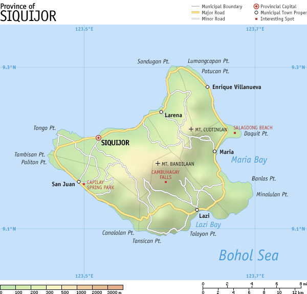
Map of en:Siquijor, en:Philippines. It is a topographic map showing the six municipalities, major and some minor roads, and notable places of interest. Created and copyright (2003) by seav. Released under the GNU FDL. |
| Date | 28 June 2003 (original upload date) |
| Source | Transferred from en.wikipedia to Commons. |
| Author | The original uploader was Seav at English Wikipedia. |
Licensing
| This file is licensed under the Creative Commons Attribution-Share Alike 3.0 Unported license. Subject to disclaimers. | ||
| ||
| This licensing tag was added to this file as part of the GFDL licensing update. |

|
Permission is granted to copy, distribute and/or modify this document under the terms of the GNU Free Documentation License, Version 1.2 or any later version published by the Free Software Foundation; with no Invariant Sections, no Front-Cover Texts, and no Back-Cover Texts. A copy of the license is included in the section entitled GNU Free Documentation License. Subject to disclaimers. |
Original upload log
- 2003-06-28 01:12 Seav 600×575×8 (42071 bytes) Map of [[Siquijor]], [[Philippines]].
| date/time | username | resolution | size | edit summary | |
|---|---|---|---|---|---|
| 11:04, 21 Marso 2007 | Mananaliksik | <a href=" http://upload.wikimedia.org/wikipedia/tl/a/ad/Ph_map_siquijor.png"><img alt="Thumbnail for version as of 11:04, 21 Marso 2007" src=" http://upload.wikimedia.org/wikipedia/tl/thumb/a/ad/Ph_map_siquijor.png/120px-Ph_map_siquijor.png" width="120" height="115" border="0" /></a> | 600×575 | 41 KB | Created and copyright (2003) by <a href="/info/en/?search=User:Seav" title="User:Seav">seav</a>. Released under the <a href="/info/en/?search=GNU_Free_Documentation_License" title="GNU Free Documentation License">GNU FDL</a>. {{GFDL}} |
File history
Click on a date/time to view the file as it appeared at that time.
| Date/Time | Thumbnail | Dimensions | User | Comment | |
|---|---|---|---|---|---|
| current | 14:41, 19 September 2008 |
| 600 × 575 (41 KB) | AiraBot | This image was copied from wikipedia:tl. The original description was: {{Information |Description=Map of en:Siquijor, en:Philippines. It is a topographic map showing the six municipalities, major and some minor roads, and notable places of inte |
File usage
Global file usage
The following other wikis use this file:
- Usage on ceb.wikipedia.org
- Usage on de.wikipedia.org
- Usage on es.wikipedia.org
- Usage on hi.wikipedia.org
- Usage on la.wikipedia.org
- Usage on mk.wikipedia.org
- Usage on pam.wikipedia.org
- Usage on ru.wikipedia.org
- Usage on simple.wikipedia.org
- Usage on tl.wikipedia.org
Ph_map_siquijor.png (600 × 575 pixels, file size: 41 KB, MIME type: image/png)
| This is a file from the
Wikimedia Commons. Information from its
description page there is shown below. Commons is a freely licensed media file repository. You can help. |
This image was copied from wikipedia:tl. The original description was:
| Description |
Map of en:Siquijor, en:Philippines. It is a topographic map showing the six municipalities, major and some minor roads, and notable places of interest. Created and copyright (2003) by seav. Released under the GNU FDL. |
| Date | 28 June 2003 (original upload date) |
| Source | Transferred from en.wikipedia to Commons. |
| Author | The original uploader was Seav at English Wikipedia. |
Licensing
| This file is licensed under the Creative Commons Attribution-Share Alike 3.0 Unported license. Subject to disclaimers. | ||
| ||
| This licensing tag was added to this file as part of the GFDL licensing update. |
|
|
Permission is granted to copy, distribute and/or modify this document under the terms of the GNU Free Documentation License, Version 1.2 or any later version published by the Free Software Foundation; with no Invariant Sections, no Front-Cover Texts, and no Back-Cover Texts. A copy of the license is included in the section entitled GNU Free Documentation License. Subject to disclaimers. |
Original upload log
- 2003-06-28 01:12 Seav 600×575×8 (42071 bytes) Map of [[Siquijor]], [[Philippines]].
| date/time | username | resolution | size | edit summary | |
|---|---|---|---|---|---|
| 11:04, 21 Marso 2007 | Mananaliksik | <a href=" http://upload.wikimedia.org/wikipedia/tl/a/ad/Ph_map_siquijor.png"><img alt="Thumbnail for version as of 11:04, 21 Marso 2007" src=" http://upload.wikimedia.org/wikipedia/tl/thumb/a/ad/Ph_map_siquijor.png/120px-Ph_map_siquijor.png" width="120" height="115" border="0" /></a> | 600×575 | 41 KB | Created and copyright (2003) by <a href="/info/en/?search=User:Seav" title="User:Seav">seav</a>. Released under the <a href="/info/en/?search=GNU_Free_Documentation_License" title="GNU Free Documentation License">GNU FDL</a>. {{GFDL}} |
File history
Click on a date/time to view the file as it appeared at that time.
| Date/Time | Thumbnail | Dimensions | User | Comment | |
|---|---|---|---|---|---|
| current | 14:41, 19 September 2008 |
| 600 × 575 (41 KB) | AiraBot | This image was copied from wikipedia:tl. The original description was: {{Information |Description=Map of en:Siquijor, en:Philippines. It is a topographic map showing the six municipalities, major and some minor roads, and notable places of inte |
File usage
Global file usage
The following other wikis use this file:
- Usage on ceb.wikipedia.org
- Usage on de.wikipedia.org
- Usage on es.wikipedia.org
- Usage on hi.wikipedia.org
- Usage on la.wikipedia.org
- Usage on mk.wikipedia.org
- Usage on pam.wikipedia.org
- Usage on ru.wikipedia.org
- Usage on simple.wikipedia.org
- Usage on tl.wikipedia.org