No higher resolution available.
PalmerLandstubmap.png (243 × 334 pixels, file size: 32 KB, MIME type: image/png)
| This is a file from the
Wikimedia Commons. Information from its
description page there is shown below. Commons is a freely licensed media file repository. You can help. |
Summary
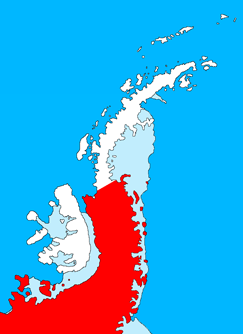
| Description |
English: Outline map of the Antarctic Peninsula showing
Palmer Land.
Drawn by me (User:Grutness) based on
File:Ant-pen_map.png by Giovanni Fattori. |
| Date | 2 July 2011 (original upload date) |
| Source | Transferred from en.wikipedia to Commons. |
| Author | The original uploader was Grutness at English Wikipedia. |
Licensing

|
Permission is granted to copy, distribute and/or modify this document under the terms of the GNU Free Documentation License, Version 1.2 or any later version published by the Free Software Foundation; with no Invariant Sections, no Front-Cover Texts, and no Back-Cover Texts. A copy of the license is included in the section entitled GNU Free Documentation License. |
Original upload log
The original description page was
here. All following user names refer to en.wikipedia.
- 2011-07-02 09:39 Grutness 243×334× (33143 bytes) Outline map of the Antarctic Peninsula showing [[Palmer Land]]. Drawn by me (User:Grutness) based on [[:File:Ant-pen_map.png]] by Giovanni Fattori.{{GFDL}}
File history
Click on a date/time to view the file as it appeared at that time.
| Date/Time | Thumbnail | Dimensions | User | Comment | |
|---|---|---|---|---|---|
| current | 20:09, 9 July 2011 |
| 243 × 334 (32 KB) | MGA73bot2 | {{BotMoveToCommons|en.wikipedia|year={{subst:CURRENTYEAR}}|month={{subst:CURRENTMONTHNAME}}|day={{subst:CURRENTDAY}}}} {{Information |Description={{en|Outline map of the Antarctic Peninsula showing en:Palmer Land. Drawn by me (User:Grutness) base |
File usage
More than 100 pages use this file. The following list shows the first 100 pages that use this file only. A full list is available.
- Airy Glacier
- Anchor Crag
- Arena Corner
- Armstrong Glacier
- Auriga Nunataks
- Bates Peak
- Batterbee Mountains
- Benson Hills
- Bergen Nunataks
- Berry Massif
- Bertram Glacier
- Bingham Glacier
- Black Coast
- Boreas Peak
- Braddock Nunataks
- Brennecke Nunataks
- Brindle Cliffs
- Bristly Peaks
- Brodie Peak
- Burkitt Nunatak
- Burns Bluff
- Bushell Bluff
- Campbell Ridges
- Canis Heights
- Canopus Crags
- Cape Byrd
- Cape Jeremy
- Capella Rocks
- Carse Point
- Cetus Hill
- Chapman Hump
- Cheesman Island
- Clifford Glacier
- Conchie Glacier
- Crescent Scarp
- Creswick Gap
- Creswick Peaks
- Croom Glacier
- DeAtley Island
- DeBusk Scarp
- Desko Mountains
- Dolleman Island
- Downs Nunatak
- Dyer Plateau
- Eklund Islands
- Elephant Ridge
- English Coast
- Enigma Peak
- Ethelbald Bluff
- Faure Islands
- George VI Ice Shelf
- Goward Peak
- Gurney Point
- Haag Nunataks
- Jaeger Hills
- Kubitza Glacier
- Morrill Peak
- Mount Allan (Antarctica)
- Mount Alpheratz
- Mount Castro
- Mount Courtauld
- Mount Crooker
- Mount Dixey
- Mount Eissinger
- Mount Pitman
- Mount Ward (Antarctica)
- Naess Glacier
- Niznik Island
- Norman Glacier
- Orion Massif
- Orville Coast
- Overton Peak
- Owen Peak
- Page Bluff
- Palmer Land
- Pampero Pass
- Pegasus Mountains
- Perseus Crags
- Powder Island
- Procyon Peaks
- Prospect Glacier
- Puppis Pikes
- Rothschild Island
- Shabica Glacier
- Simpson Hills
- Skytrain Ice Rise
- Smyley Island
- Thuma Peak
- Trost Rocks
- Utopia Glacier
- Wade Point
- Wagner Ice Piedmont
- Warren Ice Piedmont
- Webb Peak (Palmer Land)
- Wilkins Coast
- Willey Glacier
- Wordie Ice Shelf
- Wright Spires
- Zephyr Glacier
- Zonda Glacier
View more links to this file.
Global file usage
The following other wikis use this file:
- Usage on az.wikipedia.org
- Usage on de.wikipedia.org
- Usage on ru.wikipedia.org
- Usage on uk.wikipedia.org
- Usage on www.wikidata.org
- Usage on zh.wikipedia.org
No higher resolution available.
PalmerLandstubmap.png (243 × 334 pixels, file size: 32 KB, MIME type: image/png)
| This is a file from the
Wikimedia Commons. Information from its
description page there is shown below. Commons is a freely licensed media file repository. You can help. |
Summary
| Description |
English: Outline map of the Antarctic Peninsula showing
Palmer Land.
Drawn by me (User:Grutness) based on
File:Ant-pen_map.png by Giovanni Fattori. |
| Date | 2 July 2011 (original upload date) |
| Source | Transferred from en.wikipedia to Commons. |
| Author | The original uploader was Grutness at English Wikipedia. |
Licensing
|
|
Permission is granted to copy, distribute and/or modify this document under the terms of the GNU Free Documentation License, Version 1.2 or any later version published by the Free Software Foundation; with no Invariant Sections, no Front-Cover Texts, and no Back-Cover Texts. A copy of the license is included in the section entitled GNU Free Documentation License. |
Original upload log
The original description page was
here. All following user names refer to en.wikipedia.
- 2011-07-02 09:39 Grutness 243×334× (33143 bytes) Outline map of the Antarctic Peninsula showing [[Palmer Land]]. Drawn by me (User:Grutness) based on [[:File:Ant-pen_map.png]] by Giovanni Fattori.{{GFDL}}
File history
Click on a date/time to view the file as it appeared at that time.
| Date/Time | Thumbnail | Dimensions | User | Comment | |
|---|---|---|---|---|---|
| current | 20:09, 9 July 2011 |
| 243 × 334 (32 KB) | MGA73bot2 | {{BotMoveToCommons|en.wikipedia|year={{subst:CURRENTYEAR}}|month={{subst:CURRENTMONTHNAME}}|day={{subst:CURRENTDAY}}}} {{Information |Description={{en|Outline map of the Antarctic Peninsula showing en:Palmer Land. Drawn by me (User:Grutness) base |
File usage
More than 100 pages use this file. The following list shows the first 100 pages that use this file only. A full list is available.
- Airy Glacier
- Anchor Crag
- Arena Corner
- Armstrong Glacier
- Auriga Nunataks
- Bates Peak
- Batterbee Mountains
- Benson Hills
- Bergen Nunataks
- Berry Massif
- Bertram Glacier
- Bingham Glacier
- Black Coast
- Boreas Peak
- Braddock Nunataks
- Brennecke Nunataks
- Brindle Cliffs
- Bristly Peaks
- Brodie Peak
- Burkitt Nunatak
- Burns Bluff
- Bushell Bluff
- Campbell Ridges
- Canis Heights
- Canopus Crags
- Cape Byrd
- Cape Jeremy
- Capella Rocks
- Carse Point
- Cetus Hill
- Chapman Hump
- Cheesman Island
- Clifford Glacier
- Conchie Glacier
- Crescent Scarp
- Creswick Gap
- Creswick Peaks
- Croom Glacier
- DeAtley Island
- DeBusk Scarp
- Desko Mountains
- Dolleman Island
- Downs Nunatak
- Dyer Plateau
- Eklund Islands
- Elephant Ridge
- English Coast
- Enigma Peak
- Ethelbald Bluff
- Faure Islands
- George VI Ice Shelf
- Goward Peak
- Gurney Point
- Haag Nunataks
- Jaeger Hills
- Kubitza Glacier
- Morrill Peak
- Mount Allan (Antarctica)
- Mount Alpheratz
- Mount Castro
- Mount Courtauld
- Mount Crooker
- Mount Dixey
- Mount Eissinger
- Mount Pitman
- Mount Ward (Antarctica)
- Naess Glacier
- Niznik Island
- Norman Glacier
- Orion Massif
- Orville Coast
- Overton Peak
- Owen Peak
- Page Bluff
- Palmer Land
- Pampero Pass
- Pegasus Mountains
- Perseus Crags
- Powder Island
- Procyon Peaks
- Prospect Glacier
- Puppis Pikes
- Rothschild Island
- Shabica Glacier
- Simpson Hills
- Skytrain Ice Rise
- Smyley Island
- Thuma Peak
- Trost Rocks
- Utopia Glacier
- Wade Point
- Wagner Ice Piedmont
- Warren Ice Piedmont
- Webb Peak (Palmer Land)
- Wilkins Coast
- Willey Glacier
- Wordie Ice Shelf
- Wright Spires
- Zephyr Glacier
- Zonda Glacier
View more links to this file.
Global file usage
The following other wikis use this file:
- Usage on az.wikipedia.org
- Usage on de.wikipedia.org
- Usage on ru.wikipedia.org
- Usage on uk.wikipedia.org
- Usage on www.wikidata.org
- Usage on zh.wikipedia.org