No higher resolution available.
PN_-A.png (500 × 500 pixels, file size: 9 KB, MIME type: image/png)
| This is a file from the
Wikimedia Commons. Information from its
description page there is shown below. Commons is a freely licensed media file repository. You can help. |
Summary
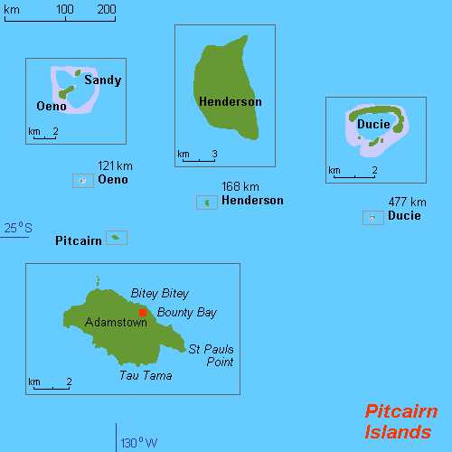
| Description |
English: Map of Pitcairn Islands (rough), Pacific Ocean, own work composed from various mapreferences |
| Date | |
| Source | Own work |
| Author | Hobe / Holger Behr |

|
This map image could be re-created using
vector graphics as an
SVG file. This has several advantages; see
Commons:Media for cleanup for more information. If an SVG form of this image is available, please upload it and afterwards replace this template with
{{
vector version available|new image name}}
.
It is recommended to name the SVG file “PN -A.svg”—then the template Vector version available (or Vva) does not need the new image name parameter. |
Licensing
I, the copyright holder of this work, hereby publish it under the following licenses:
This file is licensed under the
Creative Commons
Attribution-Share Alike 3.0 Unported license.
- You are free:
- to share – to copy, distribute and transmit the work
- to remix – to adapt the work
- Under the following conditions:
- attribution – You must give appropriate credit, provide a link to the license, and indicate if changes were made. You may do so in any reasonable manner, but not in any way that suggests the licensor endorses you or your use.
- share alike – If you remix, transform, or build upon the material, you must distribute your contributions under the same or compatible license as the original.

|
Permission is granted to copy, distribute and/or modify this document under the terms of the GNU Free Documentation License, Version 1.2 or any later version published by the Free Software Foundation; with no Invariant Sections, no Front-Cover Texts, and no Back-Cover Texts. A copy of the license is included in the section entitled GNU Free Documentation License. |
You may select the license of your choice.
File history
Click on a date/time to view the file as it appeared at that time.
| Date/Time | Thumbnail | Dimensions | User | Comment | |
|---|---|---|---|---|---|
| current | 20:22, 13 May 2012 |
| 500 × 500 (9 KB) | Túrelio | Reverted to version as of 15:10, 11 November 2010, as it is against our policy to overwrite existing images from other users. |
| 14:45, 6 May 2012 |
 | 1,378 × 845 (54 KB) | An678ko | everted to version as of 13:00, 6 May 2012; Pleasе, leave this map! stop modify and update them! Wikipedia is not fun! I added a beautiful card with a modern design! You also try to keep a map which resolution is 500 × 500px. Leave my map 936 × 5... | |
| 10:28, 6 May 2012 |
 | 500 × 500 (9 KB) | NordNordWest | Reverted to version as of 15:10, 11 November 2010; duplicate of File:Map of Pitcairn Islands.png | |
| 01:48, 6 May 2012 |
 | 936 × 503 (32 KB) | An678ko | redesigned by Aplusc Studio | |
| 15:10, 11 November 2010 |
 | 500 × 500 (9 KB) | Hobe | {{Information |Description={{en|1=Map of Pitcairn Islands (rough), Pacific Ocean, own work composed from various mapreferences}} |Source={{own}} |Author= Hobe / Holger Behr |Date=2010-04-25 |Permission= |other_versions= }} [[Category:Maps of |
File usage
The following pages on the English Wikipedia use this file (pages on other projects are not listed):
Global file usage
The following other wikis use this file:
- Usage on als.wikipedia.org
- Usage on br.wikipedia.org
- Usage on de.wikipedia.org
- Usage on eo.wikipedia.org
- Usage on fr.wikipedia.org
- Usage on hr.wikipedia.org
- Usage on it.wikipedia.org
- Usage on ja.wikipedia.org
- Usage on la.wikipedia.org
- Usage on li.wikipedia.org
- Usage on my.wikipedia.org
- Usage on nl.wikipedia.org
- Usage on no.wikipedia.org
- Usage on sv.wikipedia.org
- Usage on sv.wikivoyage.org
- Usage on ur.wikipedia.org
- Usage on vi.wikipedia.org
No higher resolution available.
PN_-A.png (500 × 500 pixels, file size: 9 KB, MIME type: image/png)
| This is a file from the
Wikimedia Commons. Information from its
description page there is shown below. Commons is a freely licensed media file repository. You can help. |
Summary
| Description |
English: Map of Pitcairn Islands (rough), Pacific Ocean, own work composed from various mapreferences |
| Date | |
| Source | Own work |
| Author | Hobe / Holger Behr |
|
|
This map image could be re-created using
vector graphics as an
SVG file. This has several advantages; see
Commons:Media for cleanup for more information. If an SVG form of this image is available, please upload it and afterwards replace this template with
{{
vector version available|new image name}}
.
It is recommended to name the SVG file “PN -A.svg”—then the template Vector version available (or Vva) does not need the new image name parameter. |
Licensing
I, the copyright holder of this work, hereby publish it under the following licenses:
This file is licensed under the
Creative Commons
Attribution-Share Alike 3.0 Unported license.
- You are free:
- to share – to copy, distribute and transmit the work
- to remix – to adapt the work
- Under the following conditions:
- attribution – You must give appropriate credit, provide a link to the license, and indicate if changes were made. You may do so in any reasonable manner, but not in any way that suggests the licensor endorses you or your use.
- share alike – If you remix, transform, or build upon the material, you must distribute your contributions under the same or compatible license as the original.
|
|
Permission is granted to copy, distribute and/or modify this document under the terms of the GNU Free Documentation License, Version 1.2 or any later version published by the Free Software Foundation; with no Invariant Sections, no Front-Cover Texts, and no Back-Cover Texts. A copy of the license is included in the section entitled GNU Free Documentation License. |
You may select the license of your choice.
File history
Click on a date/time to view the file as it appeared at that time.
| Date/Time | Thumbnail | Dimensions | User | Comment | |
|---|---|---|---|---|---|
| current | 20:22, 13 May 2012 |
| 500 × 500 (9 KB) | Túrelio | Reverted to version as of 15:10, 11 November 2010, as it is against our policy to overwrite existing images from other users. |
| 14:45, 6 May 2012 |
| 1,378 × 845 (54 KB) | An678ko | everted to version as of 13:00, 6 May 2012; Pleasе, leave this map! stop modify and update them! Wikipedia is not fun! I added a beautiful card with a modern design! You also try to keep a map which resolution is 500 × 500px. Leave my map 936 × 5... | |
| 10:28, 6 May 2012 |
| 500 × 500 (9 KB) | NordNordWest | Reverted to version as of 15:10, 11 November 2010; duplicate of File:Map of Pitcairn Islands.png | |
| 01:48, 6 May 2012 |
| 936 × 503 (32 KB) | An678ko | redesigned by Aplusc Studio | |
| 15:10, 11 November 2010 |
| 500 × 500 (9 KB) | Hobe | {{Information |Description={{en|1=Map of Pitcairn Islands (rough), Pacific Ocean, own work composed from various mapreferences}} |Source={{own}} |Author= Hobe / Holger Behr |Date=2010-04-25 |Permission= |other_versions= }} [[Category:Maps of |
File usage
The following pages on the English Wikipedia use this file (pages on other projects are not listed):
Global file usage
The following other wikis use this file:
- Usage on als.wikipedia.org
- Usage on br.wikipedia.org
- Usage on de.wikipedia.org
- Usage on eo.wikipedia.org
- Usage on fr.wikipedia.org
- Usage on hr.wikipedia.org
- Usage on it.wikipedia.org
- Usage on ja.wikipedia.org
- Usage on la.wikipedia.org
- Usage on li.wikipedia.org
- Usage on my.wikipedia.org
- Usage on nl.wikipedia.org
- Usage on no.wikipedia.org
- Usage on sv.wikipedia.org
- Usage on sv.wikivoyage.org
- Usage on ur.wikipedia.org
- Usage on vi.wikipedia.org