
Size of this PNG preview of this SVG file:
617 × 600 pixels. Other resolutions:
247 × 240 pixels |
494 × 480 pixels |
790 × 768 pixels |
1,053 × 1,024 pixels |
2,107 × 2,048 pixels |
863 × 839 pixels.
Original file (SVG file, nominally 863 × 839 pixels, file size: 509 KB)
| This is a file from the
Wikimedia Commons. Information from its
description page there is shown below. Commons is a freely licensed media file repository. You can help. |
Summary
| Description |
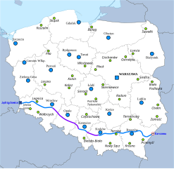
English: Map of route of
national road 4 in Poland.
Toll motorway A4
National road 4
Motorway under construction Former capital of former voivodeship
Capital of voivodeship Polski: Mapa przebiegu
drogi krajowej nr 4.
Płatna autostrada A4
Droga krajowa nr 4
Autostrada w budowie Dawne miasto wojewódzkie
Miasto wojewódzkie |
| Date | |
| Source | Own work |
| Author | Miko101 |
| Permission ( Reusing this file) |
This file is licensed under the
Creative Commons
Attribution-Share Alike 3.0 Unported license.
|
| Other versions | File:Mapa DK2.png |
additional info:
- File:EU-Icon.svg & File:BAB-Grenze.svg done by User:Qualle
- background: File:Poland location map white.svg done by User:Mareklug (license: cc-by-sa-3.0)
File history
Click on a date/time to view the file as it appeared at that time.
| Date/Time | Thumbnail | Dimensions | User | Comment | |
|---|---|---|---|---|---|
| current | 11:19, 21 July 2016 |
| 863 × 839 (509 KB) | Winnetou14 | a4 opened |
| 20:49, 2 September 2013 |
 | 863 × 839 (509 KB) | Miko101 | drobne korekty | |
| 22:25, 24 August 2013 |
 | 863 × 839 (490 KB) | Miko101 | zmiana wyglądu mapy, dodanie pozostałych byłych miast wojewódzkich oraz uaktualnienie przebiegu A4 i DK4 | |
| 23:17, 7 September 2012 |
 | 616 × 581 (571 KB) | Miko101 | update | |
| 04:38, 18 July 2011 |
 | 616 × 581 (255 KB) | Miko101 | {{Information |Description ={{en|1=Map of route of national road 4 in Poland. Map legend is available here.}} {{pl|1=Mapa przebiegu drogi krajowej nr 4. Legenda dostępna jest tutaj.} |
File usage
The following pages on the English Wikipedia use this file (pages on other projects are not listed):
Global file usage
The following other wikis use this file:
- Usage on eo.wikipedia.org
- Usage on it.wikipedia.org
- Usage on lmo.wikipedia.org
- Usage on nl.wikipedia.org
- Usage on pl.wikipedia.org
- Usage on sk.wikipedia.org
- Usage on uk.wikipedia.org
- Usage on vi.wikipedia.org
- Usage on www.wikidata.org
Metadata
Size of this PNG preview of this SVG file:
617 × 600 pixels. Other resolutions:
247 × 240 pixels |
494 × 480 pixels |
790 × 768 pixels |
1,053 × 1,024 pixels |
2,107 × 2,048 pixels |
863 × 839 pixels.
Original file (SVG file, nominally 863 × 839 pixels, file size: 509 KB)
| This is a file from the
Wikimedia Commons. Information from its
description page there is shown below. Commons is a freely licensed media file repository. You can help. |
Summary
| Description |
English: Map of route of
national road 4 in Poland.
Toll motorway A4
National road 4
Motorway under construction Former capital of former voivodeship
Capital of voivodeship Polski: Mapa przebiegu
drogi krajowej nr 4.
Płatna autostrada A4
Droga krajowa nr 4
Autostrada w budowie Dawne miasto wojewódzkie
Miasto wojewódzkie |
| Date | |
| Source | Own work |
| Author | Miko101 |
| Permission ( Reusing this file) |
This file is licensed under the
Creative Commons
Attribution-Share Alike 3.0 Unported license.
|
| Other versions | File:Mapa DK2.png |
additional info:
- File:EU-Icon.svg & File:BAB-Grenze.svg done by User:Qualle
- background: File:Poland location map white.svg done by User:Mareklug (license: cc-by-sa-3.0)
File history
Click on a date/time to view the file as it appeared at that time.
| Date/Time | Thumbnail | Dimensions | User | Comment | |
|---|---|---|---|---|---|
| current | 11:19, 21 July 2016 |
| 863 × 839 (509 KB) | Winnetou14 | a4 opened |
| 20:49, 2 September 2013 |
| 863 × 839 (509 KB) | Miko101 | drobne korekty | |
| 22:25, 24 August 2013 |
| 863 × 839 (490 KB) | Miko101 | zmiana wyglądu mapy, dodanie pozostałych byłych miast wojewódzkich oraz uaktualnienie przebiegu A4 i DK4 | |
| 23:17, 7 September 2012 |
| 616 × 581 (571 KB) | Miko101 | update | |
| 04:38, 18 July 2011 |
| 616 × 581 (255 KB) | Miko101 | {{Information |Description ={{en|1=Map of route of national road 4 in Poland. Map legend is available here.}} {{pl|1=Mapa przebiegu drogi krajowej nr 4. Legenda dostępna jest tutaj.} |
File usage
The following pages on the English Wikipedia use this file (pages on other projects are not listed):
Global file usage
The following other wikis use this file:
- Usage on eo.wikipedia.org
- Usage on it.wikipedia.org
- Usage on lmo.wikipedia.org
- Usage on nl.wikipedia.org
- Usage on pl.wikipedia.org
- Usage on sk.wikipedia.org
- Usage on uk.wikipedia.org
- Usage on vi.wikipedia.org
- Usage on www.wikidata.org