Size of this preview:
800 × 404 pixels. Other resolutions:
320 × 161 pixels |
640 × 323 pixels |
1,024 × 517 pixels |
1,280 × 646 pixels |
3,295 × 1,662 pixels.
Original file (3,295 × 1,662 pixels, file size: 1.76 MB, MIME type: image/jpeg)
| This is a file from the
Wikimedia Commons. Information from its
description page there is shown below. Commons is a freely licensed media file repository. You can help. |
Summary
| Description |
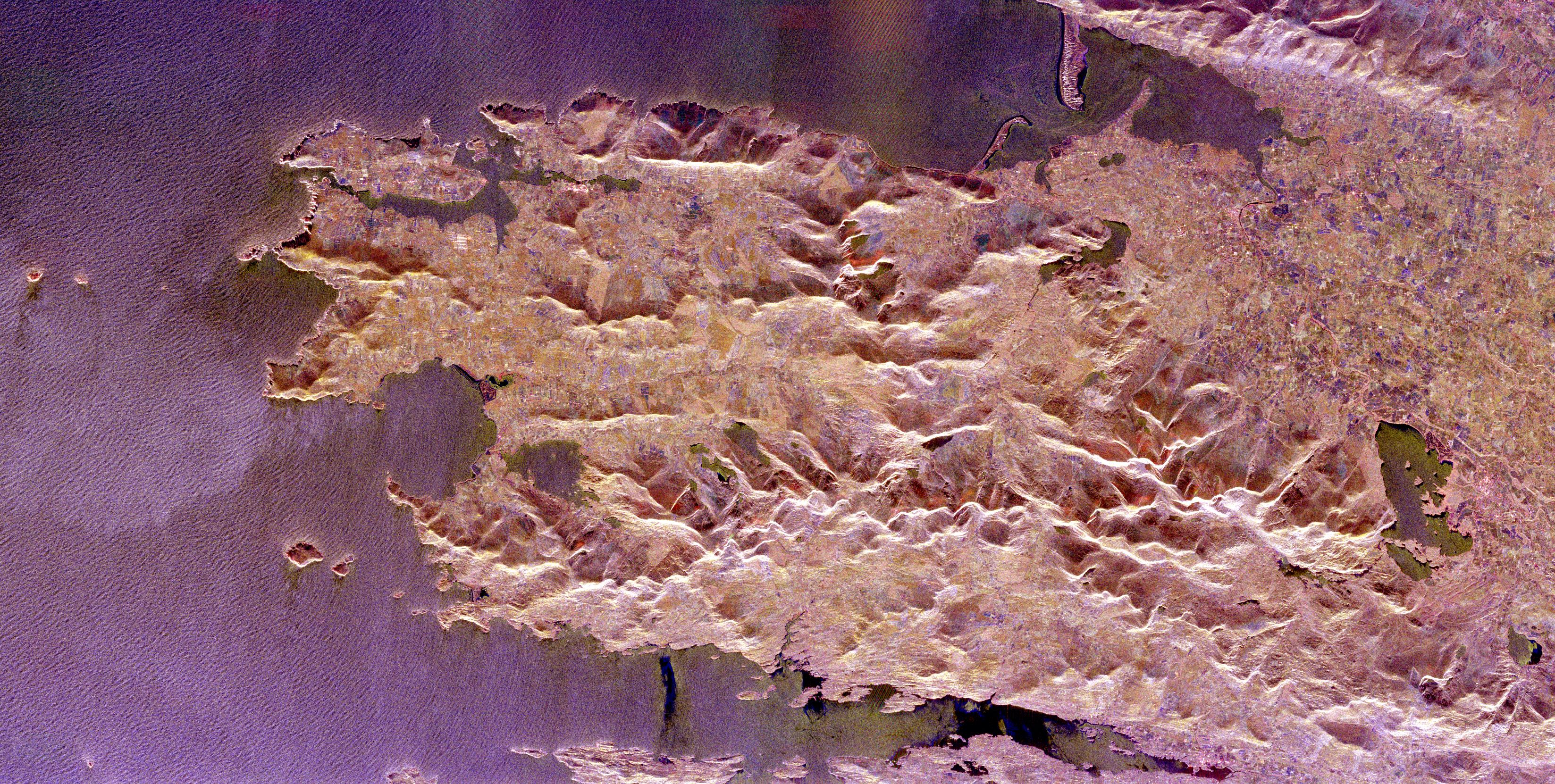
English: This image was acquired by the Spaceborne Imaging Radar-C/X-band Synthetic Aperture Radar (SIR-C/X-SAR) onboard the Space Shuttle Endeavour on April 12, 1994. The image is 82 kilometers by 42 kilometers (51 miles by 26 miles) and is centered at 52.0 degrees north latitude, 9.9 degrees west longitude. North is toward the lower left. The colors are assigned to different radar frequencies and polarizations of the radar as follows: red is L-band, horizontally transmitted and received; green is L-band, vertically transmitted and received; and blue is C-band, vertically transmitted and received. SIR-C/X-SAR, a joint mission of the German, Italian and United States space agencies, is part of NASA's Mission to Planet Earth program. |
| Source |
PIA01848: Space Radar Image of County Kerry, Ireland 18 mb tiff available at http://photojournal.jpl.nasa.gov/catalog/PIA01848 |
| Author |
Licensing
| This file is in the public domain in the United States because it was solely created by NASA. NASA copyright policy states that "NASA material is not protected by copyright unless noted". (See Template:PD-USGov, NASA copyright policy page or JPL Image Use Policy.) | ||
 |
Warnings:
|
Original upload log
Transferred from en.wikipedia to Commons using For the Common Good.
The original description page was
here. All following user names refer to en.wikipedia.
| Date/Time | Dimensions | User | Comment |
|---|---|---|---|
| 19:08, 16 April 2005 | 3,295 × 1,662 (1,841,132 bytes) | w:en:SeanMack ( talk | contribs) | PIA01848: Space Radar Image of County Kerry, Ireland 18 mb tiff avaialble at http://photojournal.jpl.nasa.gov/catalog/PIA01848 {{PD-USGov-NASA}} This image was acquired by the Spaceborne Imaging Radar-C/X-band Synthetic Aperture Radar (SIR-C/X-SAR) onboa |
File history
Click on a date/time to view the file as it appeared at that time.
| Date/Time | Thumbnail | Dimensions | User | Comment | |
|---|---|---|---|---|---|
| current | 03:06, 8 January 2018 |
| 3,295 × 1,662 (1.76 MB) | Illegitimate Barrister | Transferred from en.wikipedia: see original upload log above |
File usage
No pages on the English Wikipedia use this file (pages on other projects are not listed).
Size of this preview:
800 × 404 pixels. Other resolutions:
320 × 161 pixels |
640 × 323 pixels |
1,024 × 517 pixels |
1,280 × 646 pixels |
3,295 × 1,662 pixels.
Original file (3,295 × 1,662 pixels, file size: 1.76 MB, MIME type: image/jpeg)
| This is a file from the
Wikimedia Commons. Information from its
description page there is shown below. Commons is a freely licensed media file repository. You can help. |
Summary
| Description |
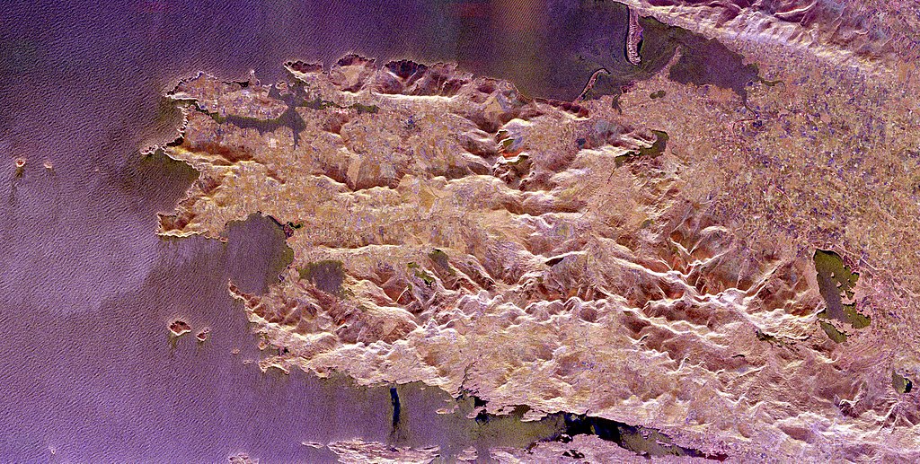
English: This image was acquired by the Spaceborne Imaging Radar-C/X-band Synthetic Aperture Radar (SIR-C/X-SAR) onboard the Space Shuttle Endeavour on April 12, 1994. The image is 82 kilometers by 42 kilometers (51 miles by 26 miles) and is centered at 52.0 degrees north latitude, 9.9 degrees west longitude. North is toward the lower left. The colors are assigned to different radar frequencies and polarizations of the radar as follows: red is L-band, horizontally transmitted and received; green is L-band, vertically transmitted and received; and blue is C-band, vertically transmitted and received. SIR-C/X-SAR, a joint mission of the German, Italian and United States space agencies, is part of NASA's Mission to Planet Earth program. |
| Source |
PIA01848: Space Radar Image of County Kerry, Ireland 18 mb tiff available at http://photojournal.jpl.nasa.gov/catalog/PIA01848 |
| Author |
Licensing
| This file is in the public domain in the United States because it was solely created by NASA. NASA copyright policy states that "NASA material is not protected by copyright unless noted". (See Template:PD-USGov, NASA copyright policy page or JPL Image Use Policy.) | ||
|
Warnings:
|
Original upload log
Transferred from en.wikipedia to Commons using For the Common Good.
The original description page was
here. All following user names refer to en.wikipedia.
| Date/Time | Dimensions | User | Comment |
|---|---|---|---|
| 19:08, 16 April 2005 | 3,295 × 1,662 (1,841,132 bytes) | w:en:SeanMack ( talk | contribs) | PIA01848: Space Radar Image of County Kerry, Ireland 18 mb tiff avaialble at http://photojournal.jpl.nasa.gov/catalog/PIA01848 {{PD-USGov-NASA}} This image was acquired by the Spaceborne Imaging Radar-C/X-band Synthetic Aperture Radar (SIR-C/X-SAR) onboa |
File history
Click on a date/time to view the file as it appeared at that time.
| Date/Time | Thumbnail | Dimensions | User | Comment | |
|---|---|---|---|---|---|
| current | 03:06, 8 January 2018 |
| 3,295 × 1,662 (1.76 MB) | Illegitimate Barrister | Transferred from en.wikipedia: see original upload log above |
File usage
No pages on the English Wikipedia use this file (pages on other projects are not listed).