
Original file (2,004 × 2,572 pixels, file size: 357 KB, MIME type: image/jpeg)
| This is a file from the
Wikimedia Commons. Information from its
description page there is shown below. Commons is a freely licensed media file repository. You can help. |
| Description |
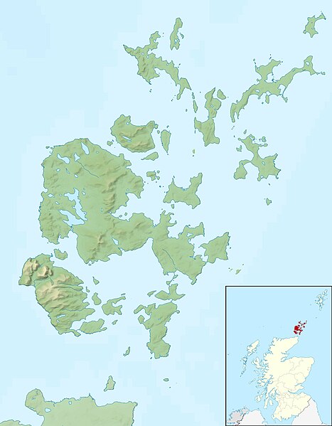
Relief map of the Orkney Islands (excluding Sule Stack and Sule Skerry), UK. Equirectangular map projection on WGS 84 datum, with N/S stretched 180% Geographic limits:
|
| Date | |
| Source |
|
| Author | Nilfanion, created using Ordnance Survey data |
| Permission ( Reusing this file) |
This file is licensed under the
Creative Commons
Attribution-Share Alike 3.0 Unported license. Attribution: Contains Ordnance Survey data © Crown copyright and database right
|
| Other versions | File:Orkney Islands UK blank map.svg - Blank map |
File history
Click on a date/time to view the file as it appeared at that time.
| Date/Time | Thumbnail | Dimensions | User | Comment | |
|---|---|---|---|---|---|
| current | 12:26, 30 November 2011 |
| 2,004 × 2,572 (357 KB) | Nilfanion | {{Information |Description=Relief map of the Orkney Islands (excluding Sule Stack and Sule Skerry), UK. Equirectangular map projection on WGS 84 datum, with N/S stretched 180% Geographic limits: *W |
File usage
- Auskerry
- Barrel of Butter
- Brough of Birsay
- Burray
- Calf of Eday
- Calf of Flotta
- Cava, Orkney
- Copinsay
- Damsay
- Eday
- Egilsay
- Eynhallow
- Fara, Orkney
- Faray
- Flotta
- Gairsay
- Glimps Holm
- Graemsay
- Helliar Holm
- Hoglinns Water
- Holm of Faray
- Holm of Grimbister
- Holm of Houton
- Holm of Huip
- Holm of Papa
- Holm of Scockness
- Horse of Copinsay
- Hoy, Orkney
- Hunda
- Inner Holm
- Kili Holm
- Lamb Holm
- Linga Holm
- Linga Sound, Orkney
- Loch of Boardhouse
- Loch of Bosquoy
- Loch of Harray
- Loch of Hundland
- Loch of Kirbister
- Loch of Skaill
- Loch of Stenness
- Loch of Swannay
- Loch of Tankerness
- Longhope Lifeboat Station
- Muckle Green Holm
- Muckle Water
- Nevi Skerry
- North Ronaldsay
- Old Man of Hoy
- Orkney
- Papa Stronsay
- Papa Westray
- Rousay
- Rusk Holm
- Rysa Little
- Sanday, Orkney
- Scapa Flow
- Shapinsay
- South Ronaldsay
- South Walls
- Stronsay
- Sweyn Holm
- Switha
- Swona
- Thieves Holm
- Vasa Loch
- Westray
- Wyre, Orkney
- User:Jokulhlaup/draftarticle21
- Template:Infobox Scottish island/testcases
- Module:Location map/data/Scotland Orkney
- Module:Location map/data/Scotland Orkney/doc
Global file usage
The following other wikis use this file:
- Usage on ar.wikipedia.org
- Usage on bg.wikipedia.org
- Usage on ceb.wikipedia.org
- Usage on de.wikipedia.org
- Scapa Flow
- Bootsgrab von Scar
- Inganess Bay
- Westray Stone
- Taversoe Tuick
- Yetnasteen
- Sule Stack
- Blackhammer
- Broch von Windwick
- Knowes o’ Trotty
- Damsay
- Wideford Hill Cairn
- Vorlage:Positionskarte Schottland Orkney
- Benutzer:Metilsteiner/KARTENDIENSTE
- Loch of Stenness
- Loch of Harray
- Souterrain von Windwick
- Ness of Brodgar
- Benutzer Diskussion:Thgoiter/Archiv/2013
- Gräberfeld von Westness
- Benutzer Diskussion:Metilsteiner/Archiv/2013/April
- Muckle Skerry (Orkney)
- Kili Holm
- Kirkwall Castle
- Menhire von Stanerandy
- Holm of Grimbister
- Usage on el.wikipedia.org
- Usage on eo.wikipedia.org
- Usage on es.wikipedia.org
View more global usage of this file.
Original file (2,004 × 2,572 pixels, file size: 357 KB, MIME type: image/jpeg)
| This is a file from the
Wikimedia Commons. Information from its
description page there is shown below. Commons is a freely licensed media file repository. You can help. |
| Description |
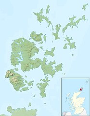
Relief map of the Orkney Islands (excluding Sule Stack and Sule Skerry), UK. Equirectangular map projection on WGS 84 datum, with N/S stretched 180% Geographic limits:
|
| Date | |
| Source |
|
| Author | Nilfanion, created using Ordnance Survey data |
| Permission ( Reusing this file) |
This file is licensed under the
Creative Commons
Attribution-Share Alike 3.0 Unported license. Attribution: Contains Ordnance Survey data © Crown copyright and database right
|
| Other versions | File:Orkney Islands UK blank map.svg - Blank map |
File history
Click on a date/time to view the file as it appeared at that time.
| Date/Time | Thumbnail | Dimensions | User | Comment | |
|---|---|---|---|---|---|
| current | 12:26, 30 November 2011 |
| 2,004 × 2,572 (357 KB) | Nilfanion | {{Information |Description=Relief map of the Orkney Islands (excluding Sule Stack and Sule Skerry), UK. Equirectangular map projection on WGS 84 datum, with N/S stretched 180% Geographic limits: *W |
File usage
- Auskerry
- Barrel of Butter
- Brough of Birsay
- Burray
- Calf of Eday
- Calf of Flotta
- Cava, Orkney
- Copinsay
- Damsay
- Eday
- Egilsay
- Eynhallow
- Fara, Orkney
- Faray
- Flotta
- Gairsay
- Glimps Holm
- Graemsay
- Helliar Holm
- Hoglinns Water
- Holm of Faray
- Holm of Grimbister
- Holm of Houton
- Holm of Huip
- Holm of Papa
- Holm of Scockness
- Horse of Copinsay
- Hoy, Orkney
- Hunda
- Inner Holm
- Kili Holm
- Lamb Holm
- Linga Holm
- Linga Sound, Orkney
- Loch of Boardhouse
- Loch of Bosquoy
- Loch of Harray
- Loch of Hundland
- Loch of Kirbister
- Loch of Skaill
- Loch of Stenness
- Loch of Swannay
- Loch of Tankerness
- Longhope Lifeboat Station
- Muckle Green Holm
- Muckle Water
- Nevi Skerry
- North Ronaldsay
- Old Man of Hoy
- Orkney
- Papa Stronsay
- Papa Westray
- Rousay
- Rusk Holm
- Rysa Little
- Sanday, Orkney
- Scapa Flow
- Shapinsay
- South Ronaldsay
- South Walls
- Stronsay
- Sweyn Holm
- Switha
- Swona
- Thieves Holm
- Vasa Loch
- Westray
- Wyre, Orkney
- User:Jokulhlaup/draftarticle21
- Template:Infobox Scottish island/testcases
- Module:Location map/data/Scotland Orkney
- Module:Location map/data/Scotland Orkney/doc
Global file usage
The following other wikis use this file:
- Usage on ar.wikipedia.org
- Usage on bg.wikipedia.org
- Usage on ceb.wikipedia.org
- Usage on de.wikipedia.org
- Scapa Flow
- Bootsgrab von Scar
- Inganess Bay
- Westray Stone
- Taversoe Tuick
- Yetnasteen
- Sule Stack
- Blackhammer
- Broch von Windwick
- Knowes o’ Trotty
- Damsay
- Wideford Hill Cairn
- Vorlage:Positionskarte Schottland Orkney
- Benutzer:Metilsteiner/KARTENDIENSTE
- Loch of Stenness
- Loch of Harray
- Souterrain von Windwick
- Ness of Brodgar
- Benutzer Diskussion:Thgoiter/Archiv/2013
- Gräberfeld von Westness
- Benutzer Diskussion:Metilsteiner/Archiv/2013/April
- Muckle Skerry (Orkney)
- Kili Holm
- Kirkwall Castle
- Menhire von Stanerandy
- Holm of Grimbister
- Usage on el.wikipedia.org
- Usage on eo.wikipedia.org
- Usage on es.wikipedia.org
View more global usage of this file.