No higher resolution available.
OldMapKent.jpg (410 × 324 pixels, file size: 90 KB, MIME type: image/jpeg)
| This is a file from the
Wikimedia Commons. Information from its
description page there is shown below. Commons is a freely licensed media file repository. You can help. |

|
File:KentAtTheComingOfTheSaxons.svg is a vector version of this file. It should be used in place of this JPG file when not inferior.
File:OldMapKent.jpg →
File:KentAtTheComingOfTheSaxons.svg
For more information, see
Help:SVG. |
 |
Summary
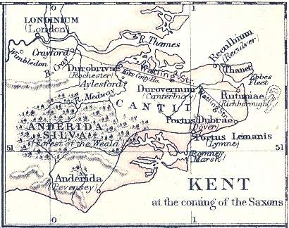
| Description | Map of "Kent at the coming of the Saxons" |
| Date | |
| Source | A School Atlas Of English History, Longmans, Green, 1892 |
| Author | S. R. Gardiner (d. 1902) |
Licensing
|
This work is in the public domain in its country of origin and other countries and areas where the copyright term is the author's life plus 100 years or fewer. | |
| This file has been identified as being free of known restrictions under copyright law, including all related and neighboring rights. | |
File history
Click on a date/time to view the file as it appeared at that time.
| Date/Time | Thumbnail | Dimensions | User | Comment | |
|---|---|---|---|---|---|
| current | 21:20, 6 June 2008 |
| 410 × 324 (90 KB) | Nortonius | {{Information |Description=Map of "Kent at the coming of the Saxons" |Source=''A School Atlas Of English History'' |Date=1892 |Author=S. R. Gardiner |Permission= |other_versions= }} |
File usage
The following pages on the English Wikipedia use this file (pages on other projects are not listed):
Global file usage
The following other wikis use this file:
- Usage on azb.wikipedia.org
- Usage on br.wikipedia.org
- Usage on ca.wikipedia.org
- Usage on cs.wikipedia.org
- Usage on de.wikipedia.org
- Usage on eo.wikipedia.org
- Usage on fr.wikipedia.org
- Usage on it.wikipedia.org
- Usage on nl.wikipedia.org
- Usage on no.wikipedia.org
- Usage on sk.wikipedia.org
- Usage on www.wikidata.org
Metadata
No higher resolution available.
OldMapKent.jpg (410 × 324 pixels, file size: 90 KB, MIME type: image/jpeg)
| This is a file from the
Wikimedia Commons. Information from its
description page there is shown below. Commons is a freely licensed media file repository. You can help. |
|
|
File:KentAtTheComingOfTheSaxons.svg is a vector version of this file. It should be used in place of this JPG file when not inferior.
File:OldMapKent.jpg →
File:KentAtTheComingOfTheSaxons.svg
For more information, see
Help:SVG. |
|
Summary
| Description | Map of "Kent at the coming of the Saxons" |
| Date | |
| Source | A School Atlas Of English History, Longmans, Green, 1892 |
| Author | S. R. Gardiner (d. 1902) |
Licensing
|
This work is in the public domain in its country of origin and other countries and areas where the copyright term is the author's life plus 100 years or fewer. | |
| This file has been identified as being free of known restrictions under copyright law, including all related and neighboring rights. | |
File history
Click on a date/time to view the file as it appeared at that time.
| Date/Time | Thumbnail | Dimensions | User | Comment | |
|---|---|---|---|---|---|
| current | 21:20, 6 June 2008 |
| 410 × 324 (90 KB) | Nortonius | {{Information |Description=Map of "Kent at the coming of the Saxons" |Source=''A School Atlas Of English History'' |Date=1892 |Author=S. R. Gardiner |Permission= |other_versions= }} |
File usage
The following pages on the English Wikipedia use this file (pages on other projects are not listed):
Global file usage
The following other wikis use this file:
- Usage on azb.wikipedia.org
- Usage on br.wikipedia.org
- Usage on ca.wikipedia.org
- Usage on cs.wikipedia.org
- Usage on de.wikipedia.org
- Usage on eo.wikipedia.org
- Usage on fr.wikipedia.org
- Usage on it.wikipedia.org
- Usage on nl.wikipedia.org
- Usage on no.wikipedia.org
- Usage on sk.wikipedia.org
- Usage on www.wikidata.org