Size of this preview:
800 × 474 pixels. Other resolutions:
320 × 190 pixels |
640 × 379 pixels |
1,024 × 607 pixels |
1,712 × 1,015 pixels.
Original file (1,712 × 1,015 pixels, file size: 532 KB, MIME type: image/png)
| This is a file from the
Wikimedia Commons. Information from its
description page there is shown below. Commons is a freely licensed media file repository. You can help. |
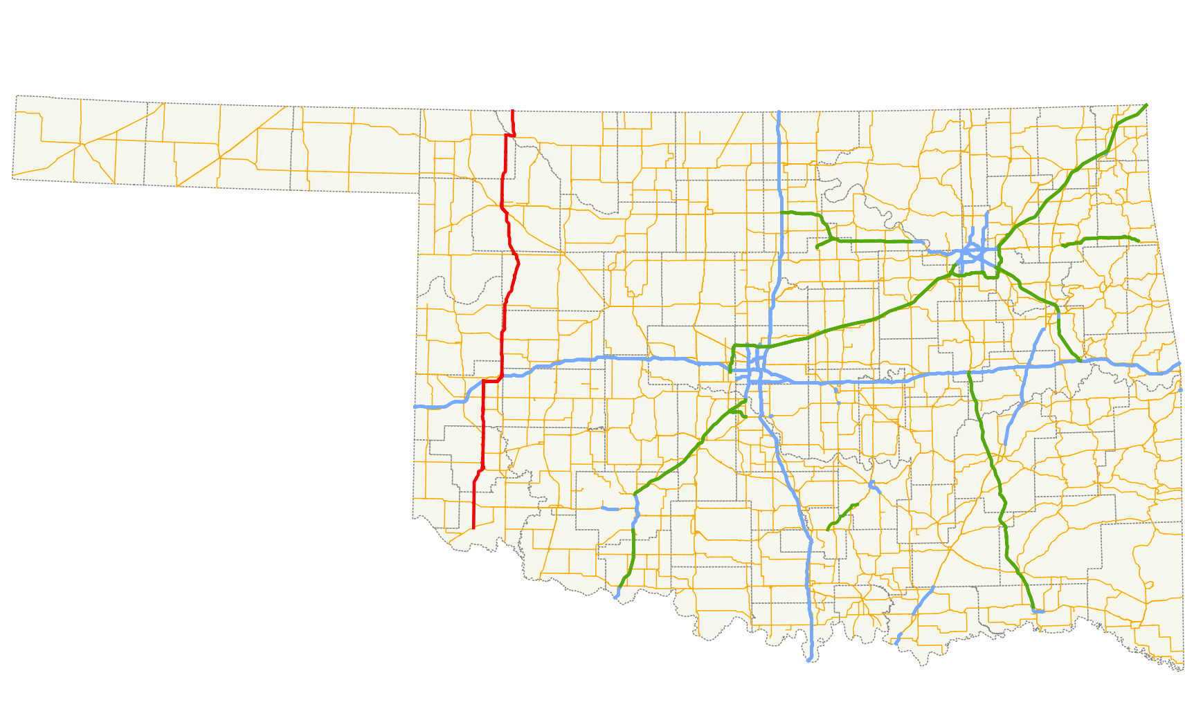
| Description | A map showing the path of State Highway 34 in Oklahoma. |
| Date | |
| Source |
Created by me in Quantum GIS 1.3.0 based on data collected from http://www.odot.org |
| Author | Scott Nazelrod |
| Permission ( Reusing this file) |
Public domain, credit appreciated but not required |
Legend
| Roads | Borders | ||||||||||||||
|---|---|---|---|---|---|---|---|---|---|---|---|---|---|---|---|
|
|
Licensing
| I, the copyright holder of this work, release this work into the
public domain. This applies worldwide. In some countries this may not be legally possible; if so: I grant anyone the right to use this work for any purpose, without any conditions, unless such conditions are required by law. |
File history
Click on a date/time to view the file as it appeared at that time.
| Date/Time | Thumbnail | Dimensions | User | Comment | |
|---|---|---|---|---|---|
| current | 17:51, 16 April 2010 |
| 1,712 × 1,015 (532 KB) | Scott5114 | {{Information |Description=A map showing the path of State Highway 34 in Oklahoma. |Source=Created by me in Quantum GIS 1.3.0 based on data collected from http://www.odot.org {{QGIS}} |Date=2010-04-16 |Author=[[User:Scott5 |
File usage
The following pages on the English Wikipedia use this file (pages on other projects are not listed):
Global file usage
The following other wikis use this file:
- Usage on www.wikidata.org
Size of this preview:
800 × 474 pixels. Other resolutions:
320 × 190 pixels |
640 × 379 pixels |
1,024 × 607 pixels |
1,712 × 1,015 pixels.
Original file (1,712 × 1,015 pixels, file size: 532 KB, MIME type: image/png)
| This is a file from the
Wikimedia Commons. Information from its
description page there is shown below. Commons is a freely licensed media file repository. You can help. |
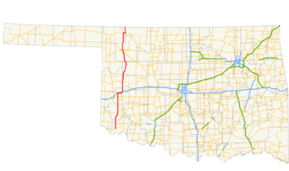
| Description | A map showing the path of State Highway 34 in Oklahoma. |
| Date | |
| Source |
Created by me in Quantum GIS 1.3.0 based on data collected from http://www.odot.org |
| Author | Scott Nazelrod |
| Permission ( Reusing this file) |
Public domain, credit appreciated but not required |
Legend
| Roads | Borders | ||||||||||||||
|---|---|---|---|---|---|---|---|---|---|---|---|---|---|---|---|
|
|
Licensing
| I, the copyright holder of this work, release this work into the
public domain. This applies worldwide. In some countries this may not be legally possible; if so: I grant anyone the right to use this work for any purpose, without any conditions, unless such conditions are required by law. |
File history
Click on a date/time to view the file as it appeared at that time.
| Date/Time | Thumbnail | Dimensions | User | Comment | |
|---|---|---|---|---|---|
| current | 17:51, 16 April 2010 |
| 1,712 × 1,015 (532 KB) | Scott5114 | {{Information |Description=A map showing the path of State Highway 34 in Oklahoma. |Source=Created by me in Quantum GIS 1.3.0 based on data collected from http://www.odot.org {{QGIS}} |Date=2010-04-16 |Author=[[User:Scott5 |
File usage
The following pages on the English Wikipedia use this file (pages on other projects are not listed):
Global file usage
The following other wikis use this file:
- Usage on www.wikidata.org