Size of this preview:
674 × 599 pixels. Other resolutions:
270 × 240 pixels |
540 × 480 pixels |
785 × 698 pixels.
Original file (785 × 698 pixels, file size: 102 KB, MIME type: image/jpeg)
| This is a file from the
Wikimedia Commons. Information from its
description page there is shown below. Commons is a freely licensed media file repository. You can help. |

|
This historical map image could be re-created using
vector graphics as an
SVG file. This has several advantages; see
Commons:Media for cleanup for more information. If an SVG form of this image is available, please upload it and afterwards replace this template with
{{
vector version available|new image name}}
.
It is recommended to name the SVG file “Oder-Neisse line between Germany and Poland.svg”—then the template Vector version available (or Vva) does not need the new image name parameter. |


Summary
| Description |
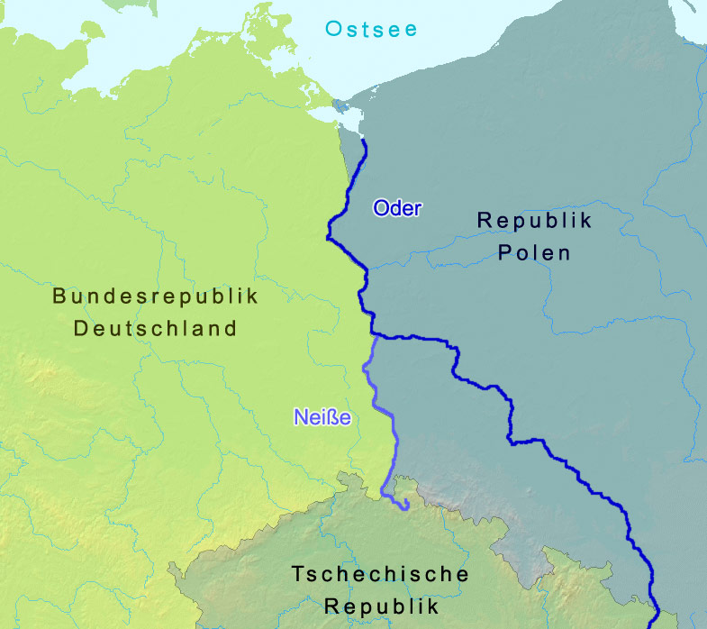
English: The named rivers are the border of Germany and Poland: the
Oder-Neisse line, save at the north end it is shifted slightly west to include the Polish city Szczecin and Polish-speaking villages. The countries are named in German. Czechia in its national tongue is Česko. Poland, in its, is Polska. The Baltic Sea is, in Polish,
morze Bałtyckie.
Deutsch: Grenze zwischen Polen und Deutschland entlang der
Oder-Neiße-Grenze |
| Date | |
| Source | A map from demis.nl |
| Author | Christoph Lingg |
| Permission ( Reusing this file) |
cc-by-sa-2.0-de |
| Uploaded at de.Wikipedia | 21 March 2006 12:55 |
| Uploaded at Commons | 15 May 2006 15:18 (UTC) |
Licensing
This file is licensed under the
Creative Commons
Attribution-Share Alike 2.0 Germany license.
- You are free:
- to share – to copy, distribute and transmit the work
- to remix – to adapt the work
- Under the following conditions:
- attribution – You must give appropriate credit, provide a link to the license, and indicate if changes were made. You may do so in any reasonable manner, but not in any way that suggests the licensor endorses you or your use.
- share alike – If you remix, transform, or build upon the material, you must distribute your contributions under the same or compatible license as the original.

Original upload log
Image history of de:Bild:Oder neisse grenze.jpg:
| Upload date | User | Bytes | Dimensions | Comment |
|---|---|---|---|---|
| 2006-03-21 17:57 | C.lingg | 104,398 | 785×698 | * Bildbeschreibung: Grenzverlauf zwischen Deutschland und Polen in Bezug auf die Oder-Neiße-Grenze * Quelle: Landkarte: demis.nl * Fotograf/Zeichner: Christoph Lingg * Datum: 22.03.2006 * Version: 2, Kontrast der Färbung von Dtl und Polen verstärkt |
| 2006-03-21 12:55 | C.lingg | 112,647 | 785×698 | * Bildbeschreibung: Grenzverlauf zwischen Deutschland und Polen in Bezug auf die Oder-Neiße-Grenze * Quelle: Landkarte: demis.nl * Fotograf/Zeichner: Christoph Lingg * Datum: 22.03.2006 |
File history
Click on a date/time to view the file as it appeared at that time.
| Date/Time | Thumbnail | Dimensions | User | Comment | |
|---|---|---|---|---|---|
| current | 15:19, 15 June 2006 |
| 785 × 698 (102 KB) | Thuresson | more contrast |
| 15:18, 15 June 2006 |
 | 785 × 698 (110 KB) | Thuresson |
File usage
The following pages on the English Wikipedia use this file (pages on other projects are not listed):
Global file usage
The following other wikis use this file:
- Usage on ar.wikipedia.org
- Usage on arz.wikipedia.org
- Usage on azb.wikipedia.org
- Usage on az.wikipedia.org
- Usage on be.wikipedia.org
- Usage on br.wikipedia.org
- Usage on ca.wikipedia.org
- Usage on cs.wikipedia.org
- Usage on cy.wikipedia.org
- Usage on da.wikipedia.org
- Usage on de.wikipedia.org
- Usage on dsb.wikipedia.org
- Usage on el.wikipedia.org
- Usage on eo.wikipedia.org
- Usage on es.wikipedia.org
- Usage on es.wikibooks.org
- Usage on eu.wikipedia.org
- Usage on fa.wikipedia.org
- Usage on fi.wikipedia.org
- Usage on fr.wikipedia.org
- Usage on fy.wikipedia.org
- Usage on ga.wikipedia.org
- Usage on gl.wikipedia.org
- Usage on he.wikipedia.org
- Usage on hr.wikipedia.org
- Usage on id.wikipedia.org
- Usage on incubator.wikimedia.org
- Usage on it.wikipedia.org
View more global usage of this file.
Metadata
Size of this preview:
674 × 599 pixels. Other resolutions:
270 × 240 pixels |
540 × 480 pixels |
785 × 698 pixels.
Original file (785 × 698 pixels, file size: 102 KB, MIME type: image/jpeg)
| This is a file from the
Wikimedia Commons. Information from its
description page there is shown below. Commons is a freely licensed media file repository. You can help. |
|
|
This historical map image could be re-created using
vector graphics as an
SVG file. This has several advantages; see
Commons:Media for cleanup for more information. If an SVG form of this image is available, please upload it and afterwards replace this template with
{{
vector version available|new image name}}
.
It is recommended to name the SVG file “Oder-Neisse line between Germany and Poland.svg”—then the template Vector version available (or Vva) does not need the new image name parameter. |
Summary
| Description |
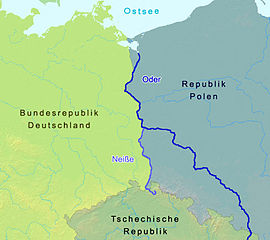
English: The named rivers are the border of Germany and Poland: the
Oder-Neisse line, save at the north end it is shifted slightly west to include the Polish city Szczecin and Polish-speaking villages. The countries are named in German. Czechia in its national tongue is Česko. Poland, in its, is Polska. The Baltic Sea is, in Polish,
morze Bałtyckie.
Deutsch: Grenze zwischen Polen und Deutschland entlang der
Oder-Neiße-Grenze |
| Date | |
| Source | A map from demis.nl |
| Author | Christoph Lingg |
| Permission ( Reusing this file) |
cc-by-sa-2.0-de |
| Uploaded at de.Wikipedia | 21 March 2006 12:55 |
| Uploaded at Commons | 15 May 2006 15:18 (UTC) |
Licensing
This file is licensed under the
Creative Commons
Attribution-Share Alike 2.0 Germany license.
- You are free:
- to share – to copy, distribute and transmit the work
- to remix – to adapt the work
- Under the following conditions:
- attribution – You must give appropriate credit, provide a link to the license, and indicate if changes were made. You may do so in any reasonable manner, but not in any way that suggests the licensor endorses you or your use.
- share alike – If you remix, transform, or build upon the material, you must distribute your contributions under the same or compatible license as the original.
Original upload log
Image history of de:Bild:Oder neisse grenze.jpg:
| Upload date | User | Bytes | Dimensions | Comment |
|---|---|---|---|---|
| 2006-03-21 17:57 | C.lingg | 104,398 | 785×698 | * Bildbeschreibung: Grenzverlauf zwischen Deutschland und Polen in Bezug auf die Oder-Neiße-Grenze * Quelle: Landkarte: demis.nl * Fotograf/Zeichner: Christoph Lingg * Datum: 22.03.2006 * Version: 2, Kontrast der Färbung von Dtl und Polen verstärkt |
| 2006-03-21 12:55 | C.lingg | 112,647 | 785×698 | * Bildbeschreibung: Grenzverlauf zwischen Deutschland und Polen in Bezug auf die Oder-Neiße-Grenze * Quelle: Landkarte: demis.nl * Fotograf/Zeichner: Christoph Lingg * Datum: 22.03.2006 |
File history
Click on a date/time to view the file as it appeared at that time.
| Date/Time | Thumbnail | Dimensions | User | Comment | |
|---|---|---|---|---|---|
| current | 15:19, 15 June 2006 |
| 785 × 698 (102 KB) | Thuresson | more contrast |
| 15:18, 15 June 2006 |
| 785 × 698 (110 KB) | Thuresson |
File usage
The following pages on the English Wikipedia use this file (pages on other projects are not listed):
Global file usage
The following other wikis use this file:
- Usage on ar.wikipedia.org
- Usage on arz.wikipedia.org
- Usage on azb.wikipedia.org
- Usage on az.wikipedia.org
- Usage on be.wikipedia.org
- Usage on br.wikipedia.org
- Usage on ca.wikipedia.org
- Usage on cs.wikipedia.org
- Usage on cy.wikipedia.org
- Usage on da.wikipedia.org
- Usage on de.wikipedia.org
- Usage on dsb.wikipedia.org
- Usage on el.wikipedia.org
- Usage on eo.wikipedia.org
- Usage on es.wikipedia.org
- Usage on es.wikibooks.org
- Usage on eu.wikipedia.org
- Usage on fa.wikipedia.org
- Usage on fi.wikipedia.org
- Usage on fr.wikipedia.org
- Usage on fy.wikipedia.org
- Usage on ga.wikipedia.org
- Usage on gl.wikipedia.org
- Usage on he.wikipedia.org
- Usage on hr.wikipedia.org
- Usage on id.wikipedia.org
- Usage on incubator.wikimedia.org
- Usage on it.wikipedia.org
View more global usage of this file.