No higher resolution available.
Noaa-outbreak-graphic.png (765 × 511 pixels, file size: 56 KB, MIME type: image/png)
| This is a file from the
Wikimedia Commons. Information from its
description page there is shown below. Commons is a freely licensed media file repository. You can help. |
Summary
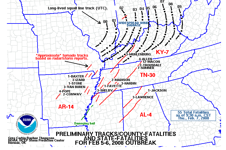
| Description | The Storm Prediction Center's preliminary tornado track map for February 5, 2008, the date of the Super Tuesday Tornado Outbreak of 2008. Map shows suspected tornado tracks and squall line movement. |
| Source | NOAA Storm Prediction Center |
| Author |
Licensing
This image is in the
public domain because it contains materials that originally came from the U.S.
National Oceanic and Atmospheric Administration, taken or made as part of an employee's official duties.
|
File history
Click on a date/time to view the file as it appeared at that time.
| Date/Time | Thumbnail | Dimensions | User | Comment | |
|---|---|---|---|---|---|
| current | 02:54, 8 February 2008 |
| 765 × 511 (56 KB) | USRoute66 | {{Information |Description= The Storm Prediction Center's preliminary tornado track map for February 5, 2008, the date of the Super Tuesday Tornado Outbreak of 2008. Map shows suspected tornado tracks and squall line movement. |Source= |
File usage
The following pages on the English Wikipedia use this file (pages on other projects are not listed):
Global file usage
The following other wikis use this file:
- Usage on ja.wikipedia.org
No higher resolution available.
Noaa-outbreak-graphic.png (765 × 511 pixels, file size: 56 KB, MIME type: image/png)
| This is a file from the
Wikimedia Commons. Information from its
description page there is shown below. Commons is a freely licensed media file repository. You can help. |
Summary
| Description | The Storm Prediction Center's preliminary tornado track map for February 5, 2008, the date of the Super Tuesday Tornado Outbreak of 2008. Map shows suspected tornado tracks and squall line movement. |
| Source | NOAA Storm Prediction Center |
| Author |
Licensing
This image is in the
public domain because it contains materials that originally came from the U.S.
National Oceanic and Atmospheric Administration, taken or made as part of an employee's official duties.
|
File history
Click on a date/time to view the file as it appeared at that time.
| Date/Time | Thumbnail | Dimensions | User | Comment | |
|---|---|---|---|---|---|
| current | 02:54, 8 February 2008 |
| 765 × 511 (56 KB) | USRoute66 | {{Information |Description= The Storm Prediction Center's preliminary tornado track map for February 5, 2008, the date of the Super Tuesday Tornado Outbreak of 2008. Map shows suspected tornado tracks and squall line movement. |Source= |
File usage
The following pages on the English Wikipedia use this file (pages on other projects are not listed):
Global file usage
The following other wikis use this file:
- Usage on ja.wikipedia.org