Photos • Location


Size of this preview:
635 × 599 pixels. Other resolutions:
254 × 240 pixels |
509 × 480 pixels |
640 × 604 pixels.
Original file (640 × 604 pixels, file size: 132 KB, MIME type: image/jpeg)
| This is a file from the
Wikimedia Commons. Information from its
description page there is shown below. Commons is a freely licensed media file repository. You can help. |
Summary
| Description |
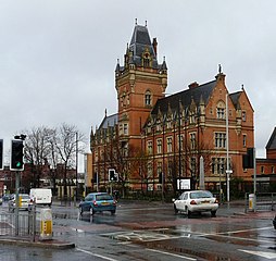
English: Nicholls Hospital Nicholls Hospital was founded in memory of John Ashton Nicholls (son of cotton merchant Benjamin Nicholls) who died aged only 36 (1823-1859). It was completed in 1881 and served as a school for poor boys of the area. During WWII it was used as a barracks. In 1953 it became Nicholls County Secondary School for Boys and later became part of Ellen Wilkinson High School. Now known as Nicholls House, in 2002 it became part of Manchester College.
http://www.mancat.ac.uk/aboutus/History/nicholls.htm |
| Date | |
| Source | From geograph.org.uk |
| Author | Gerald England |
| Attribution ( required by the license) | Gerald England / Nicholls Hospital / |
| Camera location | | View this and other nearby images on: OpenStreetMap |
|
|---|
_heading:337.00&language=en)
| Object location | | View this and other nearby images on: OpenStreetMap |
|
|---|
_heading:337.00&language=en)
Licensing

|
This image was taken from the
Geograph project collection. See
this photograph's page on the Geograph website for the photographer's contact details. The copyright on this image is owned by Gerald England and is licensed for reuse under the
Creative Commons Attribution-ShareAlike 2.0 license.
|
This file is licensed under the
Creative Commons
Attribution-Share Alike 2.0 Generic license.
Attribution: Gerald England
- You are free:
- to share – to copy, distribute and transmit the work
- to remix – to adapt the work
- Under the following conditions:
- attribution – You must give appropriate credit, provide a link to the license, and indicate if changes were made. You may do so in any reasonable manner, but not in any way that suggests the licensor endorses you or your use.
- share alike – If you remix, transform, or build upon the material, you must distribute your contributions under the same or compatible license as the original.
File history
Click on a date/time to view the file as it appeared at that time.
| Date/Time | Thumbnail | Dimensions | User | Comment | |
|---|---|---|---|---|---|
| current | 10:26, 26 February 2011 |
| 640 × 604 (132 KB) | GeographBot | == {{int:filedesc}} == {{Information |description={{en|1=Nicholls Hospital Nicholls Hospital was founded by the cotton merchant John Nicholls who died aged only 36 (1823-1859). It was completed in 1881 and served as a school for poor boys of the area. Dur |
File usage
The following pages on the English Wikipedia use this file (pages on other projects are not listed):
Global file usage
The following other wikis use this file:
- Usage on dag.wikipedia.org
- Usage on hy.wikipedia.org
- Usage on pl.wikipedia.org
- Usage on pt.wikipedia.org
- Usage on ru.wikipedia.org
- Usage on www.wikidata.org
Metadata
Size of this preview:
635 × 599 pixels. Other resolutions:
254 × 240 pixels |
509 × 480 pixels |
640 × 604 pixels.
Original file (640 × 604 pixels, file size: 132 KB, MIME type: image/jpeg)
| This is a file from the
Wikimedia Commons. Information from its
description page there is shown below. Commons is a freely licensed media file repository. You can help. |
Summary
| Description |
English: Nicholls Hospital Nicholls Hospital was founded in memory of John Ashton Nicholls (son of cotton merchant Benjamin Nicholls) who died aged only 36 (1823-1859). It was completed in 1881 and served as a school for poor boys of the area. During WWII it was used as a barracks. In 1953 it became Nicholls County Secondary School for Boys and later became part of Ellen Wilkinson High School. Now known as Nicholls House, in 2002 it became part of Manchester College.
http://www.mancat.ac.uk/aboutus/History/nicholls.htm |
| Date | |
| Source | From geograph.org.uk |
| Author | Gerald England |
| Attribution ( required by the license) | Gerald England / Nicholls Hospital / |
| Camera location | | View this and other nearby images on: OpenStreetMap |
|
|---|
| Object location | | View this and other nearby images on: OpenStreetMap |
|
|---|
Licensing
|
|
This image was taken from the
Geograph project collection. See
this photograph's page on the Geograph website for the photographer's contact details. The copyright on this image is owned by Gerald England and is licensed for reuse under the
Creative Commons Attribution-ShareAlike 2.0 license.
|
This file is licensed under the
Creative Commons
Attribution-Share Alike 2.0 Generic license.
Attribution: Gerald England
- You are free:
- to share – to copy, distribute and transmit the work
- to remix – to adapt the work
- Under the following conditions:
- attribution – You must give appropriate credit, provide a link to the license, and indicate if changes were made. You may do so in any reasonable manner, but not in any way that suggests the licensor endorses you or your use.
- share alike – If you remix, transform, or build upon the material, you must distribute your contributions under the same or compatible license as the original.
File history
Click on a date/time to view the file as it appeared at that time.
| Date/Time | Thumbnail | Dimensions | User | Comment | |
|---|---|---|---|---|---|
| current | 10:26, 26 February 2011 |
| 640 × 604 (132 KB) | GeographBot | == {{int:filedesc}} == {{Information |description={{en|1=Nicholls Hospital Nicholls Hospital was founded by the cotton merchant John Nicholls who died aged only 36 (1823-1859). It was completed in 1881 and served as a school for poor boys of the area. Dur |
File usage
The following pages on the English Wikipedia use this file (pages on other projects are not listed):
Global file usage
The following other wikis use this file:
- Usage on dag.wikipedia.org
- Usage on hy.wikipedia.org
- Usage on pl.wikipedia.org
- Usage on pt.wikipedia.org
- Usage on ru.wikipedia.org
- Usage on www.wikidata.org