
Size of this preview:
298 × 598 pixels. Other resolutions:
119 × 240 pixels |
540 × 1,084 pixels.
Original file (540 × 1,084 pixels, file size: 149 KB, MIME type: image/jpeg)
| This is a file from the
Wikimedia Commons. Information from its
description page there is shown below. Commons is a freely licensed media file repository. You can help. |
Summary
| Description |
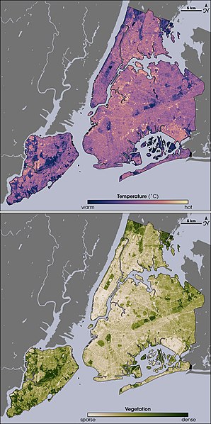
English: Thermal infrared satellite data measured by NASAâs Landsat Enhanced Thematic Mapper Plus on August 14, 2002 one of the hottest days in New York City's summer. Landsat also collected vegetation data. Image from NASA EArth Observatory web page <
http://earthobservatory.nasa.gov/Newsroom/NewImages/images.php3?img_id=17354> --
Ryanjo 23:43, 1 August 2006 (UTC) |
| Source | NASA |
| Author | |
| Other versions |
 |
Licensing
| This file is in the public domain in the United States because it was solely created by NASA. NASA copyright policy states that "NASA material is not protected by copyright unless noted". (See Template:PD-USGov, NASA copyright policy page or JPL Image Use Policy.) | ||
 |
Warnings:
|
Original upload log
The original description page was
here. All following user names refer to en.wikipedia.
- 2006-08-01 23:43 Ryanjo 540×1084× (152802 bytes) Thermal infrared satellite data measured by NASAâs Landsat Enhanced Thematic Mapper Plus on August 14, 2002 one of the hottest days in New York City's summer. Landsat also collected vegetation data. Image from NASA EArth Observatory web page <http://ear
File history
Click on a date/time to view the file as it appeared at that time.
| Date/Time | Thumbnail | Dimensions | User | Comment | |
|---|---|---|---|---|---|
| current | 14:49, 23 February 2009 |
| 540 × 1,084 (149 KB) | File Upload Bot (Magnus Manske) | {{BotMoveToCommons|en.wikipedia|year={{subst:CURRENTYEAR}}|month={{subst:CURRENTMONTHNAME}}|day={{subst:CURRENTDAY}}}} {{Information |Description={{en|Thermal infrared satellite data measured by NASAâs Landsat Enhanced Thematic Mapper Plus on August |
File usage
The following pages on the English Wikipedia use this file (pages on other projects are not listed):
Global file usage
The following other wikis use this file:
- Usage on af.wikipedia.org
- Usage on ca.wikipedia.org
- Usage on da.wikipedia.org
- Usage on eo.wikipedia.org
- Usage on et.wikipedia.org
- Usage on fa.wikipedia.org
- Usage on fr.wikipedia.org
- Usage on fr.wikibooks.org
- Usage on gl.wikipedia.org
- Usage on he.wikipedia.org
- Usage on hr.wikipedia.org
- Usage on ja.wikipedia.org
- Usage on ko.wikipedia.org
- Usage on ms.wikipedia.org
- Usage on nn.wikipedia.org
- Usage on ta.wikipedia.org
- Usage on th.wikipedia.org
- Usage on zh.wikipedia.org
Metadata
Size of this preview:
298 × 598 pixels. Other resolutions:
119 × 240 pixels |
540 × 1,084 pixels.
Original file (540 × 1,084 pixels, file size: 149 KB, MIME type: image/jpeg)
| This is a file from the
Wikimedia Commons. Information from its
description page there is shown below. Commons is a freely licensed media file repository. You can help. |
Summary
| Description |
English: Thermal infrared satellite data measured by NASAâs Landsat Enhanced Thematic Mapper Plus on August 14, 2002 one of the hottest days in New York City's summer. Landsat also collected vegetation data. Image from NASA EArth Observatory web page <
http://earthobservatory.nasa.gov/Newsroom/NewImages/images.php3?img_id=17354> --
Ryanjo 23:43, 1 August 2006 (UTC) |
| Source | NASA |
| Author | |
| Other versions |
|
Licensing
| This file is in the public domain in the United States because it was solely created by NASA. NASA copyright policy states that "NASA material is not protected by copyright unless noted". (See Template:PD-USGov, NASA copyright policy page or JPL Image Use Policy.) | ||
|
Warnings:
|
Original upload log
The original description page was
here. All following user names refer to en.wikipedia.
- 2006-08-01 23:43 Ryanjo 540×1084× (152802 bytes) Thermal infrared satellite data measured by NASAâs Landsat Enhanced Thematic Mapper Plus on August 14, 2002 one of the hottest days in New York City's summer. Landsat also collected vegetation data. Image from NASA EArth Observatory web page <http://ear
File history
Click on a date/time to view the file as it appeared at that time.
| Date/Time | Thumbnail | Dimensions | User | Comment | |
|---|---|---|---|---|---|
| current | 14:49, 23 February 2009 |
| 540 × 1,084 (149 KB) | File Upload Bot (Magnus Manske) | {{BotMoveToCommons|en.wikipedia|year={{subst:CURRENTYEAR}}|month={{subst:CURRENTMONTHNAME}}|day={{subst:CURRENTDAY}}}} {{Information |Description={{en|Thermal infrared satellite data measured by NASAâs Landsat Enhanced Thematic Mapper Plus on August |
File usage
The following pages on the English Wikipedia use this file (pages on other projects are not listed):
Global file usage
The following other wikis use this file:
- Usage on af.wikipedia.org
- Usage on ca.wikipedia.org
- Usage on da.wikipedia.org
- Usage on eo.wikipedia.org
- Usage on et.wikipedia.org
- Usage on fa.wikipedia.org
- Usage on fr.wikipedia.org
- Usage on fr.wikibooks.org
- Usage on gl.wikipedia.org
- Usage on he.wikipedia.org
- Usage on hr.wikipedia.org
- Usage on ja.wikipedia.org
- Usage on ko.wikipedia.org
- Usage on ms.wikipedia.org
- Usage on nn.wikipedia.org
- Usage on ta.wikipedia.org
- Usage on th.wikipedia.org
- Usage on zh.wikipedia.org