
Size of this preview:
800 × 580 pixels. Other resolutions:
320 × 232 pixels |
640 × 464 pixels |
1,024 × 742 pixels |
1,280 × 928 pixels |
2,672 × 1,937 pixels.
Original file (2,672 × 1,937 pixels, file size: 1.17 MB, MIME type: image/png)
| This is a file from the
Wikimedia Commons. Information from its
description page there is shown below. Commons is a freely licensed media file repository. You can help. |
Summary
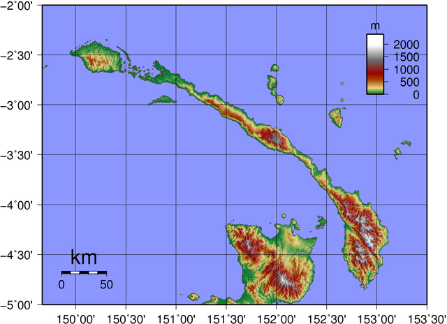
| Description | Topographic map of New Ireland in Papua New Guinea. Created with GMT from publicly released SRTM data. |
| Date | |
| Source | Own work |
| Author | Sadalmelik |
Licensing
| I, the copyright holder of this work, release this work into the
public domain. This applies worldwide. In some countries this may not be legally possible; if so: I grant anyone the right to use this work for any purpose, without any conditions, unless such conditions are required by law. |
File history
Click on a date/time to view the file as it appeared at that time.
| Date/Time | Thumbnail | Dimensions | User | Comment | |
|---|---|---|---|---|---|
| current | 22:29, 5 June 2007 |
| 2,672 × 1,937 (1.17 MB) | Sadalmelik | {{Information |Description=Topographic map of New Ireland in Papua New Guinea. Created with GMT from publicly released SRTM data. |Source=self-made |Date=June 6, 2007 |Author= User:Sadalmelik }} Category:Maps of Papua New Guinea [[Category:Topog |
File usage
The following pages on the English Wikipedia use this file (pages on other projects are not listed):
Global file usage
The following other wikis use this file:
- Usage on af.wikipedia.org
- Usage on als.wikipedia.org
- Usage on be.wikipedia.org
- Usage on bg.wikipedia.org
- Usage on de.wikipedia.org
- Usage on de.wikivoyage.org
- Usage on el.wikipedia.org
- Usage on eo.wikipedia.org
- Usage on et.wikipedia.org
- Usage on fr.wikipedia.org
- Usage on gl.wikipedia.org
- Usage on he.wikipedia.org
- Usage on it.wikipedia.org
- Usage on ko.wikipedia.org
- Usage on la.wikipedia.org
- Usage on lt.wikipedia.org
- Usage on nl.wikipedia.org
- Usage on no.wikipedia.org
- Usage on pl.wikipedia.org
- Usage on pt.wikipedia.org
- Usage on sk.wikipedia.org
- Usage on sv.wikipedia.org
- Usage on ta.wikipedia.org
- Usage on uk.wikipedia.org
- Usage on vi.wikipedia.org
- Usage on www.wikidata.org
- Usage on zh.wikipedia.org
Size of this preview:
800 × 580 pixels. Other resolutions:
320 × 232 pixels |
640 × 464 pixels |
1,024 × 742 pixels |
1,280 × 928 pixels |
2,672 × 1,937 pixels.
Original file (2,672 × 1,937 pixels, file size: 1.17 MB, MIME type: image/png)
| This is a file from the
Wikimedia Commons. Information from its
description page there is shown below. Commons is a freely licensed media file repository. You can help. |
Summary
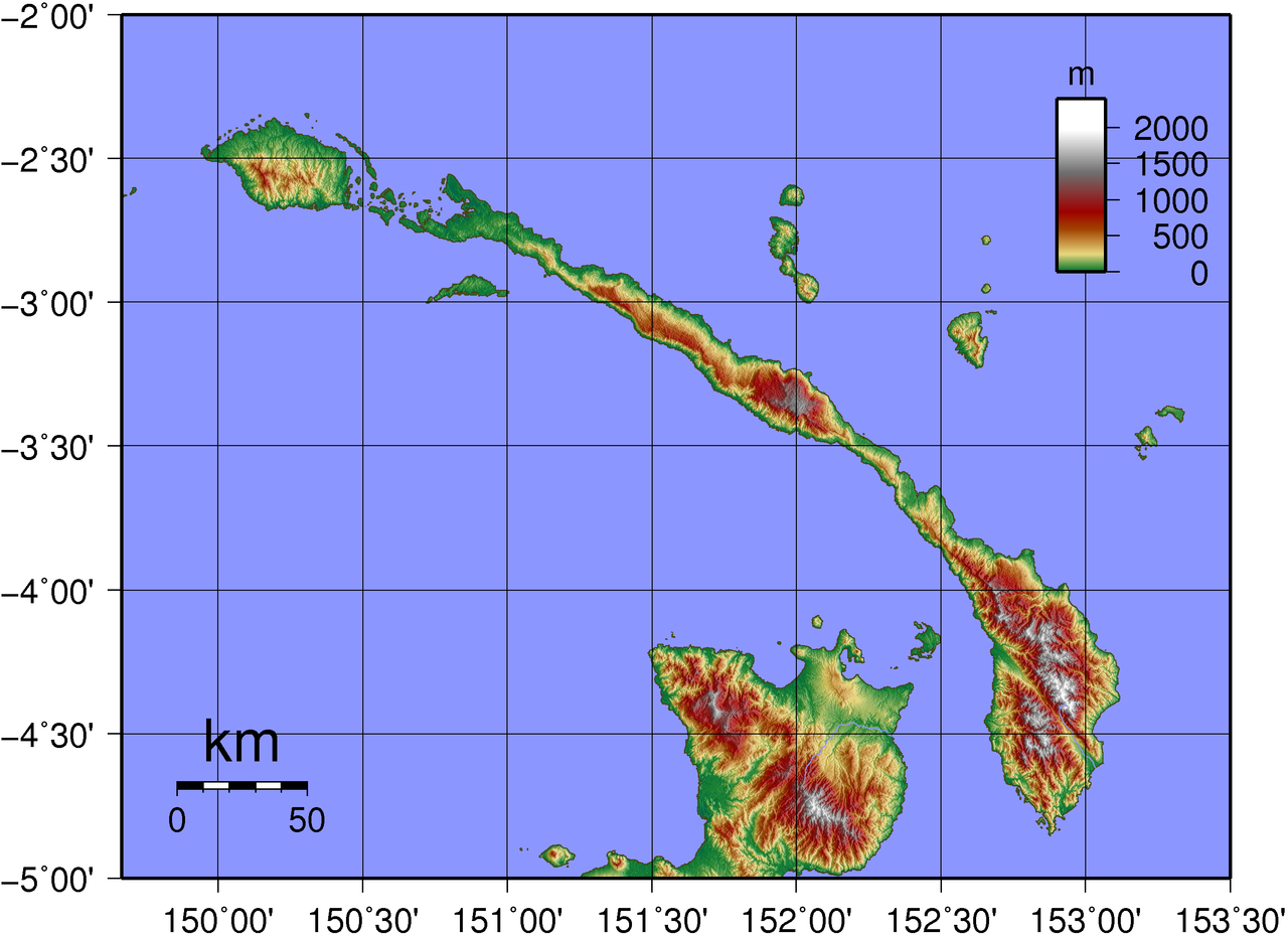
| Description | Topographic map of New Ireland in Papua New Guinea. Created with GMT from publicly released SRTM data. |
| Date | |
| Source | Own work |
| Author | Sadalmelik |
Licensing
| I, the copyright holder of this work, release this work into the
public domain. This applies worldwide. In some countries this may not be legally possible; if so: I grant anyone the right to use this work for any purpose, without any conditions, unless such conditions are required by law. |
File history
Click on a date/time to view the file as it appeared at that time.
| Date/Time | Thumbnail | Dimensions | User | Comment | |
|---|---|---|---|---|---|
| current | 22:29, 5 June 2007 |
| 2,672 × 1,937 (1.17 MB) | Sadalmelik | {{Information |Description=Topographic map of New Ireland in Papua New Guinea. Created with GMT from publicly released SRTM data. |Source=self-made |Date=June 6, 2007 |Author= User:Sadalmelik }} Category:Maps of Papua New Guinea [[Category:Topog |
File usage
The following pages on the English Wikipedia use this file (pages on other projects are not listed):
Global file usage
The following other wikis use this file:
- Usage on af.wikipedia.org
- Usage on als.wikipedia.org
- Usage on be.wikipedia.org
- Usage on bg.wikipedia.org
- Usage on de.wikipedia.org
- Usage on de.wikivoyage.org
- Usage on el.wikipedia.org
- Usage on eo.wikipedia.org
- Usage on et.wikipedia.org
- Usage on fr.wikipedia.org
- Usage on gl.wikipedia.org
- Usage on he.wikipedia.org
- Usage on it.wikipedia.org
- Usage on ko.wikipedia.org
- Usage on la.wikipedia.org
- Usage on lt.wikipedia.org
- Usage on nl.wikipedia.org
- Usage on no.wikipedia.org
- Usage on pl.wikipedia.org
- Usage on pt.wikipedia.org
- Usage on sk.wikipedia.org
- Usage on sv.wikipedia.org
- Usage on ta.wikipedia.org
- Usage on uk.wikipedia.org
- Usage on vi.wikipedia.org
- Usage on www.wikidata.org
- Usage on zh.wikipedia.org