Size of this preview:
800 ├Ś 357 pixels. Other resolutions:
320 ├Ś 143 pixels |
640 ├Ś 286 pixels |
1,024 ├Ś 457 pixels |
1,280 ├Ś 571 pixels |
3,011 ├Ś 1,344 pixels.
Original file (3,011 ├Ś 1,344 pixels, file size: 4.46 MB, MIME type: image/png)
| This is a file from the
Wikimedia Commons. Information from its
description page there is shown below. Commons is a freely licensed media file repository. You can help. |
Summary
| Description |
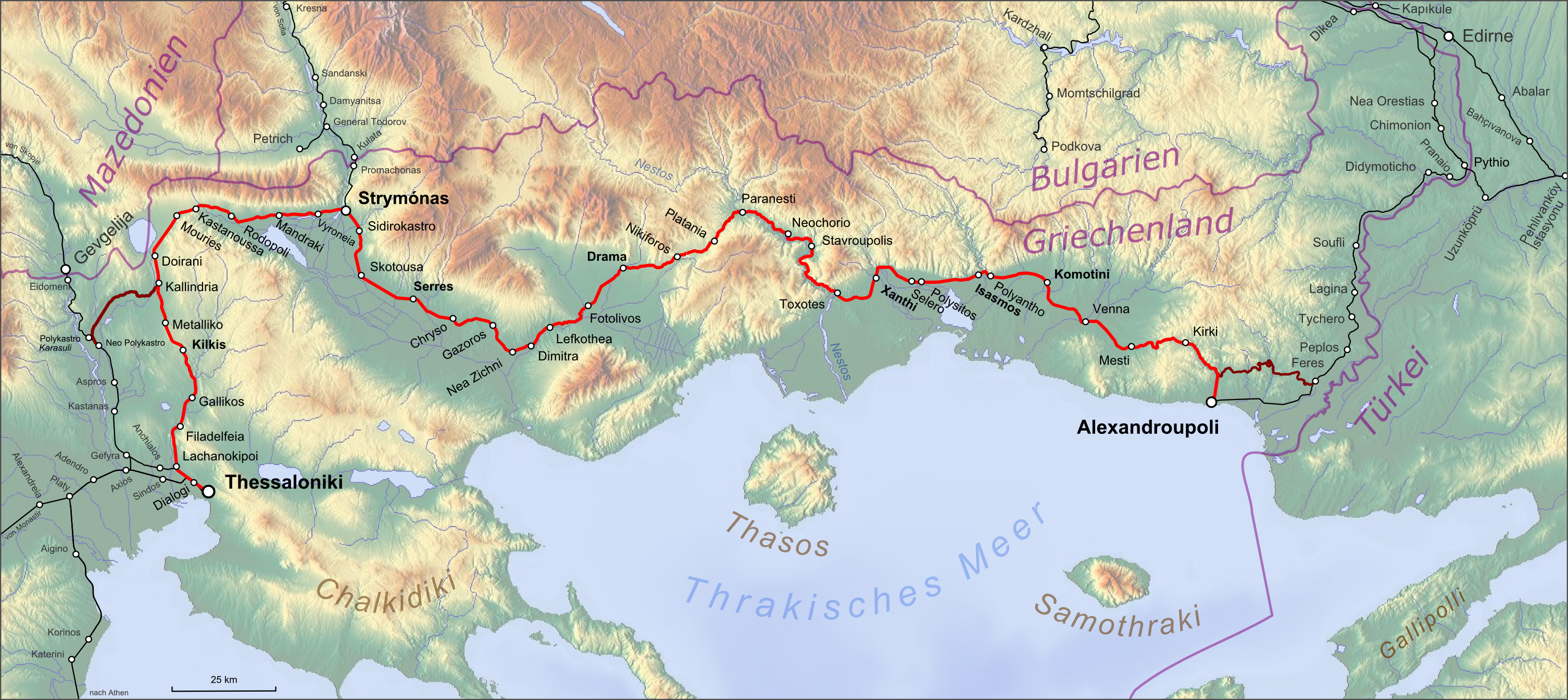
English: Network of the Soci├®t├® du Chemin de Fer Ottoman Jonction SaloniqueŌĆōConstantinople operated from 1895 till 1915. Map shows still existing main line in red and abandoned or razed branch lines in brown. Other railway lines shown in black. Map background shows borders of 2018 |
|||||||||
| Date | ||||||||||
| Source |
|
|||||||||
| Creator |
|
|||||||||
| Geotemporal data | ||||||||||
| Bounding box |
|
|||||||||
| Georeferencing | ||||||||||
| This work is licensed under the Open Database License ( summary). |

|
Permission is granted to copy, distribute and/or modify this document under the terms of the GNU Free Documentation License, Version 1.2 or any later version published by the Free Software Foundation; with no Invariant Sections, no Front-Cover Texts, and no Back-Cover Texts. A copy of the license is included in the section entitled GNU Free Documentation License. |
File history
Click on a date/time to view the file as it appeared at that time.
| Date/Time | Thumbnail | Dimensions | User | Comment | |
|---|---|---|---|---|---|
| current | 22:02, 5 July 2018 |
| 3,011 ├Ś 1,344 (4.46 MB) | Pechristener | {{Information |description={{en|Network of the Soci├®t├® du Chemin de Fer Ottoman Jonction SaloniqueŌĆōConstantinople operated from 1895 till 1915. Map shows still existing main line in red and abandoned or razed branch lines in brown. Other railway lines shown in black. Map background shows borders of 2018}} |date=2018-07-05 |source= * Background: [http://www.maps-for-free.com maps-for-free.com] * Topic: OSM data |author= * Background: [http://www.maps-for-free.com maps-for-free.com] * Topic: O... |
File usage
The following pages on the English Wikipedia use this file (pages on other projects are not listed):
Global file usage
The following other wikis use this file:
- Usage on bg.wikipedia.org
- Usage on de.wikipedia.org
- Usage on it.wikipedia.org
- Usage on www.wikidata.org
Metadata
Size of this preview:
800 ├Ś 357 pixels. Other resolutions:
320 ├Ś 143 pixels |
640 ├Ś 286 pixels |
1,024 ├Ś 457 pixels |
1,280 ├Ś 571 pixels |
3,011 ├Ś 1,344 pixels.
Original file (3,011 ├Ś 1,344 pixels, file size: 4.46 MB, MIME type: image/png)
| This is a file from the
Wikimedia Commons. Information from its
description page there is shown below. Commons is a freely licensed media file repository. You can help. |
Summary
| Description |
English: Network of the Soci├®t├® du Chemin de Fer Ottoman Jonction SaloniqueŌĆōConstantinople operated from 1895 till 1915. Map shows still existing main line in red and abandoned or razed branch lines in brown. Other railway lines shown in black. Map background shows borders of 2018 |
|||||||||
| Date | ||||||||||
| Source |
|
|||||||||
| Creator |
|
|||||||||
| Geotemporal data | ||||||||||
| Bounding box |
|
|||||||||
| Georeferencing | ||||||||||
| This work is licensed under the Open Database License ( summary). |
|
|
Permission is granted to copy, distribute and/or modify this document under the terms of the GNU Free Documentation License, Version 1.2 or any later version published by the Free Software Foundation; with no Invariant Sections, no Front-Cover Texts, and no Back-Cover Texts. A copy of the license is included in the section entitled GNU Free Documentation License. |
File history
Click on a date/time to view the file as it appeared at that time.
| Date/Time | Thumbnail | Dimensions | User | Comment | |
|---|---|---|---|---|---|
| current | 22:02, 5 July 2018 |
| 3,011 ├Ś 1,344 (4.46 MB) | Pechristener | {{Information |description={{en|Network of the Soci├®t├® du Chemin de Fer Ottoman Jonction SaloniqueŌĆōConstantinople operated from 1895 till 1915. Map shows still existing main line in red and abandoned or razed branch lines in brown. Other railway lines shown in black. Map background shows borders of 2018}} |date=2018-07-05 |source= * Background: [http://www.maps-for-free.com maps-for-free.com] * Topic: OSM data |author= * Background: [http://www.maps-for-free.com maps-for-free.com] * Topic: O... |
File usage
The following pages on the English Wikipedia use this file (pages on other projects are not listed):
Global file usage
The following other wikis use this file:
- Usage on bg.wikipedia.org
- Usage on de.wikipedia.org
- Usage on it.wikipedia.org
- Usage on www.wikidata.org